. 2023 Mar 2:47:109022.
doi: 10.1016/j.dib.2023.109022. eCollection 2023 Apr.

2002-2017 anthropogenic emissions data for air quality modeling over the United States

Affiliations

2002-2017 anthropogenic emissions data for air quality modeling over the United States

Kristen M Foley et al. Data Brief. .

Abstract

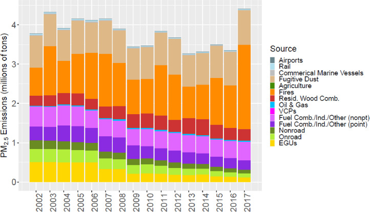
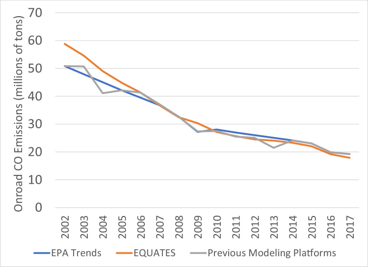
The United States Environmental Protection Agency (US EPA) has developed a set of annual North American emissions data for multiple air pollutants across 18 broad source categories for 2002 through 2017. The sixteen new annual emissions inventories were developed using consistent input data and methods across all years. When a consistent method or tool was not available for a source category, emissions were estimated by scaling data from the EPA's 2017 National Emissions Inventory with scaling factors based on activity data and/or emissions control information. The emissions datasets are designed to support regional air quality modeling for a wide variety of human health and ecological applications. The data were developed to support simulations of the EPA's Community Multiscale Air Quality model but can also be used by other regional scale air quality models. The emissions data are one component of EPA's Air Quality Time Series Project which also includes air quality modeling inputs (meteorology, initial conditions, boundary conditions) and outputs (e.g., ozone, PM2.5 and constituent species, wet and dry deposition) for the Conterminous US at a 12 km horizontal grid spacing.

Keywords: Air quality modeling; CMAQ; Emissions inventory; Emissions trends; MOVES; SMOKE.


Conflict of interest statement

The authors declare that they have no known competing financial interests or personal relationships which have or could be perceived to have influenced the work reported in this article.

Figures

Fig 1
Fig. 1
EQUATES modeling domain (“12US1”; 459 columns × 299 rows × 35 vertical layers) for the CONUS at a 12 km horizontal grid spacing is shown as the bold rectangle. The grey shading indicates grid cells that are considered in the CONUS, including federal waters, when calculating the emissions totals in Table 3.
Fig 2
Fig. 2
Annual total NOX emissions (106 short tons as NO2) by source over all grid cells overlapping the CONUS (including federal waters) from the MR emissions files. Note that NOX from soil or lightning are not included as these are calculated online by CMAQ.
Fig 3
Fig. 3
Annual total SO2 emissions (106 short tons) by source over all grid cells overlapping the CONUS (including federal waters) from the MR emissions files.
Fig 4
Fig. 4
Annual total CO emissions (106 short tons) by source over all grid cells overlapping the CONUS (including federal waters) from the MR emissions files. Note that emissions from biogenic sources are not included as these are calculated online by CMAQ.
Fig 5
Fig. 5
Annual total PM2.5 emissions (106 short tons) by source over all grid cells overlapping the CONUS (including federal waters) from the MR emissions files. Note that emissions from sea spray are not included as these are calculated online by CMAQ.
Fig 6
Fig. 6
Annual total POC emissions (106 short tons) by source over all grid cells overlapping the CONUS (including federal waters) from the MR emissions files.
Fig 7
Fig. 7
Annual total PEC emissions (106 short tons) by source over all grid cells overlapping the CONUS (including federal waters) from the MR emissions files.
Fig 8
Fig. 8
Annual total regulatory VOC emissions (106 short tons) by source over all grid cells overlapping the CONUS (including federal waters) from the MR emissions files. For VCPs, VOC was determined from NMOG using the ratio of NMOG to regulatory VOCs of 1.18 following Seltzer et al. . Note that emissions from biogenic sources are not included as these are calculated online by CMAQ.
Fig 9
Fig. 9
Annual total NMOG emissions (106 short tons) by source over all grid cells overlapping the CONUS (including federal waters) from the MR emissions files. Note that emissions from biogenic sources are not included as these are calculated online by CMAQ.
Fig 10
Fig. 10
Annual total NH3 emissions (106 short tons) by source over all grid cells overlapping the CONUS (including federal waters) from the MR emissions files. Note that emissions from agriculture (top of stacked bar and shown in green) include NH3 emissions from fertilizer that were calculated online by CMAQ.
Fig 11
Fig. 11
Annual total SO2 emissions (106 short tons) over the Lower 48 from EQUATES INV files (orange), EPA Trends data (blue) and previous emissions modeling platform data (grey).
Fig 12
Fig. 12
Annual total NOx emissions (106 short tons) over the Lower 48 from EQUATES INV files (orange), EPA Trends data (blue) and previous emissions modeling platform data (grey).
Fig 13
Fig. 13
Annual total NOx emissions from onroad vehicles (106 short tons) over the Lower 48 from EQUATES INV files (orange), EPA Trends data (blue) and previous emissions modeling platform data (grey).
Fig 14
Fig. 14
Annual total PM2.5 emissions (106 short tons) over the Lower 48 from EQUATES INV files (orange), EPA Trends data (blue) and previous emissions modeling platform data (grey).
Fig 15
Fig. 15
Annual total PM2.5 emissions from wild and prescribed fires (106 short tons) over the Lower 48 from EQUATES INV files (orange), EPA Trends data (blue) and previous emissions modeling platform data (grey).
Fig 16
Fig. 16
Annual total CO emissions (106 short tons) over the Lower 48 from EQUATES INV files (orange), EPA Trends data (blue) and previous emissions modeling platform data (grey).
Fig 17
Fig. 17
Annual total CO emissions from onroad vehicles (106 short tons) over the Lower 48 from EQUATES INV files (orange), EPA Trends data (blue) and previous emissions modeling platform data (grey).
Fig 18
Fig. 18
Annual total CO emissions from wild and prescribed fires (106 short tons) over the Lower 48 from EQUATES INV files (orange), EPA Trends data (blue) and previous emissions modeling platform data (grey).
Fig 19
Fig. 19
Annual total regulatory VOC emissions (106 short tons) over the Lower 48 from EQUATES INV files (orange), EPA Trends data (blue) and previous emissions modeling platform data (grey).
Fig 20
Fig. 20
Annual total regulatory VOC emissions from onroad vehicles (106 short tons) over the Lower 48 from EQUATES INV files (orange), EPA Trends data (blue) and previous emissions modeling platform data (grey).
Fig 21
Fig. 21
Annual total regulatory VOC emissions from wild and prescribed fires (106 short tons) over the Lower 48 from EQUATES INV files (orange), EPA Trends data (blue) and previous emissions modeling platform data (grey).
Fig 22
Fig. 22
Annual total regulatory VOC emissions from VCPs (106 short tons) over the Lower 48 from EQUATES INV files (orange), EPA Trends data (blue) and previous emissions modeling platform data (grey).
Fig 23
Fig. 23
Annual total regulatory VOC emissions from oil and gas sources (106 short tons) over the Lower 48 from EQUATES INV files (orange), EPA Trends data (blue) and previous emissions modeling platform data (grey).
Fig 24
Fig. 24
Annual total NH3 emissions (106 short tons) over the Lower 48 from EQUATES INV files (orange), EPA Trends data (blue) and previous emissions modeling platform data (grey).
Fig 25
Fig. 25
Annual total NH3 emissions from livestock, part of the agriculture category, (106 short tons) over the Lower 48 from EQUATES INV files (orange) and previous emissions modeling platform data (grey).

References

    1. U.S. Environmental Protection Agency, EPA needs to improve air emissions data for the oil and natural gas production sector, EPA Report No. 13-P-0161, February 20, 2013. https://www.epa.gov/sites/default/files/2015-09/documents/20130220-13-p-...
    1. Seltzer K.M., Pennington E., Rao V., Murphy B.N., Strum M., Isaacs K.K., Pye H.O.T. Reactive organic carbon emissions from volatile chemical products. Atmos. Chem. Phys. 2021;21:5079–5100. doi: 10.5194/acp-21-5079-2021. - DOI - PMC - PubMed
    1. [software] Unidata . UCAR/Unidata; Boulder, CO: 2021. Network Common Data Form (NetCDF) version 4.8.0. - DOI
    1. Simon H., Beck L., Bhave P.V., Divita F., Hsu Y., Luecken D., Mobley J.D., Pouliot G.A., Reff A., Sarwar G., Strum M. The development and uses of EPA's SPECIATE database. Atmos. Pollut. Res. 2010;1:196–206.
    1. Bray C.D., Strum M., Simon H., Riddick L., Kosusko M., Menetrez M., Hays M.D., Rao V. An assessment of important SPECIATE profiles in the EPA emissions modeling platform and current data gaps. Atmos. Environ. 2019;207:93–104. - PMC - PubMed