

Characterizing uncertainty in Community Land Model version 5 hydrological applications in the United States
- PMID: 37024517
- PMCID: PMC10079652
- DOI: 10.1038/s41597-023-02049-7
Characterizing uncertainty in Community Land Model version 5 hydrological applications in the United States
Abstract
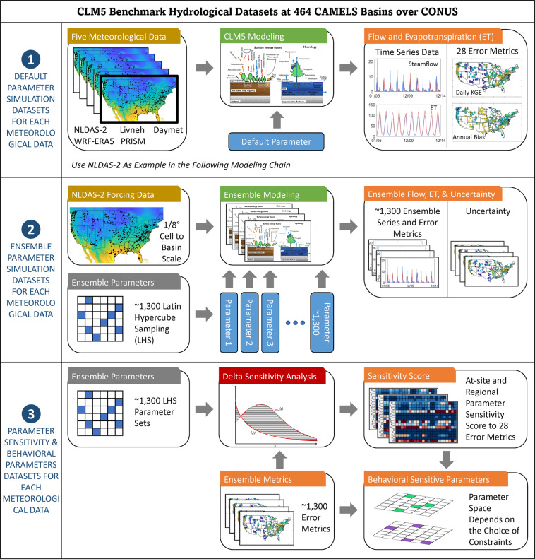
Land surface models such as the Community Land Model Version 5 (CLM5) are essential tools for simulating the behavior of the terrestrial system. Despite the extensive application of CLM5, limited attention has been paid to the underlying uncertainties associated with its hydrological parameters and how these uncertainties affect water resource applications. To address this long-standing issue, we use five meteorological datasets to conduct a comprehensive hydrological parameter uncertainty characterization of CLM5 over the hydroclimatic gradients of the conterminous United States. Key datasets produced from the uncertainty characterization experiment include: a benchmark dataset of CLM5 default hydrological performance, parameter sensitivities for 28 hydrological metrics, and large-ensemble outputs for CLM5 hydrological predictions. The presented datasets will assist CLM5 calibration and support broad applications, such as evaluating drought and flood vulnerabilities. The datasets can be used to identify the hydroclimatological conditions under which parametric uncertainties demonstrate substantial effects on hydrological predictions and clarify where further investigations are needed to understand how hydrological prediction uncertainties interact with other Earth system processes.
© 2023. Battelle Memorial Institute.
Conflict of interest statement
The authors declare no competing interests.
Figures
References
-
- Bales RC, et al. Mountain hydrology of the western United States. Water Resour. Res. 2006;42:W08432. doi: 10.1029/2005WR004387. - DOI
-
- Yan H, Sun N, Chen X, Wigmosta MS. Next-Generation Intensity-Duration-Frequency Curves for Climate-Resilient Infrastructure Design: Advances and Opportunities. Front. Water. 2020;2:545051. doi: 10.3389/frwa.2020.545051. - DOI
-
- Yan H, et al. Observed Spatiotemporal Changes in the Mechanisms of Extreme Water Available for Runoff in the Western United States. Geophys. Res. Lett. 2019;46:767–775. doi: 10.1029/2018GL080260. - DOI
-
- Hou, Z. et al. Incorporating climate nonstationarity and snowmelt processes in intensity–duration–frequency analyses with case studies in mountainous areas. J. Hydrometeorol. 20 (2019).
MeSH terms
LinkOut - more resources
Full Text Sources
