. 2023 Jan;128(1):e2022JE007185.
doi: 10.1029/2022JE007185. Epub 2022 Dec 30.

The Curiosity Rover's Exploration of Glen Torridon, Gale Crater, Mars: An Overview of the Campaign and Scientific Results

Affiliations

The Curiosity Rover's Exploration of Glen Torridon, Gale Crater, Mars: An Overview of the Campaign and Scientific Results

Kristen A Bennett et al. J Geophys Res Planets. 2023 Jan.

Abstract

The Mars Science Laboratory rover, Curiosity, explored the clay mineral-bearing Glen Torridon region for 1 Martian year between January 2019 and January 2021, including a short campaign onto the Greenheugh pediment. The Glen Torridon campaign sought to characterize the geology of the area, seek evidence of habitable environments, and document the onset of a potentially global climatic transition during the Hesperian era. Curiosity roved 5 km in total throughout Glen Torridon, from the Vera Rubin ridge to the northern margin of the Greenheugh pediment. Curiosity acquired samples from 11 drill holes during this campaign and conducted the first Martian thermochemolytic-based organics detection experiment with the Sample Analysis at Mars instrument suite. The lowest elevations within Glen Torridon represent a continuation of lacustrine Murray formation deposits, but overlying widespread cross bedded sandstones indicate an interval of more energetic fluvial environments and prompted the definition of a new stratigraphic formation in the Mount Sharp group called the Carolyn Shoemaker formation. Glen Torridon hosts abundant phyllosilicates yet remains compositionally and mineralogically comparable to the rest of the Mount Sharp group. Glen Torridon samples have a great diversity and abundance of sulfur-bearing organic molecules, which are consistent with the presence of ancient refractory organic matter. The Glen Torridon region experienced heterogeneous diagenesis, with the most striking alteration occurring just below the Siccar Point unconformity at the Greenheugh pediment. Results from the pediment campaign show that the capping sandstone formed within the Stimson Hesperian aeolian sand sea that experienced seasonal variations in wind direction.


Figures

Figure 1
Figure 1
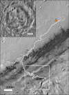
Upper left inset: THEMIS‐VIS Band 3 mosaic of Gale crater (Bennett, Hill, et al., 2018). The white box shows location of the rest of the figure. Main figure: CTX image (D01_027557_1754_XN_04S222W) showing the Curiosity rover's traverse (white line) through sol 3149. The triangle shows the landing site. The white box shows the location of Figure 2 and contains the study area of this campaign.
Figure 2
Figure 2
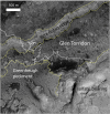
HiRISE image (ESP_053732_1750) showing the geomorphic features in and around the study area. Glen Torridon is a trough that is bounded to the north by Vera Rubin ridge and to the south by the Greenheugh pediment and the sulfate‐bearing unit. Yellow dashed lines highlight the boundaries between these geomorphic features and the white line shows the traverse path.
Figure 3
Figure 3
(a) Three‐dimensional view of the Glen Torridon area showing the stratigraphic units that outcrop here. The white line is the rover traverse. Pink lines show the boundaries between the stratigraphic members in the Mount Sharp group. The orange line shows the extent of the Siccar Point group. The blue line shows the location of the cross section shown in panel (b). (b) Cross section showing the stratigraphic members in Glen Torridon and the surrounding area, including Vera Rubin ridge (labeled VRR in the figure). The extent of Glen Torridon, Vera Rubin ridge, and the Greenheugh pediment is demonstrated by the red lines. Note that the Jura member outcrops in both Glen Torridon and Vera Rubin ridge. Adapted from Fedo et al. (2022). (c) The composite stratigraphic column of Gale crater strata characterized by Curiosity. The stratigraphic column is adapted from Fedo et al. (2022).
Figure 4
Figure 4
Prior to in‐situ exploration, Glen Torridon was divided into the smooth, ridged clay‐bearing unit, the fractured clay‐bearing unit, and the fractured intermediate unit based on orbital morphology, textures, and mineralogy. (a) Compact Reconnaissance Imaging Spectrometer for Mars (CRISM) smectite parameter map (Background: grayscale Gale orthophoto mosaic from Calef and Parker (2016)). Purple shaded areas show locations of enhanced smectite signatures, with darker shades of purple exhibiting stronger signatures (CRISM observation FRT0000B6F1_07_IF165L_TRR3, 2.9 μm band depth as processed in He et al. (2022)). Dashed yellow lines show geomorphic boundaries from Figure 2. White line shows the rough boundary between the clay‐bearing unit and the fractured intermediate unit that does not exhibit clear enhanced smectite signatures. White box shows the location of panel (b). (b) HiRISE color image (ESP_060840_1750) showing the three orbitally defined sub‐units within Glen Torridon. (c) Smooth, ridged clay‐bearing unit. (d) Fractured clay‐bearing unit. (e) Fractured intermediate unit.
Figure 5
Figure 5
Curiosity's traverse area within Glen Torridon. The white line is the rover traverse path and the red circles are stops along the traverse. The numbers correspond to the 10 waypoints defined in Section 4.1 (HiRISE image ESP_060840_1750). Stars indicate drill sample locations. The stratigraphic members are labeled, and the member boundaries are denoted by the pink lines.
Figure 6
Figure 6
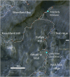
Detailed view of the traverse from the Vera Rubin ridge descent to the start of the butte investigation. Background: HiRISE image ESP_060840_1750. The white line is the rover traverse path and the brown circles are stops along the traverse. The blue stars are drill locations. Inset shows a HiRISE image (ESP_037117_1755) of Curiosity investigating a small impact crater near Antonine Wall (scalebar is 10 m).
Figure 7
Figure 7
Mastcam mosaic (2309ML012330; NASA/JPL‐Caltech/MSSS) acquired shortly after entering Glen Torridon. The mosaic shows the southern scarp of Vera Rubin ridge, the crossbedded Knockfarril Hill outcrop, and the typical heavily (“rubbly”) eroded surface texture that gives the clay‐bearing unit's characteristic smooth texture in HiRISE images. Light‐toned mega ripples are visible on the left side of the image.
Figure 8
Figure 8
Context Mastcam view of the Waypoint 3 area, looking East along Vera Rubin ridge on the left and toward Mt Sharp on the right. The white and yellow arrows points to the Aberlady and Kilmarie drill holes, respectively. The rover tracks in the foreground are ∼40 cm wide. This region is representative of the highly eroded terrain characteristic of lower Glen Torridon, which made locating blocks of sufficient size to drill challenging. Refer to Figure 6 for the orbital context (2411ML012780; NASA/JPL‐Caltech/MSSS).
Figure 9
Figure 9
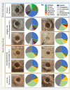
Mars Hand Lens Imager (MAHLI) image and CheMin bulk mineralogy of drilled samples withing the Glen Torridon region. The drill hole is ∼1.6 cm in diameter. MAHLI Images used—Aberlady: 2378MH0007740010900199C00; Kilmarie: 2404MH0007740010900288C00; Glen Etive: 2524MH0007740010903140C00; Glen Etive 2: 2550MH0007740010903254C00; Glasgow: 2773MH0004240011002826C00; Mary Anning: 2851MH0001970011003289C00; Mary Anning 3: 2890MH0004240011003450C00; Groken: 2920MH0004240011003512C00; Hutton: 2684MH0007740011001668C00; Nontron: 3068MH0007740011101168C00; and Edinburgh: 2724MH0007740011002434C00.
Figure 10
Figure 10
Mastcam mosaic (2359ML12506; NASA/JPL‐Caltech/MSSS) of the Woodland Bay target area, which demonstrates the typical bedrock outcrop appearance throughout lower Glen Torridon, as well as the polygonal troughs that form around blocks. Inset (∼10 × 15 cm) showcases a Mars Hand Lens Imager (MAHLI) close‐up of the Morningside target, an example of the thin‐thick laminations in mudstone bedrock that helped classify these rocks as stratigraphically part of the Jura member (MAHLI image; 2424MH0001900010900914C00). Refer to Figure 6 for orbital context.
Figure 11
Figure 11
Linear ridges that trend NE‐SW are especially pronounced in the northern region of Glen Torridon and are capped by Knockfarril Hill member crossbedded sandstones when they extend farther south. Both images here show some of the same landscape features from different viewing angles. Upper image: Mastcam mosaic acquired on Sol 2320 looking E‐SE from the rover's position across several ridges, some of which have cross‐bedded sandstone caps on their southern ends (2320ML12396, NASA/JPL‐Caltech/MSSS). Lower image: Mastcam mosaic acquired on sol 2390 looking south from the rover's position toward the linear ridges, with the Greenheugh pediment scarp and Mount Sharp in the background (2390ML12686, NASA/JPL/MSSS). Inset: HiRISE context of Curiosity's traverse in white, indicating the view angles of both mosaics. In all images, white arrows point to the northern and southern ends of Teal Ridge, which was investigated in‐situ by Curiosity. Arrow points are ∼30 m apart along the crest of Teal ridge.
Figure 12
Figure 12
Mastcam mosaic (2458ML13044, NASA/JPL‐Caltech/MSSS) acquired from Harlaw rise (in foreground) on sol 2458 looking south toward Antonine Wall while Curiosity was characterizing the exposed stratigraphy around waypoint 5. Visible in the background are Rock Nab ridge, several buttes, and the pediment scarp, all eventually investigated in situ. Refer to Figure 6 for orbital context.
Figure 13
Figure 13
Mastcam mosaic (2480ML13164, NASA/JPL‐Caltech/MSSS) obtained on sol 2480 looking west, as the rover drove out of the Visionarium to approach the Glen Etive drill site. The white circle indicates the block from which the Glen Etive samples would be collected, and the white arrows points to the rover tracks from where Curiosity approached the target Antonine Wall to investigate the 3‐dimensional structure of this outcrop. The wheel tracks are 40 cm wide and spaced approximately 3 m apart. Refer to Figure 6 for orbital context.
Figure 14
Figure 14
Left: Detailed view of the traverse through the buttes and the pediment campaign. Background: HiRISE image ESP_060840_1750. The white line is the rover traverse path and the brown circles are stops along the traverse. The blue stars are drill locations. Right: Map of terrain slopes, derived from the HiRISE DEMs, showing the topography of the buttes and pediment scarp. Curiosity reached a maximum rover tilt of 32° while driving to the Edinburgh drill site. The text “sol 2783” marks where the mosaic in Figure 17 was obtained.
Figure 15
Figure 15
Mastcam mosaics of the buttes. The white arrows point to the Stimson formation that caps the pediment. Note that there is no capping unit at Central butte. (a) Central butte (2568ML013483; NASA/JPL‐Caltech/MSSS), (b) Western butte (2671ML014006; NASA/JPL‐Caltech/MSSS), and (c) Tower butte (2628ML013757; NASA/JPL‐Caltech/MSSS).
Figure 16
Figure 16
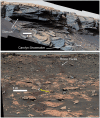
Mastcam mosaics of the pediment and pediment scarp. (a) The contact between the Stimson formation sandstones and the underlying Carolyn Shoemaker formation mudstones (shown by white arrows). The contact and the Carolyn Shoemaker formation are covered by sand and debris (2685MR014053; NASA/JPL‐Caltech/MSSS). (b) The location where Curiosity ascended a 32° slope to reach the top of the pediment. Rover tracks (from both the ascent and descent) are visible (white arrow). The strata beneath the capping Stimson formation are part of the Hutton interval, and the characteristic light‐toned color of this interval is visible where the rover tracks either crushed or broke open rocks to reveal fresh surfaces (yellow arrow) (2737MR014348; NASA/JPL‐Caltech/MSSS).
Figure 17
Figure 17
Mastcam mosaic (2783ML14571, NASA/JPL‐Caltech/MSSS) looking toward the northeast from the rover position on sol 2783 over typical exposures of Glasgow member bedrock. The southern scarp of Vera Rubin ridge is visible in the background.
Figure 18
Figure 18
Mastcam mosaic (2698ML14123, NASA/JPL‐Caltech/MSSS) acquired on sol 2698 near the Edinburgh drill location, looking west across the Greenheugh pediment cap. The cliff edge is visible on the right side of the image, and Gale crater's rim is faintly visible in the background.
Figure 19
Figure 19
Detailed view of the traverse from the Glasgow drill hole to the Mary Anning drill hole. Background: HiRISE image ESP_060840_1750. The white line is the rover traverse path and the brown circles are stops along the traverse. The blue stars are drill locations. The text “sol 2783” marks where the mosaic in Figure 17 was obtained.
Figure 20
Figure 20
Mastcam mosaic (2797ML14656, NASA/JPL‐Caltech/MSSS) of the outcrop exposed at Bloodstone Hill.
Figure 21
Figure 21
Mastcam mosaic (2865ML14954, NASA/JPL‐Caltech/MSSS) of the Mary Anning 3 drill site (white arrow). The drill hole is ∼1.6 cm in diameter. The yellow box indicates where MnO‐rich nodules were identified by the ChemCam instrument and later drilled; Inset shows Mars Hand Lens Imager image 2906MH0004240011003483C00 of the Groken drill target before the sample was collected. Nodules are visible as the dark spots on the rock.
Figure 22
Figure 22
Detailed view of the traverse from the Mary Anning and Groken drill holes past the Sands of Forvie sand sheet to the Nontron drill hole, before the rover began its next mission phase to explore transitional strata to the sulfate‐bearing unit. Background: Gale orthophoto mosaic from Calef and Parker (2016). The white line is the rover traverse path and the blue stars are drill locations. The text “sol 2991” marks where the mosaic in Figure 23 was obtained.
Figure 23
Figure 23
Mastcam 360° mosaic (2991MO15588, NASA/JPL‐Caltech/MSSS) acquired on sol 2991 from the edge of the “Sands of Forvie” basaltic sand deposit. The center of the mosaic looks south from the rover position toward the sulfate‐bearing unit. Rover wheels are approximately 40 cm wide and the distance across the sand to the south is about 235 m. See Figure 22 for orbital context.
Figure 24
Figure 24
Mastcam mosaic (3040ML15879, NASA/JPL‐Caltech/MSSS) acquired on Sol 3040 looking west toward Mont Mercou, in the center of the image. The last drill sample (Nontron) of the Glen Torridon campaign was collected near the base of the exposed cliff face, which is approximately 6 m tall, before the rover ascended to the top of the escarpment to continue exploration of the transition to the sulfate‐bearing unit.

References

    1. Achilles, C. N. , Rampe, E. B. , Downs, R. T. , Bristow, T. F. , Ming, D. W. , Morris, R. V. , et al. (2020). Evidence for multiple diagenetic episodes in ancient fluvial‐lacustrine sedimentary rocks in Gale Crater, Mars. Journal of Geophysical Research: Planets, 125(8), e2019JE006295. 10.1029/2019JE006295 - DOI - PMC - PubMed
    1. Anderson, R. , & Bell, J. F. (2010). Geologic mapping and characterization of Gale Crater and implications for its potential as a Mars Science Laboratory landing site. The Mars Journal, 5, 76–128. 10.1555/mars.2010.0004 - DOI
    1. Banham, S. G. , Gupta, S. , Rubin, D. M. , Edgett, K. S. , Barnes, R. , Van Beek, J. , et al. (2021). A rock record of complex aeolian bedforms in a Hesperian Desert landscape: The Stimson formation as exposed in the Murray buttes, Gale Crater, Mars. Journal of Geophysical Research: Planets, 126(4), e2020JE006554. 10.1029/2020JE006554 - DOI
    1. Banham, S. G. , Gupta, S. , Rubin, D. M. , Bedford, C. C. , Edgar, L. , Bryk, A. B. , et al. (2022). Evidence for seasonal‐ to millennial‐scale wind fluctuations in an ancient aeolian dune field: Reconstruction of the Hesperian Stimson formation at Glen Torridon, Gale crater, Mars. Journal of Geophysical Research: Planets, 127, e2021JE007023. 10.1029/2021JE007023 - DOI
    1. Banham, S. G. , Gupta, S. , Rubin, D. M. , Watkins, J. A. , Sumner, D. Y. , Edgett, K. S. , et al. (2018). Ancient Martian aeolian processes and palaeomorphology reconstructed from the Stimson formation on the lower slope of Aeolis Mons, Gale crater, Mars. Sedimentology, 65(4), 993–1042. 10.1111/sed.12469 - DOI

LinkOut - more resources