

UAV-Based Wildland Fire Air Toxics Data Collection and Analysis
- PMID: 37050621
- PMCID: PMC10098707
- DOI: 10.3390/s23073561
UAV-Based Wildland Fire Air Toxics Data Collection and Analysis
Abstract
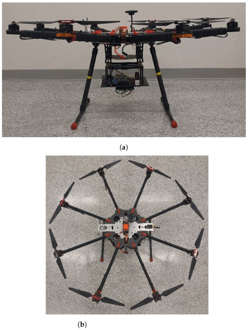
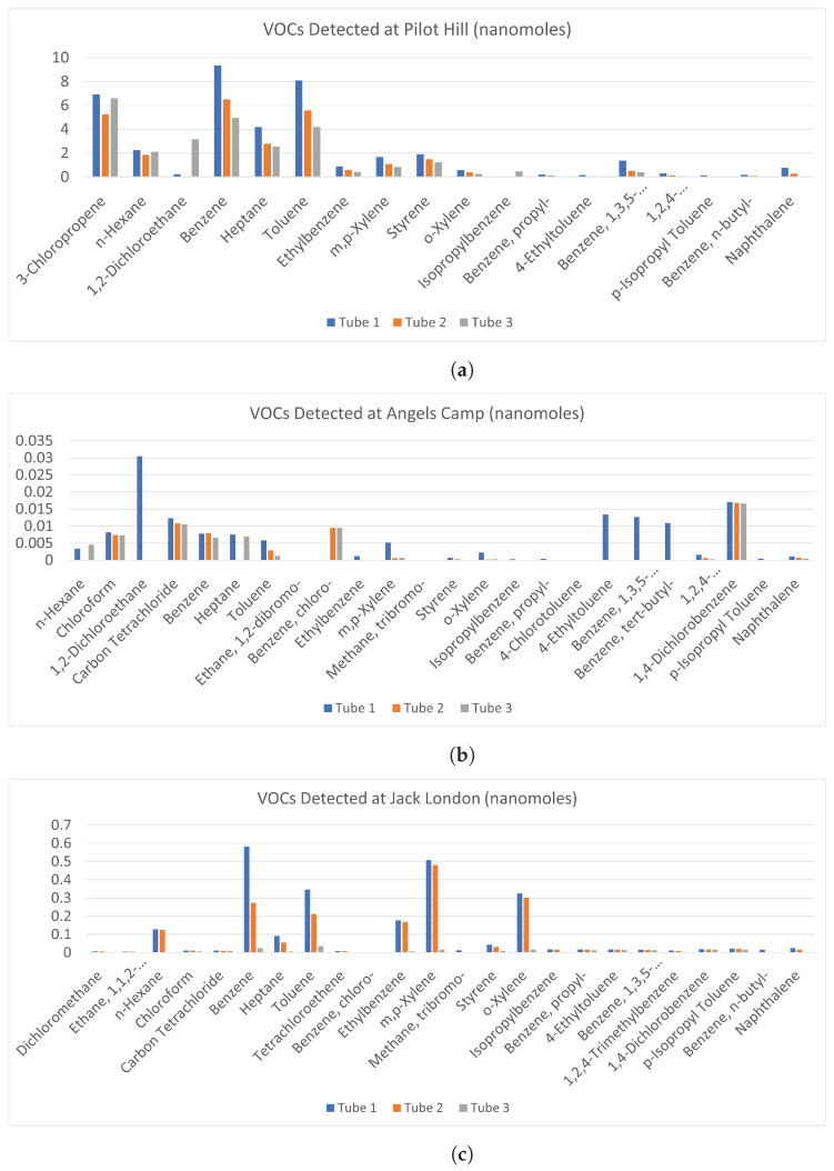
Smoke plumes emitted from wildland-urban interface (WUI) wildfires contain toxic chemical substances that are harmful to human health, mainly due to the burning of synthetic components. Accurate measurement of these air toxics is necessary for understanding their impacts on human health. However, air pollution is typically measured using ground-based sensors, manned airplanes, or satellites, which all provide low-resolution data. Unmanned Aerial Vehicles (UAVs) have the potential to provide high-resolution spatial and temporal data due to their ability to hover in specific locations and maneuver with precise trajectories in 3-D space. This study investigates the use of an octocopter UAV, equipped with a customized air quality sensor package and a volatile organic compound (VOC) air sampler, for the purposes of collecting and analyzing air toxics data from wildfire plumes. The UAV prototype developed has been successfully tested during several prescribed fires conducted by the California Department of Forestry and Fire Protection (CAL FIRE). Data from these experiments were analyzed with emphasis on the relationship between the air toxics measured and the different types of vegetation/fuel burnt. BTEX compounds were found to be more abundant for hardwood burning compared to grassland burning, as expected.
Keywords: Unmanned Aerial Vehicles; air quality monitoring; low-cost sensors; smoke plumes; volatile organic compounds; wildfire.
Conflict of interest statement
The authors declare no conflict of interest. The funders had no role in the design of the study; in the collection, analyses, or interpretation of data; in the writing of the manuscript; or in the decision to publish the results.
Figures
Similar articles
-
Personal and ambient exposures to air toxics in Camden, New Jersey.Res Rep Health Eff Inst. 2011 Aug;(160):3-127; discussion 129-51. Res Rep Health Eff Inst. 2011. PMID: 22097188
-
Environmental sampling of volatile organic compounds during the 2018 Camp Fire in Northern California.J Environ Sci (China). 2021 May;103:135-147. doi: 10.1016/j.jes.2020.10.003. Epub 2020 Nov 6. J Environ Sci (China). 2021. PMID: 33743896 Free PMC article.
-
Responses to Wildfire and Prescribed Fire Smoke: A Survey of a Medically Vulnerable Adult Population in the Wildland-Urban Interface, Mariposa County, California.Int J Environ Res Public Health. 2023 Jan 10;20(2):1210. doi: 10.3390/ijerph20021210. Int J Environ Res Public Health. 2023. PMID: 36673971 Free PMC article.
-
An overview of the development of vertical sampling technologies for ambient volatile organic compounds (VOCs).J Environ Manage. 2019 Oct 1;247:401-412. doi: 10.1016/j.jenvman.2019.06.090. Epub 2019 Jun 26. J Environ Manage. 2019. PMID: 31254756 Review.
-
Adapting western North American forests to climate change and wildfires: 10 common questions.Ecol Appl. 2021 Dec;31(8):e02433. doi: 10.1002/eap.2433. Epub 2021 Oct 13. Ecol Appl. 2021. PMID: 34339088 Free PMC article. Review.
Cited by
-
High Sensitivity Online Sensor for BTEX in Ambient Air Based on Multiphoton Electron Extraction Spectroscopy.Sensors (Basel). 2025 Jul 9;25(14):4268. doi: 10.3390/s25144268. Sensors (Basel). 2025. PMID: 40732396 Free PMC article.
-
A Review on the State of the Art in Copter Drones and Flight Control Systems.Sensors (Basel). 2024 May 23;24(11):3349. doi: 10.3390/s24113349. Sensors (Basel). 2024. PMID: 38894139 Free PMC article. Review.
References
-
- Altshuler S.L., Zhang Q., Kleinman M.T., Garcia-Menendez F., Moore C.T.T., Hough M.L., Stevenson E.D., Chow J.C., Jaffe D.A., Watson J.G. Wildfire and prescribed burning impacts on air quality in the United States. J. Air Waste Manag. Assoc. 2020;70:961–970. doi: 10.1080/10962247.2020.1813217. - DOI - PubMed
-
- Williamson G.J., Bowman D.M.J.S., Price O.F., Henderson S.B., Johnston F.H. A transdisciplinary approach to understanding the health effects of wildfire and prescribed fire smoke regimes. Environ. Res. Lett. 2016;11:125009. doi: 10.1088/1748-9326/11/12/125009. - DOI
