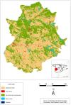
Characterization of the water bodies of Extremadura (SW Spain)
- PMID: 37055643
- PMCID: PMC10101899
- DOI: 10.1007/s10661-023-11187-9
Characterization of the water bodies of Extremadura (SW Spain)
Abstract
Extremadura is the region that stores the greatest amount of fresh water in Spain. Such water is mainly used for power generation, irrigation in agriculture, biodiversity conservation, tourism, recreation, and human and livestock consumption. Nevertheless, crucial information on the total number of water bodies and their geometrical characteristics and spatial distribution patterns are still missing. Thus, our main goal was to characterize the Extremenian water bodies geometrically and spatially through different statistical techniques such as kernel density, Moran's index, the Getis-Ord Gi*, and principal component analysis (PCA). Firstly, all existing hydrological information was gathered, and using aerial aircraft imagery and satellite images, each water body (WB) was then carefully collected, checked, and corrected. We have inventoried 100,614 WBs (mean density: 2.45 WB km2), irregularly distributed on the territory. WBs with an area < 0.01 km2 (100 ha) represent 64.5% of the total. A multivariate statistical study was conducted, showing that livestock, aridity of the climate, and topography are the main factors controlling the density of water bodies (WBs) in this area. It can be concluded that monitoring of small bodies is crucial to understand their spatial distribution, since they are spread over areas in which extensive farming and commercial crops such as tobacco strongly influence the way of living of many families.
Keywords: Agriculture; Land use; Livestock; Reservoirs; Spatial analysis.
© 2023. The Author(s).
Conflict of interest statement
The authors declare no competing interests.
Figures


References
-
- Abdennour MA, Douaoui A, Bradai A, Bennacer A, Pulido Fernández M. Application of kriging techniques for assessing the salinity of irrigated soils: The case of El Ghrous perimeter, Biskra. Algeria. Spanish Journal of Soil Science. 2019;9(2):105–124.
-
- Abdennour, M. A., Douaoui, A., Piccini, C., Pulido, M., Bennacer, A., Bradaï, A., & Yahiaoui, I. (2020). Predictive mapping of soil electrical conductivity as a proxy of soil salinity in south-east of Algeria. Environmental and Sustainability Indicators, 8, 100087. 10.1016/j.indic.2020.100087
-
- Abijith D, Saravanan S, Singh L, Jennifer JJ, Saranya T, Parthasarathy K. GIS-based multi-criteria analysis for identification of potential groundwater recharge zones-a case study from Ponnaniyaru watershed, Tamil Nadu, India. HydroResearch. 2020;3:1–14. doi: 10.1016/j.hydres.2020.02.002. - DOI
-
- Al-Khuzaie MM, Janna H, Al-Ansari N. Assessment model of water harvesting and storage location using GIS and remote sensing in Al-Qadisiyah, Iraq. Arabian Journal of Geosciences. 2020;13:1–9. doi: 10.1007/s12517-020-06154-4. - DOI
-
- Arslan H. Spatial and temporal mapping of groundwater salinity using ordinary kriging and indicator kriging: The case of Bafra Plain, Turkey. Agricultural Water Management. 2012;113:57–63. doi: 10.1016/j.agwat.2012.06.015. - DOI
MeSH terms
Substances
Grants and funding
LinkOut - more resources
Full Text Sources

