. 2023 Apr 25;120(17):e2209615120.
doi: 10.1073/pnas.2209615120. Epub 2023 Apr 17.

Sea-level rise in Southwest Greenland as a contributor to Viking abandonment

Affiliations

Sea-level rise in Southwest Greenland as a contributor to Viking abandonment

Marisa Borreggine et al. Proc Natl Acad Sci U S A. .

Abstract

The first records of Greenland Vikings date to 985 CE. Archaeological evidence yields insight into how Vikings lived, yet drivers of their disappearance in the 15th century remain enigmatic. Research suggests a combination of environmental and socioeconomic factors, and the climatic shift from the Medieval Warm Period (~900 to 1250 CE) to the Little Ice Age (~1250 to 1900 CE) may have forced them to abandon Greenland. Glacial geomorphology and paleoclimate research suggest that the Southern Greenland Ice Sheet readvanced during Viking occupation, peaking in the Little Ice Age. Counterintuitively, the readvance caused sea-level rise near the ice margin due to increased gravitational attraction toward the ice sheet and crustal subsidence. We estimate ice growth in Southwestern Greenland using geomorphological indicators and lake core data from previous literature. We calculate the effect of ice growth on regional sea level by applying our ice history to a geophysical model of sea level with a resolution of ~1 km across Southwestern Greenland and compare the results to archaeological evidence. The results indicate that sea level rose up to ~3.3 m outside the glaciation zone during Viking settlement, producing shoreline retreat of hundreds of meters. Sea-level rise was progressive and encompassed the entire Eastern Settlement. Moreover, pervasive flooding would have forced abandonment of many coastal sites. These processes likely contributed to the suite of vulnerabilities that led to Viking abandonment of Greenland. Sea-level change thus represents an integral, missing element of the Viking story.

Keywords: Norse; archaeology; glacial isostatic adjustment; sea-level change.


Conflict of interest statement

The authors declare no competing interest.

Figures
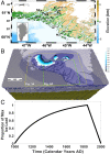
Fig. 1.
Fig. 1.
Regional setting and ice history. (A) The Eastern Settlement of Southern Greenland. The inset shows the entirety of Greenland; dark gray depicts grounded ice cover at present, light gray is land, and white is ocean. Eight black stars show locations of the Viking sites considered herein and also Nanortalik, where Late Holocene relative sea-level data have been collected (11). B is Brattahlid, D is Dyrnaes, G is Gardar, H is Hvalsey, N is Narsaq, N2 is Nanortalik, S1 is Site 1, S2 is Site 2, and uS is Undir Solarfjollum. (B) The tetrahedral grid across Southern Greenland used in the sea-level simulation (top 72 km of Earth’s interior is shown in light gray; surface shading reflects grid resolution and is discussed in Material and Methods Section 3B) with ice mask (blue to white gradient) overlain. The ice mask is estimated from ref. . The yellow box shows an area encompassing the Eastern Settlement and the area of ice growth (the same area is shown in Fig. 3A). The green box shows an area with several important Viking settlements, where coastal flooding is assessed (also seen in Fig. 4A). For more details, Section 3A. (C) Time-varying growth for our ice history, normalized to a maximum value of 1.0, and adapted from refs. –.
Fig. 2.
Fig. 2.
Modeled relative sea level compared to Nanortalik observations. Modeled RSL curve at Nanortalik for a scenario in which local ice sheet advance (Fig. 1) is sufficient to lower GMSL by 7 mm, augmented by the addition of a background sea-level trend due to ongoing ice age effects (Section 1A). Our estimate of the 1-σ uncertainty in the modeled curve is shown in gray shading. Nine orange data points show RSL data of LIA age reconstructed from salt marsh sediments at Nanortalik, with 2-σ age and elevation uncertainty (11).
Fig. 3.
Fig. 3.
Modeled sea-level change from 1000 to 1450 CE in the Eastern Settlement. (A) Map of modeled sea-level change from 1000 to 1450 CE. Black is the present-day Greenland coastline. Eight colored stars show sites of archaeological interest. (B) Prediction of sea-level change during the settlement period at eight archaeological sites from panel A (line colors correspond to site location symbol colors).
Fig. 4.
Fig. 4.
Coastal inundation of the Eastern Settlement from 1000 to 1450 CE, roughly the period of Viking occupation. Beige shading depicts land above sea level by 1450 CE, dark blue is the ocean area at 1000 CE, and light blue is the flooded coastline between 1000 and 1450 CE. Stars on the map denote areas of archaeological interest, as in Fig. 3A. The white star denotes Nanortalik. The grid lines in all panels are spaced ~1 km apart. (A) Coastal flooding of the whole Eastern Settlement region. (BD) Coastal flooding in the northwest, northern-central, and southern regions of the Eastern Settlement. (E) Location of 461 Viking sites tabulated by ref. in white. Zones 1-3, defined in Section 2C as being located 0 to 20 km, 20 to 40 km, and beyond 40 km from the Atlantic coastline, are specified in green contours. The number of sites within each zone is 112, 152, and 197, respectively. (F) Histogram showing the distance of 461 Viking sites to the closest zone of predicted flooding.

References

    1. Barlow L. K., et al. , Interdisciplinary investigations of the end of the Norse Western Settlement in Greenland. Holocene 7, 489–499 (1997).
    1. M. Rasch, J. Fog Jensen, Ancient Eskimo dwelling sites and Holocene relative sea-level changes in southern Disko Bugt, central West Greenland. Polar Res. 16, 101–115 (1997).
    1. A. Thorgilsson, The Book of the Settlement of Iceland (T. Wilson, 1898).
    1. Ó. Halldórsson, Eiríks saga rauða: Texti Skálholtsbékar AM 557 4to, Vol. 4. Hið íslenzka fornritafélag (1985).
    1. J. Arneborg, “Norse Greenland: Reflections on settlement and depopulation” in Contact, Continuity, and Collapse: The Norse Colonization of the North Atlantic (2003), pp. 163–181.

LinkOut - more resources