. 2023 May 31;13(1):8848.
doi: 10.1038/s41598-023-35175-8.

The largest prehistoric mound in Europe is the Bronze-Age Hill of Udine (Italy) and legend linked its origin to Attila the Hun

Affiliations

The largest prehistoric mound in Europe is the Bronze-Age Hill of Udine (Italy) and legend linked its origin to Attila the Hun

A Fontana et al. Sci Rep. .

Abstract

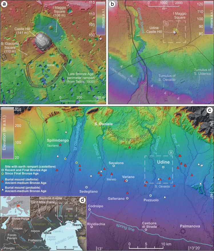
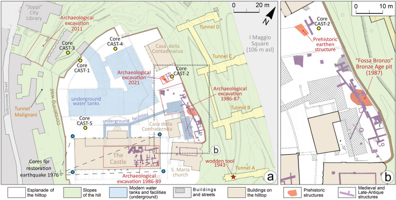
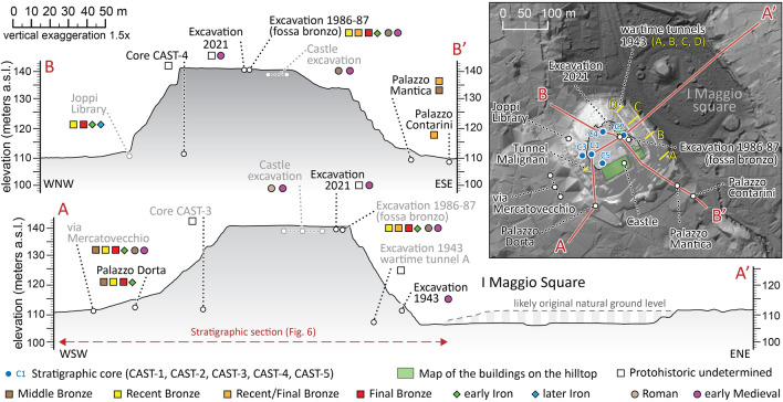
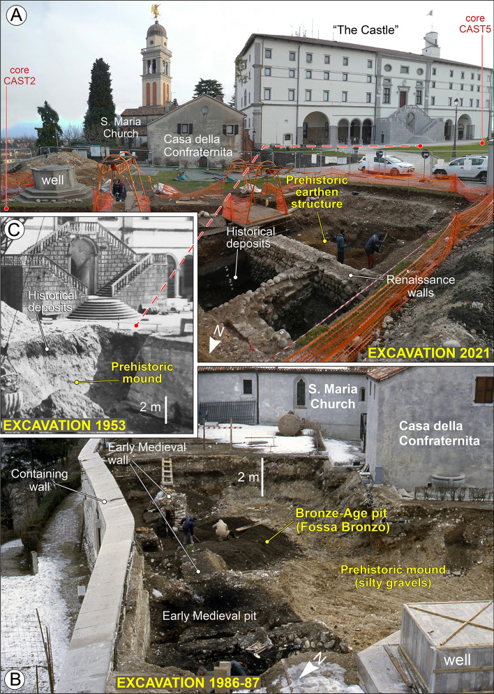
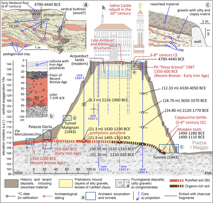
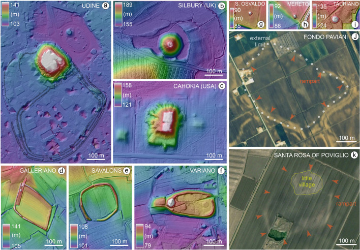
Prehistoric monuments often constitute evident landmarks and sometimes, after falling into disuse, fascinated local people enough to stimulate speculations about their origin over time. According to legend, the Hill of Udine (NE Italy) was built by Attila the Hun's soldiers, but its origin (natural or anthropogenic) has been debated until now. Our research analyzed five new 40-m long stratigraphic cores, investigating for the first time the total thickness of the hill and compared the data with the available archaeological information. Moreover, we considered other hills and mounds in northern Italy and other European regions where folklore traditions relate their origin to Attila. The geoarchaeological and ethnographic data prove that the Hill of Udine is a Bronze Age anthropogenic mound erected between 1400 and 1150 BCE and that, later, folklore has transformed the ancestral memory of its origin into legend. By measuring 30 m in height and over 400,000 m3 in volume, the flat-topped hill is the largest prehistoric mound in Europe. This discovery reveals unprecedented skills in earth construction and confirms significant anthropogenic modifications of the environment during Bronze Age.


Conflict of interest statement

The authors declare no competing interests.

Figures

Figure 1
Figure 1
Digital Terrain Model (DTM) of the study area at local and regional scale, with indication of the sites mentioned in the text. In (a) and (b) the isolated Udine Castle Hill and the depression of I Maggio Square are evident and are not related to any surface deformation, whereas in (b) the arrows highlight the ridge formed by the blind tectonic thrust of Udine-Buttrio.
Figure 2
Figure 2
Detailed map of the hill of Udine with indications of the investigations and archaeological findings. Map of archaeological structures according to Buora. The new stratigraphic cores drilled from the hilltop are indicated in yellow, while the blue dots are the geotechnical cores carried out in 1976 to restore the castle palace after the severe earthquakes that occurred that year. The red star indicates the point of the tunnel A, where a wooden tool had been found in 1943, and we radiocarbon dated it. The map was drawn with software Adobe Illustrator (www.adobe.com).
Figure 3
Figure 3
Topographic profiles of the Hill of Udine obtained by LiDAR data with indications of the stratigraphic cores and archaeological excavations. Profile A-A’ clearly shows the depression now occupied by I Maggio Square, originally occupied by a small lake, drained in the nineteenth Century.
Figure 4
Figure 4
Selection of pictures of the archaeological and stratigraphic excavations carried out on the hill of Udine. (a) Investigations carried out between October and December 2021 identified the sub-superficial occurrence of a prehistoric structure made of alternations of gravelly and clayey lenses (picture by A. Fontana). This area is almost in continuity with the zone depicted in image (b) (Archives of Civici Musei of Udine), where excavation of 1987 all around the building named "Casa della Contadinanza" and near the church of S. Maria found a large pit, named “Fossa Bronzo” (Bronze-Age pit) in Buora. This structure had an areal extent of about 40 m2 and is located at the edge of the hilltop, suggesting that it was near the slope of the mound even in ancient time. The pit was filled with an organic-rich fine matrix and thousands of potsherds. A selection of the most diagnostic fragments of pottery for chrono-typology is reported in Fig. 5 and in Supplementary Fig. S7. The fragments cover a time span between 1400 and 600 BCE, but with the majority of fragments dating to the RBA and FBA (i.e. 1350–950 BCE). (c) Picture taken in 1953, during the work for excavating the water tanks that now occupy most part of the esplanade of the hilltop, up to a depth of about 6 m (see Supplementary Fig. S2) (Archives of Civici Musei of Udine). The site is close to the monumental stairs of the northern entrance of the building called “the Castle”, and it has been documented that alternations of gravels and clays are present below 1.5–2 m of historical deposits rich in the organic component. A similar situation was found in core CAST-5, which is close to this site (see Fig. 4a).
Figure 5
Figure 5
Selection of potsherds found in the pit “fossa bronzo”, investigated in 1987 during the archaeological excavation carried out along the eastern margin of the hilltop of Udine Castle Hill. The different typo-chronological phases are separated according to G. Tasca and the numbers refer to the catalog of fragments published by him.
Figure 6
Figure 6
Stratigraphic section of the Udine mound with indications of cores, tunnels and archaeological excavations. The trace of the section is shown in Fig. 3 as A–A’. (a) 2021 archaeological excavation (test trench of 12 × 8 m). The excavation reached a depth of 3 m and enlightened floors, walls and two tombs dating between the fifth and eighth centuries CE, found just below the present ground surface; the section in the upper box shows the traces of a vertical buttress closely paralleled by the so-called “gabions”, forming the wooden framework of those earth embankments. (b) 2020 archaeological excavation under Palazzo Dorta. The investigation uncovered the floor of a hut of RBA dating to about 1300–1200 BCE, under 4 m of later deposits starting with a gravelly colluvium containing Iron Age potsherds and likely originating from the hill. The RBA deposit overlays the original natural topography; (c) 1943 air-raid shelter tunnels, according to data in Someda De Marco, where a wooden tool was found and radiocarbon dated to RBA; the section in the upper box shows the stratigraphic sequence characterized by inclined successions of gravels and clayey lenses; (d) tunnel “Malignani” dug in 1943 into the western flank of the hill, starting at about 10.3 m above the ground level of the neighboring city center. It was dug 8.5 m horizontally into the hill and, in this case too, the stratigraphic sequence was characterized by inclined successions of gravels and clayey lenses; a detailed section is not available (cf.), see the text for details; (e) Archaeological excavation in Via Mercatovecchio; the detailed section is not displayed in this figure, see the text for details,.
Figure 7
Figure 7
DTMs and aerial images of some of the most representative largest earth structures in the alluvial plains of northern Italy and comparison with Silbury Hill (UK) and Cahokia Monks Mound (Illinois, USA). For location of the Italian sites see Fig. 1. Figure (j) modified from; figure (k) is elaborated from a satellite image of 2003 from Google Earth Maxtar Technologies 2023. The figures were produced elaborating the DEMs and images with software QGIS (https://www.qgis.org) and Adobe Illustrator (www.adobe.com).

References

    1. Hofmann R, Müller J, Shatilo L, Videiko M, Ohlrau R, Rud V, Burdo N, Dal Corso M, Dreibrodt S, Kirleis W. Governing tripolye: Integrative architecture in tripolye settlements. PLoS ONE. 2019;14(9):e0222243. doi: 10.1371/journal.pone.0222243. - DOI - PMC - PubMed
    1. Trigger BG. Monumental architecture: A thermodynamic explanation of symbolic behaviour. World Archaeol. 1990;22:119–132. doi: 10.1080/00438243.1990.9980135. - DOI
    1. Brysbaert A, Klinkenber V, editors. Constructing Monuments, Perceiving Monumentality et the Economics of Building: Theoretical and Methodological Approaches to the Built Environment. Sidestone Press; 2018.
    1. Schmidt, K. Göbekli Tepe. A Stone Age Sanctuary in South-Eastern Anatolia (exOriente, 2012).
    1. Bradley R. The Significance of Monuments: On the Shaping of Human Experience in Neolithic And Bronze Age Europe. Routledge; 1998.

Publication types