

GatorByte - An Internet of Things-Based Low-Cost, Compact, and Real-Time Water Resource Monitoring Buoy
- PMID: 37260521
- PMCID: PMC10227377
- DOI: 10.1016/j.ohx.2023.e00427
GatorByte - An Internet of Things-Based Low-Cost, Compact, and Real-Time Water Resource Monitoring Buoy
Abstract
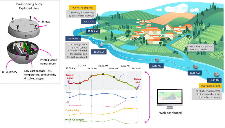
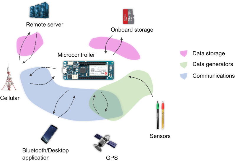
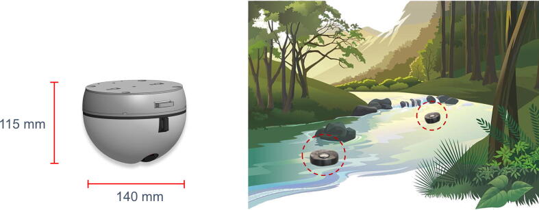
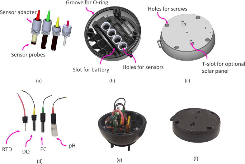
Conventional water resource monitoring systems are usually expensive, have a low-temporal resolution, and lack spatial dimension entirely. These systems are typically available as stations or handheld devices. Pinpointing sources of pollution using these systems can be difficult. This project involves developing a high-resolution free-flowing monitoring buoy that records spatiotemporal water-quality data in flowing stream environments. The system is highly customizable, and even users with limited experience in programming or electronics can tailor GatorByte to their needs. The platform includes a data logger, a cloud-based server, and visualization tools. The data logger uses low-cost sensors, electronic peripherals, a 3D-printed enclosure, and printed circuit boards, with a total cost per unit under $1,000 USD. The data logger uses an NB-IoT-capable Arduino for real-time reporting and visualizing sensor data. The GatorByte records physiochemical water metrics - pH, temperature, dissolved oxygen, electroconductivity, and the current location of the buoy using a GPS module. The data logger also includes micro-SD storage and a Bluetooth module for on-field diagnostics. Using the GatorByte buoy, the collection of variations in water quality data in temporal as well as spatial dimensions can be achieved cost-effectively and reliably, enabling quick detection and resolution of pollution events.
Keywords: Environmental Internet of Things; Low-cost sensors; Physiochemical water quality monitoring; Spatiotemporal water quality monitoring; Urban water quality monitoring.
© 2023 The Authors. Published by Elsevier Ltd.
Conflict of interest statement
The authors declare that they have no known competing financial interests or personal relationships that could have appeared to influence the work reported in this paper.
Figures
Similar articles
-
Low-Cost Approach to an Instream Water Depth Sensor Construction Using Differential Pressure Sensors and Arduino Microcontrollers.Sensors (Basel). 2024 Apr 12;24(8):2488. doi: 10.3390/s24082488. Sensors (Basel). 2024. PMID: 38676104 Free PMC article.
-
Open-source Internet of Things remote aquatic environmental sensing.HardwareX. 2022 Jul 12;12:e00336. doi: 10.1016/j.ohx.2022.e00336. eCollection 2022 Oct. HardwareX. 2022. PMID: 35860787 Free PMC article.
-
Development of a sensor and measurement platform for water quality observations: design, sensor integration, 3D printing, and open-source hardware.Environ Monit Assess. 2022 Feb 22;194(3):207. doi: 10.1007/s10661-022-09825-9. Environ Monit Assess. 2022. PMID: 35190903
-
Low-Cost Water Quality Sensors for IoT: A Systematic Review.Sensors (Basel). 2023 Apr 30;23(9):4424. doi: 10.3390/s23094424. Sensors (Basel). 2023. PMID: 37177633 Free PMC article. Review.
-
State of the Art Techniques for Water Quality Monitoring Systems for Fish Ponds Using IoT and Underwater Sensors: A Review.Sensors (Basel). 2022 Mar 8;22(6):2088. doi: 10.3390/s22062088. Sensors (Basel). 2022. PMID: 35336256 Free PMC article. Review.
Cited by
-
Design and development of a cost-effective buoy using 3D printing for coastal monitoring.HardwareX. 2025 May 22;22:e00657. doi: 10.1016/j.ohx.2025.e00657. eCollection 2025 Jun. HardwareX. 2025. PMID: 40510214 Free PMC article.
-
Reliability Testing of a Low-Cost, Multi-Purpose Arduino-Based Data Logger Deployed in Several Applications Such as Outdoor Air Quality, Human Activity, Motion, and Exhaust Gas Monitoring.Sensors (Basel). 2023 Aug 25;23(17):7412. doi: 10.3390/s23177412. Sensors (Basel). 2023. PMID: 37687868 Free PMC article.
-
The Integration of IoT (Internet of Things) Sensors and Location-Based Services for Water Quality Monitoring: A Systematic Literature Review.Sensors (Basel). 2025 Mar 19;25(6):1918. doi: 10.3390/s25061918. Sensors (Basel). 2025. PMID: 40293038 Free PMC article. Review.
-
Autonomous water sampling and quality monitoring in remote locations: A novel approach using a remote-controlled boat.HardwareX. 2025 Mar 8;22:e00634. doi: 10.1016/j.ohx.2025.e00634. eCollection 2025 Jun. HardwareX. 2025. PMID: 40230886 Free PMC article.
References
-
- B. Ellis, J. Stylos, B. Myers. (2007, May). The factory pattern in API design: A usability evaluation. In 29th International Conference on Software Engineering (ICSE’07) (pp. 302-312). IEEE.
-
- A.S. Rao, S. Marshall, J. Gubbi, M. Palaniswami, R. Sinnott, V. Pettigrovet. (2013, August). Design of low-cost autonomous water quality monitoring system. In 2013 International Conference on Advances in Computing, Communications, and Informatics (ICACCI) (pp. 14-19). IEEE.
-
- Meyer A.M., Klein C., Fünfrocken E., Kautenburger R., Beck H.P. Real-time monitoring of water quality to identify pollution pathways in small and middle scale rivers. Sci. Total Environ. 2019;651:2323–2333. - PubMed
-
- Glasgow H.B., Burkholder J.M., Reed R.E., Lewitus A.J., Kleinman J.E. Real-time remote monitoring of water quality: a review of current applications, and advancements in sensor, telemetry, and computing technologies. J. Exp. Mar. Biol. Ecol. 2004;300(1–2):409–448.
-
- B. Silverstein. (2019, April 27). Drying Up; The Fresh Water Crisis in Florida. ForeWord. https://link.gale.com/apps/doc/A583919635/LitRC?u=tall22798&sid=googleSc....
LinkOut - more resources
Full Text Sources
