. 2023 Jun 3;12(11):2213.
doi: 10.3390/plants12112213.

Repeatedly Northwards and Upwards: Southern African Grasslands Fuel the Colonization of the African Sky Islands in Helichrysum (Compositae)

Affiliations

Repeatedly Northwards and Upwards: Southern African Grasslands Fuel the Colonization of the African Sky Islands in Helichrysum (Compositae)

Carme Blanco-Gavaldà et al. Plants (Basel). .

Abstract

The Afromontane and Afroalpine areas constitute some of the main biodiversity hotspots of Africa. They are particularly rich in plant endemics, but the biogeographic origins and evolutionary processes leading to this outstanding diversity are poorly understood. We performed phylogenomic and biogeographic analyses of one of the most species-rich plant genera in these mountains, Helichrysum (Compositae-Gnaphalieae). Most previous studies have focused on Afroalpine elements of Eurasian origin, and the southern African origin of Helichrysum provides an interesting counterexample. We obtained a comprehensive nuclear dataset from 304 species (≈50% of the genus) using target-enrichment with the Compositae1061 probe set. Summary-coalescent and concatenation approaches combined with paralog recovery yielded congruent, well-resolved phylogenies. Ancestral range estimations revealed that Helichrysum originated in arid southern Africa, whereas the southern African grasslands were the source of most lineages that dispersed within and outside Africa. Colonization of the tropical Afromontane and Afroalpine areas occurred repeatedly throughout the Miocene-Pliocene. This timing coincides with mountain uplift and the onset of glacial cycles, which together may have facilitated both speciation and intermountain gene flow, contributing to the evolution of the Afroalpine flora.

Keywords: Afroalpine; Afromontane; Asteraceae; Helichrysum; biogeography; evolution; long-distance dispersal; phylogeny; target-enrichment.


Conflict of interest statement

The authors declare no conflict of interest.

Figures

Figure 1
Figure 1
Species of Helichrysum illustrating the wide variety of morphologies present in the genus (Photos: Mercè Galbany-Casals; (b): Filip Kolář; (c): Cristina Roquet): (a) H. newii Oliv. & Hiern (tropical Afroalpine; Aberdare Mts., Mt. Elgon, Mt. Kenya, Mt. Kilimanjaro, Mt. Meru, Virunga Mts.); (b) H. gofense Cufod (tropical Afroalpine; Bale Mts.); (c) H. stuhlmannii O. Hoffm. (tropical Afroalpine; Rwenzori Mts.); (d) H. formosissimum Sch. Bip. (widely distributed across tropical Afromontane areas); (e) H. argyranthum O. Hoffm. (widely distributed across tropical Afromontane areas); (f) H. splendidum Less. (southern African grasslands, and widely distributed across tropical Afromontane and Afroalpine areas); (g) H. confertifolium Klatt (southern African grasslands); (h) H. helothamnus Moeser (tropical Afromontane); (i) H. gymnocephalum Humbert (Madagascar); (j) H. mahafaly Humbert (Madagascar); (k) H. elegantissimum DC. (southern African grasslands); (l) H. chionosphaerum DC. (southern African grasslands).
Figure 2
Figure 2
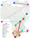
Geographical representation of the 15 geographic areas defined in the current study. These include six areas outside of continental Africa: E: the Mediterranean area; I: Asia; M: Madagascar; O: the Macaronesian area; P: the southern Arabian Peninsula; and R: the Americas. We defined nine areas within continental Africa (from north to south): L: the tropical African lowlands; T: the tropical Afromontane area; A: the tropical Afroalpine area; S: the southern African savannah; N: the arid to semi-arid southern African area; G: the southern African grasslands; D: the high Drakensberg area; C: the Indian Ocean coastal belt forest; and F: the Fynbos biome area. The dark green spots within the tropical Afromontane area are an overrepresentation of the tropical Afroalpine area. The colors and letters correspond to those in the biogeographical reconstruction (Figure 3).
Figure 3
Figure 3
Ancestral range estimation of the HAP clade using the best-fitting model DEC+j based on a time-calibrated phylogeny generated under the concatenation approach using target-enrichment data (Compositae1061 probe set). Pie charts at nodes show the relative probability of the possible states (areas in primary colors; combinations of areas in grey). Relevant node numbers are indicated to the left of the node. Black asterisks indicate nodes that were strongly supported by both metrics (BS and TBE ≥ 95%/0.95), grey asterisks indicate nodes strongly supported by only one metric (BS or TBE ≥ 95%/0.95), grey circles indicate nodes moderately supported by both metrics (BS and TBE from 70%/0.70 to 94%/0.94), and empty circles indicate nodes moderately supported by only one metric (BS or TBE from 70%/0.70 to 94%/0.94). Highlighted species correspond to tropical Afromontane clades in green, which include tropical Afroalpine clades in dark green (labelled as TA1, TA2, TA3); high Drakensberg species in brown; Malagasy species in magenta (main clades labelled as MAD1, MAD2, MAD3, MAD4). Other genera and large Malagasy clades are collapsed. The complete tree obtained in this analysis is shown in Figure S2.
Figure 4
Figure 4
Summary of mean dispersal events estimated from 100 biogeographic stochastic mappings in Helichrysum (see all event counts in Table S8). Arrow tips indicate the directionality of the dispersals. Numbers on the arrows are the mean of dispersal event counts. Arrow thickness is proportional to the mean number of dispersals: gray arrows correspond to mean counts below 0.5 (for readability, only the ones involving the eastern African montane area are shown), black arrows represent mean dispersal events ranging from 0.5 to 4 counts, and red arrows show the most common dispersal pathways (mean above 4 counts).

Similar articles

Cited by

References

    1. Heald W.F. Sky Island. Van Nostrand; Princeton, NJ, USA: 1967.
    1. White F. The Afromontane region. In: Wegner M.J.A., editor. Biogeography and Ecology of Southern Africa. Volume 31. Springer; Dordrecht, The Netherlands: 1978. pp. 463–513. - DOI
    1. White F. Vegetation of Africa: A Descriptive Memoir to Accompany the UNESCO/AETFAT/UNSO Vegetation Map of Africa. UNESCO; Paris, France: 1983.
    1. Gehrke B., Linder H.P. Species richness, endemism and species composition in the tropical Afroalpine flora. Alp. Bot. 2014;124:165–177. doi: 10.1007/s00035-014-0132-0. - DOI
    1. Hedberg O. Evolution and speciation in a tropical high mountain flora. Biol. J. Linn. Soc. 1969;1:135–148. doi: 10.1111/j.1095-8312.1969.tb01816.x. - DOI

LinkOut - more resources