Land use scenarios, seasonality, and stream identity determine the water physicochemistry of tropical cloud forest streams
- PMID: 37304864
- PMCID: PMC10249630
- DOI: 10.7717/peerj.15487
Land use scenarios, seasonality, and stream identity determine the water physicochemistry of tropical cloud forest streams
Abstract
Background: Land use is a major factor determining stream water physicochemistry. However, most streams move from one land use type to another as they drain their watersheds. Here, we studied three land use scenarios in a tropical cloud forest zone in Mexico. We addressed three main goals, to: (1) assess how land use scenarios generate different patterns in stream physicochemical characteristics; (2) explore how seasonality (i.e., dry, dry-to-wet transition, and wet seasons) might result in changes to those patterns over the year; and (3) explore whether physicochemical patterns in different scenarios resulted in effects on biotic components (e.g., algal biomass).
Methods: We studied Tropical Mountain Cloud Forest streams in La Antigua watershed, Mexico. Streams drained different three scenarios, streams with (1) an upstream section draining forest followed by a pasture section (F-P), (2) an upstream section in pasture followed by a forest section (P-F), and (3) an upstream forest section followed by coffee plantation (F-C). Physicochemistry was determined at the upstream and downstream sections, and at the boundary between land uses. Measurements were seasonal, including temperature, dissolved oxygen, conductivity, and pH. Water was analyzed for suspended solids, alkalinity, silica, chloride, sulfate, magnesium, sodium, and potassium. Nutrients included ammonium, nitrate, and phosphorus. We measured benthic and suspended organic matter and chlorophyll.
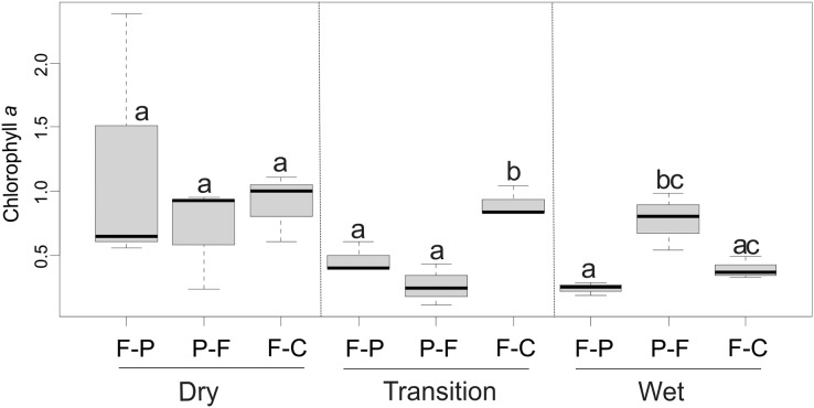
Results: Streams presented strong seasonality, with the highest discharge and suspended solids during the wet season. Scenarios and streams within each scenario had distinct physicochemical signatures. All three streams within each scenario clustered together in ordination space and remained close to each other during all seasons. There were significant scenario-season interactions on conductivity (F = 9.5, P < 0.001), discharge (F = 56.7, P < 0.001), pH (F = 4.5, P = 0.011), Cl- (F = 12.2, P < 0.001), SO42- (F = 8.8, P < 0.001) and NH4+ (F = 5.4, P = 0.005). Patterns within individual scenarios were associated with stream identity instead of land use. Both P-F and F-C scenarios had significantly different physicochemical patterns from those in F-P in all seasons (Procrustes analysis, m12 = 0.05-0.25; R = 0.86-0.97; P < 0.05). Chlorophyll was significantly different among scenarios and seasons (F = 5.36, P = 0.015, F = 3.81, P = 0.42, respectively). Concentrations were related to physicochemical variables more strongly during the transition season.
Conclusion: Overall, land use scenarios resulted in distinctive water physicochemical signatures highlighting the complex effects that anthropogenic activities have on tropical cloud forest streams. Studies assessing the effect of land use on tropical streams will benefit from assessing scenarios, rather than focusing on individual land use types. We also found evidence of the importance that forest fragments play in maintaining or restoring stream water physicochemistry.
Keywords: Cloud forest; Land use; Land use scenarios; Seasonality; Stream physicochemistry; Tropical streams.
© 2023 Vázquez et al.
Conflict of interest statement
The authors declare that they have no competing interests.
Figures


Similar articles
-
Does the diversity of vegetation and diatoms correlate with soil and water factors in a tropical cloud forest's complex land use/land cover scenario?Environ Monit Assess. 2024 Sep 10;196(10):916. doi: 10.1007/s10661-024-13072-5. Environ Monit Assess. 2024. PMID: 39254906
-
Taxonomic and functional responses of macroinvertebrates to riparian forest conversion in tropical streams.Sci Total Environ. 2021 Feb 25;757:143972. doi: 10.1016/j.scitotenv.2020.143972. Epub 2020 Dec 1. Sci Total Environ. 2021. PMID: 33321337
-
[Leaf litter decomposition in six Cloud Forest streams of the upper La Antigua watershed, Veracruz, Mexico].Rev Biol Trop. 2014 Apr;62 Suppl 2:111-27. Rev Biol Trop. 2014. PMID: 25189073 Spanish.
-
Patterns in potassium dynamics in forest ecosystems.Ecol Lett. 2006 Apr;9(4):451-66. doi: 10.1111/j.1461-0248.2006.00891.x. Ecol Lett. 2006. PMID: 16623731 Review.
-
Invasion of temperate deciduous broadleaf forests by N-fixing tree species - consequences for stream ecosystems.Biol Rev Camb Philos Soc. 2021 Jun;96(3):877-902. doi: 10.1111/brv.12682. Epub 2021 Jan 10. Biol Rev Camb Philos Soc. 2021. PMID: 33426804 Review.
Cited by
-
Stream food webs in tropical mountains rely on allochthonous carbon regardless of land use.PLoS One. 2023 Dec 15;18(12):e0295738. doi: 10.1371/journal.pone.0295738. eCollection 2023. PLoS One. 2023. PMID: 38100504 Free PMC article.
References
-
- Allan JD. Landscapes and riverscapes: the influence of land use on stream ecosystems. Annual Review of Ecology, Evolution, and Systematics. 2004;35(1):257–284. doi: 10.1146/annurev.ecolsys.35.120202.110122. - DOI
-
- APHA . Standard methods for the examination of water and wastewaters. Washington D. C.: American Public Health Association; 2005. p. 1368.
-
- Benstead JP, Douglas MM, Pringle CM. Relationships of stream invertebrate communities to deforestation in eastern Madagascar. Ecological Applications. 2003;13(5):1473–1490. doi: 10.1890/02-5125. - DOI
-
- Bleich ME, Mortati AF, André T, Piedade MTF. Riparian deforestation affects the structural dynamics of headwater streams in Southern Brazilian Amazonia. Tropical Conservation Science. 2014;7(4):657–676. doi: 10.1177/194008291400700406. - DOI
Publication types
MeSH terms
Substances
LinkOut - more resources
Full Text Sources