

The spatio-temporal distribution of acute encephalitis syndrome and its association with climate and landcover in Vietnam
- PMID: 37312047
- PMCID: PMC10262680
- DOI: 10.1186/s12879-023-08300-1
The spatio-temporal distribution of acute encephalitis syndrome and its association with climate and landcover in Vietnam
Abstract
Background: Acute encephalitis syndrome (AES) differs in its spatio-temporal distribution in Vietnam with the highest incidence seen during the summer months in the northern provinces. AES has multiple aetiologies, and the cause remains unknown in many cases. While vector-borne disease such as Japanese encephalitis and dengue virus and non-vector-borne diseases such as influenza and enterovirus show evidence of seasonality, associations with climate variables and the spatio-temporal distribution in Vietnam differs between these. The aim of this study was therefore to understand the spatio-temporal distribution of, and risk factors for AES in Vietnam to help hypothesise the aetiology.
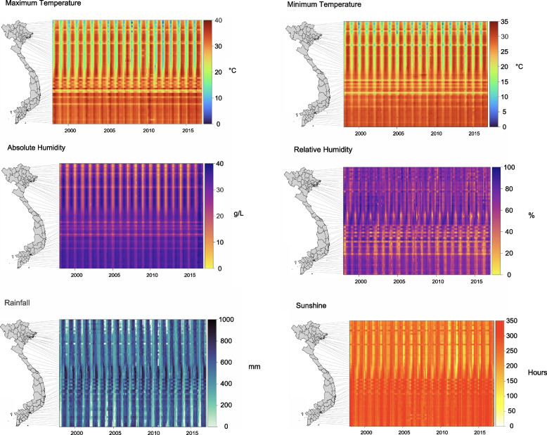
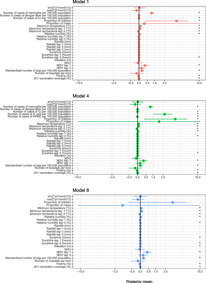
Methods: The number of monthly cases per province for AES, meningitis and diseases including dengue fever; influenza-like-illness (ILI); hand, foot, and mouth disease (HFMD); and Streptococcus suis were obtained from the General Department for Preventive Medicine (GDPM) from 1998-2016. Covariates including climate, normalized difference vegetation index (NDVI), elevation, the number of pigs, socio-demographics, JEV vaccination coverage and the number of hospitals were also collected. Spatio-temporal multivariable mixed-effects negative binomial Bayesian models with an outcome of the number of cases of AES, a combination of the covariates and harmonic terms to determine the magnitude of seasonality were developed.
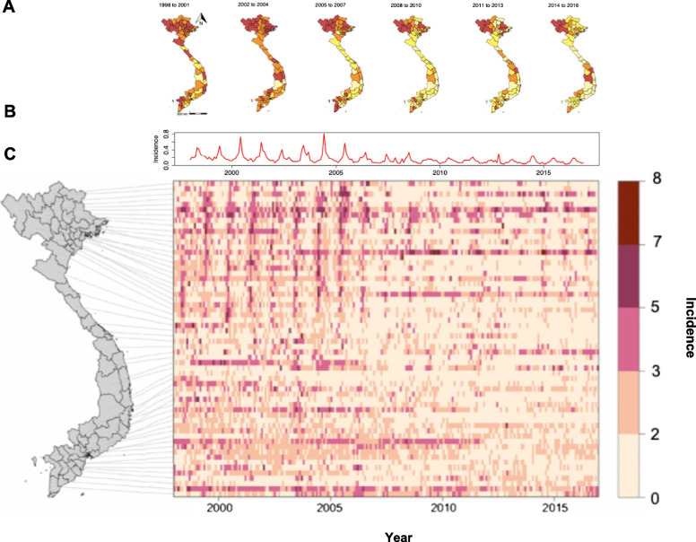
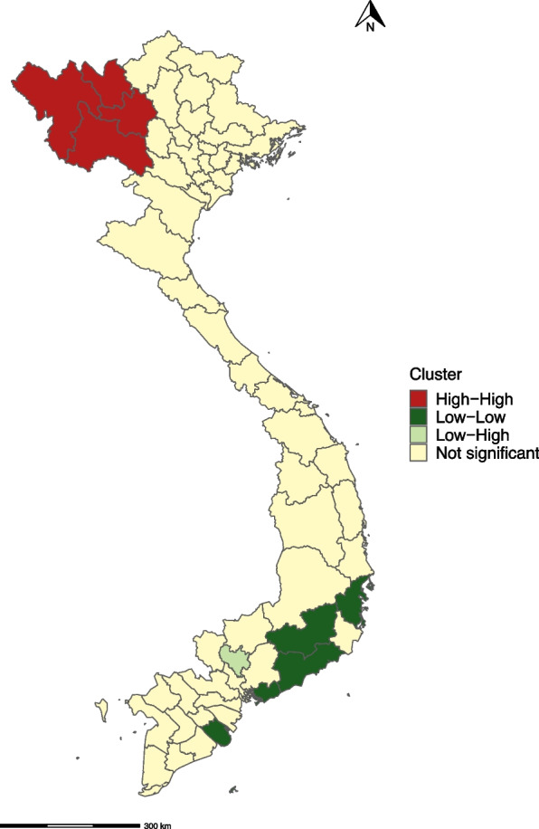
Results: The national monthly incidence of AES declined by 63.3% over the study period. However, incidence increased in some provinces, particularly in the Northwest region. In northern Vietnam, the incidence peaked in the summer months in contrast to the southern provinces where incidence remained relatively constant throughout the year. The incidence of meningitis, ILI and S. suis infection; temperature, relative humidity with no lag, NDVI at a lag of one month, and the number of pigs per 100,000 population were positively associated with the number of cases of AES in all models in which these covariates were included.
Conclusions: The positive correlation of AES with temperature and humidity suggest that a number of cases may be due to vector-borne diseases, suggesting a need to focus on vaccination campaigns. However, further surveillance and research are recommended to investigate other possible aetiologies such as S. suis or Orientia tsutsugamushi.
Keywords: Climate; Encephalitis; Spatio-temporal; Vaccination; Vegetation; Vietnam.
© 2023. The Author(s).
Conflict of interest statement
The authors declare no competing interests.
Figures
Similar articles
-
Bayesian spatio-temporal modelling of environmental, climatic, and socio-economic influences on malaria in Central Vietnam.Malar J. 2024 Aug 24;23(1):258. doi: 10.1186/s12936-024-05074-y. Malar J. 2024. PMID: 39182127 Free PMC article.
-
The Outbreaks of Acute Encephalitis Syndrome in Uttar Pradesh, India (1978-2020) and Its Effective Management: A Remarkable Public Health Success Story.Front Public Health. 2022 Feb 9;9:793268. doi: 10.3389/fpubh.2021.793268. eCollection 2021. Front Public Health. 2022. PMID: 35223759 Free PMC article. Review.
-
Does sunlight drive seasonality of TB in Vietnam? A retrospective environmental ecological study of tuberculosis seasonality in Vietnam from 2010 to 2015.BMC Infect Dis. 2020 Feb 28;20(1):184. doi: 10.1186/s12879-020-4908-0. BMC Infect Dis. 2020. PMID: 32111195 Free PMC article.
-
Characterization of regional influenza seasonality patterns in China and implications for vaccination strategies: spatio-temporal modeling of surveillance data.PLoS Med. 2013 Nov;10(11):e1001552. doi: 10.1371/journal.pmed.1001552. Epub 2013 Nov 19. PLoS Med. 2013. PMID: 24348203 Free PMC article.
-
Investigations of seasonal outbreaks of acute encephalitis syndrome due to Orientia tsutsugamushi in Gorakhpur region, India: A One Health case study.Indian J Med Res. 2021 Mar;153(3):375-381. doi: 10.4103/ijmr.IJMR_625_21. Indian J Med Res. 2021. PMID: 33907001 Free PMC article. Review.
Cited by
-
Clinical Profile and Long-Term Outcomes of Scrub Typhus Meningoencephalitis in Children.Cureus. 2025 Feb 15;17(2):e79055. doi: 10.7759/cureus.79055. eCollection 2025 Feb. Cureus. 2025. PMID: 40099080 Free PMC article.
-
Review of the aetiologies of central nervous system infections in Vietnam.Front Public Health. 2025 Jan 31;12:1396915. doi: 10.3389/fpubh.2024.1396915. eCollection 2024. Front Public Health. 2025. PMID: 39959908 Free PMC article.
-
Study on the temporal and spatial distribution of Culex mosquitoes in Hanoi, Vietnam.Sci Rep. 2024 Jul 17;14(1):16573. doi: 10.1038/s41598-024-67438-3. Sci Rep. 2024. PMID: 39020003 Free PMC article.
References
-
- Ministry of Health General Department of Preventive Medicine . Case definition of infectious disease. 2015.
-
- Trang PM, Rocklöv J, Giang KB, Kullgren G, Nilsson M. Heatwaves and Hospital Admissions for Mental Disorders in Northern Vietnam. PLoS One. 2016;11(5). Available from: https://www.ncbi.nlm.nih.gov/pmc/articles/PMC4873187/ [Cited 2021 Apr 5]. - PMC - PubMed
MeSH terms
Grants and funding
LinkOut - more resources
Full Text Sources
Medical
