

Estimating vaccine coverage in conflict settings using geospatial methods: a case study in Borno state, Nigeria
- PMID: 37422502
- PMCID: PMC10329660
- DOI: 10.1038/s41598-023-37947-8
Estimating vaccine coverage in conflict settings using geospatial methods: a case study in Borno state, Nigeria
Abstract
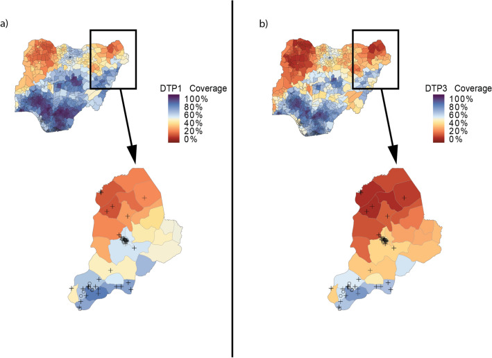
Reliable estimates of subnational vaccination coverage are critical to track progress towards global immunisation targets and ensure equitable health outcomes for all children. However, conflict can limit the reliability of coverage estimates from traditional household-based surveys due to an inability to sample in unsafe and insecure areas and increased uncertainty in underlying population estimates. In these situations, model-based geostatistical (MBG) approaches offer alternative coverage estimates for administrative units affected by conflict. We estimated first- and third-dose diphtheria-tetanus-pertussis vaccine coverage in Borno state, Nigeria, using a spatiotemporal MBG modelling approach, then compared these to estimates from recent conflict-affected, household-based surveys. We compared sampling cluster locations from recent household-based surveys to geolocated data on conflict locations and modelled spatial coverage estimates, while also investigating the importance of reliable population estimates when assessing coverage in conflict settings. These results demonstrate that geospatially-modelled coverage estimates can be a valuable additional tool to understand coverage in locations where conflict prevents representative sampling.
© 2023. The Author(s).
Conflict of interest statement
This study was funded by the Bill & Melinda Gates Foundation and Gavi, the Vaccine Alliance. The funders had no contribution to study design, data collection, data analysis, data interpretation, or writing of the manuscript. The corresponding author had full access to all data and results, as well as final responsibility for the decision to submit for publication. A.N.S., E.H., K.K., S.M., B.P., and J.F.M. report support from the Bill & Melinda Gates Foundation during the conduct of the study. Additionally, J.F.M. also reports support from Gavi, the Vaccine Alliance.
Figures


References
-
- ACLED. ACLEDhttps://acleddata.com/.
Publication types
MeSH terms
Substances
LinkOut - more resources
Full Text Sources
Medical
