

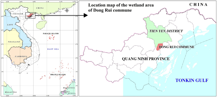
Assessment of fluctuations in wetland ecosystem areas resulting from anthropogenic activities in the Dong Rui commune, Quang Ninh Province, Vietnam
- PMID: 37484308
- PMCID: PMC10361022
- DOI: 10.1016/j.heliyon.2023.e16984
Assessment of fluctuations in wetland ecosystem areas resulting from anthropogenic activities in the Dong Rui commune, Quang Ninh Province, Vietnam
Abstract
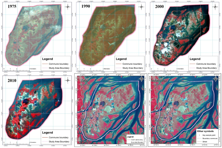
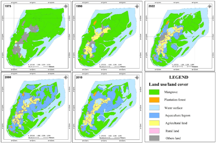
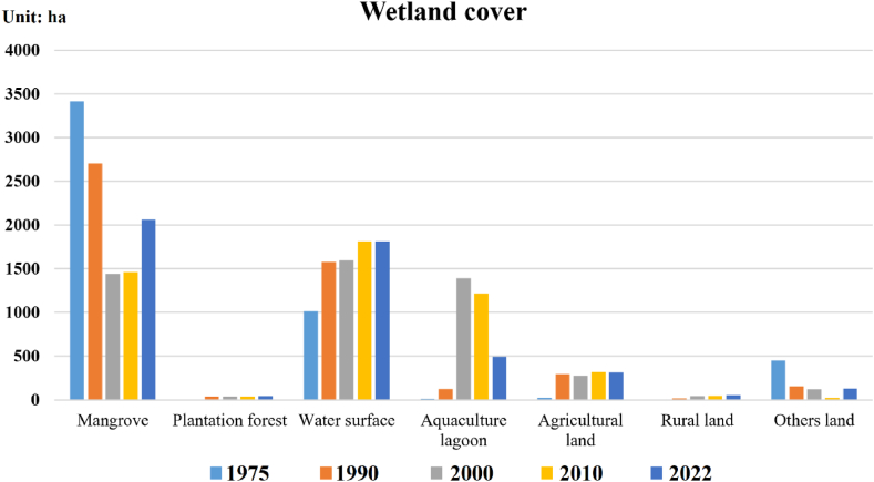
Wetlands are one of the most important ecosystems as habitats for many animal and plant species and are crucial for disaster mitigation, improving environmental quality, storing carbon, and responding to climate change. However, these sensitive ecosystems have been heavily affected by anthropogenic activities, including aquaculture. In this study, we used multitemporal satellite imagery integrated with a verified field survey method to map the coverage of the wetland ecosystem in the Dong Rui commune, Tien Yen district, Quang Ninh Province, Vietnam, five times for four periods from 1975 to 2022, with high accuracy (overall accuracy = 92.3%, Kappa = 0.91). The results showed that from 1975 to 2000, the area of mangrove forests declined sharply (by nearly 2,000 ha), mainly due to policies of development and conversion of land use. From 2000 to 2022, the mangrove forest area was gradually restored, while the area under aquaculture shrank. Anthropogenic impacts, especially the effects of local economic development, and conservation and developmental policies, are the main causes of continuous change in each short period. Our study demonstrates satellite imagery as an effective tool for assessing wetland ecosystem area fluctuations and assessing the extent of human impacts on this natural ecosystem. Our findings can serve as a basis for planning, conservation strategies, and sustainable development of wetland ecosystems and for improving the associated livelihoods of the communities.
Keywords: Anthropogenic activity; Mangrove forests; Mapping; Policy; Variability of cover area; Wetland.
© 2023 The Authors. Published by Elsevier Ltd.
Conflict of interest statement
The authors declare that they have no known competing financial interests or personal relationships that could have appeared to influence the work reported in this paper.
Figures
Similar articles
-
Mapping tree species of wetlands using multispectral images of UAVs and machine learning: A case study of the Dong Rui Commune.Heliyon. 2024 Jul 25;10(15):e35159. doi: 10.1016/j.heliyon.2024.e35159. eCollection 2024 Aug 15. Heliyon. 2024. PMID: 39157325 Free PMC article.
-
Impacts of land use on Indian mangrove forest carbon stocks: Implications for conservation and management.Ecol Appl. 2016 Jul;26(5):1396-1408. doi: 10.1890/15-2143. Ecol Appl. 2016. PMID: 27755754
-
Mangrove blue carbon stocks and dynamics are controlled by hydrogeomorphic settings and land-use change.Glob Chang Biol. 2020 May;26(5):3028-3039. doi: 10.1111/gcb.15056. Epub 2020 Mar 24. Glob Chang Biol. 2020. PMID: 32112604 Free PMC article.
-
The impacts of mangrove range expansion on wetland ecosystem services in the southeastern United States: Current understanding, knowledge gaps, and emerging research needs.Glob Chang Biol. 2022 May;28(10):3163-3187. doi: 10.1111/gcb.16111. Epub 2022 Feb 17. Glob Chang Biol. 2022. PMID: 35100489 Review.
-
Vulnerability and impacts of climate change on forest and freshwater wetland ecosystems in Nepal: A review.Ambio. 2017 Dec;46(8):915-930. doi: 10.1007/s13280-017-0923-9. Epub 2017 Jun 1. Ambio. 2017. PMID: 28573600 Free PMC article. Review.
Cited by
-
Mapping tree species of wetlands using multispectral images of UAVs and machine learning: A case study of the Dong Rui Commune.Heliyon. 2024 Jul 25;10(15):e35159. doi: 10.1016/j.heliyon.2024.e35159. eCollection 2024 Aug 15. Heliyon. 2024. PMID: 39157325 Free PMC article.
References
-
- Boerner R. Ecology and our endangered life-support systems. J. Environ. Qual. 1990;19:350–351. doi: 10.2134/jeq1990.00472425001900020028x. - DOI
-
- Wantzen, et al. In: Encyclopedia of Inland Waters. second ed. Mehner T., Tockner K., editors. Elsevier; Amsterdam: 2022. Carbon dynamics in wetlands; pp. 169–181. - DOI
LinkOut - more resources
Full Text Sources
