. 2023 Sep;7(9):1388-1397.
doi: 10.1038/s41559-023-02122-9. Epub 2023 Jul 24.

Carbonate compensation depth drives abyssal biogeography in the northeast Pacific

Affiliations

Carbonate compensation depth drives abyssal biogeography in the northeast Pacific

Erik Simon-Lledó et al. Nat Ecol Evol. 2023 Sep.

Abstract

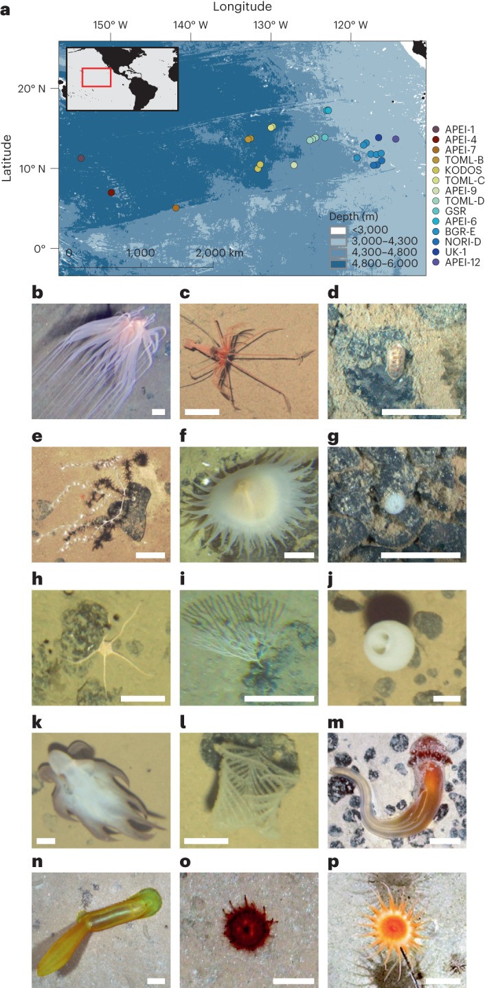
Abyssal seafloor communities cover more than 60% of Earth's surface. Despite their great size, abyssal plains extend across modest environmental gradients compared to other marine ecosystems. However, little is known about the patterns and processes regulating biodiversity or potentially delimiting biogeographical boundaries at regional scales in the abyss. Improved macroecological understanding of remote abyssal environments is urgent as threats of widespread anthropogenic disturbance grow in the deep ocean. Here, we use a new, basin-scale dataset to show the existence of clear regional zonation in abyssal communities across the 5,000 km span of the Clarion-Clipperton Zone (northeast Pacific), an area targeted for deep-sea mining. We found two pronounced biogeographic provinces, deep and shallow-abyssal, separated by a transition zone between 4,300 and 4,800 m depth. Surprisingly, species richness was maintained across this boundary by phylum-level taxonomic replacements. These regional transitions are probably related to calcium carbonate saturation boundaries as taxa dependent on calcium carbonate structures, such as shelled molluscs, appear restricted to the shallower province. Our results suggest geochemical and climatic forcing on distributions of abyssal populations over large spatial scales and provide a potential paradigm for deep-sea macroecology, opening a new basis for regional-scale biodiversity research and conservation strategies in Earth's largest biome.


Conflict of interest statement

The authors declare no competing interests.

Figures

Fig. 1
Fig. 1. Study region in the northeast Pacific basin and examples of abyssal benthic megafauna typically encountered at different depth ranges.
a, Map of study locations surveyed using deep-sea robots (ROVs and AUVs). Points indicate locations (depths 3,900–5,300 m) where data from seabed imagery studies were collated from, aligned and reanalysed using standardized methodology for homogenous detectability and taxonomic identification of invertebrate benthic megafauna (animals >10 mm). The colour of the points follows a consistent scheme used to differentiate each site in the other figures. bp, Examples of abyssal Pacific metazoan megafauna morphotypes (including depth, site and code in standardized catalogue), ordered by depth. b, Relicanthus daphneae sp. inc. (3,914 m, APEI-12, REL_001). c, Bathystylodactylus echninus (4,005 m, APEI-6. DEC_009). d, Leptochiton sp. indet. (4,205 m, NORI-D, MOL_002). e, Bathygorgia profunda sp. inc. (4,050 m, APEI-6, ALC_004), growing attached to a fossilized Otodus megalodon shark tooth. f, Sicyonidae gen. indet. (4,247 m, BGR-E, ACT_002). g, Thenea sp. indet. (4,190 m, NORI-D, DES_021). h, Ophiosphalma glabrum sp. inc. (4,621 m, TOML-D, OPH_010). i, Bifaxariidae gen. indet. (4,210 m. BGR-E, BRY_012). j, Hyalonema clarioni sp. inc. (4,848 m, TOML-C, HEX_002). k, Grimpoteuthis sp. indet. (4,959 m, TOML-C, MOL_008). l, Abyssopathes lyra (4,770 m, TOML-B, ANT_002). m, Tergivelum sp. indet. (5,019 m, KODOS, HEM_005). n, Psychropotes sp. indet. (5,007 m, APEI-4, HOL_047). o, Kamptosoma abyssale sp. inc. (5,240 m. APEI-1, URC_010). p, Actinostolidae gen. indet. (4,620 m, APEI-9, ACT_088).
Fig. 2
Fig. 2. Variations in the taxonomic composition of invertebrate megafaunal communities demarking biogeographic provinces within the northeast Pacific abyss.
a,b, Two-dimensional representation of multidimensional scaling analyses, depicting assemblage Bray–Curtis dissimilarity rates (distance) calculated between 161 independent community samples (containing 200 specimens identified to morphotype level per sample) across 28 geographical locations. a,b, Sample point colour coding: study site of each sample location (a) or mean depth at sample location (b). Arrow depicting the spatial extent of the carbonate compensation depth (CCD) across the northeast Pacific. Isotropic contour lines (fitted using GAMs) represent rough approximates of depth-range bins to aid visualization of patterns. c, Ridgeline plots outlining the geometric distribution of total abundance along depth for the dominant taxonomic groups in the abyssal CCZ megabenthos. On the y axis, frequency distribution relative to all the specimen occurrences sampled per group; colour, depth range (as depicted in b). d, Top four dominant taxonomic groups within the communities of different depth ranges (background seabed illustrating depth variation exaggerated across the region). ACT, Actiniaria; HOL, Holothuroidea; HEX, Hexactinellida; ANT, Antipatharia; ALC, Alcyonacea; OPH, Ophiuroidea; BRY, Bryozoa; and DEM, Demospongia. Note that depth was plotted decreasing from left to right, that is, west to east, to mirror the approximate spatial pattern across the CCZ.
Fig. 3
Fig. 3. Standing stocks were substantially larger in the shallow than in the deep-abyssal province while biodiversity rates were similar, although slightly increasing with depth, across the northeast Pacific abyss.
a,b, Faunal densities calculated in 84 independent community samples (containing 400–500 specimens) extending across 23 geographical locations. a,b, Variations in faunal density: between abyssal provinces (n = 41 samples in shallow, 27 in transition and 16 in the deep province) (a); and across the depth range (F1,82 = 51.61, P = 0.001, 2.81 × 10−10) (b). cf, Diversity estimates calculated in 161 independent community samples (containing 200 specimens identified to morphotype level per sample) extending across 28 geographical locations. c,d, Variations in morphotype richness (S): between abyssal provinces (n = 81 samples in shallow, 39 in transition and 41 in the deep province) (c); and across the depth range (F1,159 = 115.4, P = 2.2 × 10−16) (d). e,f, Variations in the exponential form of Shannon’s diversity index (expH’): between abyssal provinces (n = 81 samples in shallow, 39 in transition and 41 in the deep province) (e); and across the depth range (F1,159 = 94.09, P = 2.2 × 10−16) (f). g,h, Morphotype accumulation curves, showing variations in the total richness sampled: between provinces (dash-line: all data combined) (g); and between different sites (including only sites with more than three community samples) (h). a,d,e, Mean values (bars) and 95% confidence intervals (error bars) across all the samples in each province. b,d,f, Values calculated for each independent sample (points) and results of linear regression; mean (dashed-line) and 95% confidence intervals (shallowing). g,h, Mean values across 100 randomizations (lines) and 95% confidence intervals (shallowing). Note depth was plotted throughout decreasing from left to right, west to east, to mirror the approximate spatial pattern across the CCZ.

References

    1. Harris PT, Macmillan-Lawler M, Rupp J, Baker EK. Geomorphology of the oceans. Mar. Geol. 2014;352:4–24. doi: 10.1016/j.margeo.2014.01.011. - DOI
    1. Smith CR, De Leo FC, Bernardino AF, Sweetman AK, Arbizu PM. Abyssal food limitation, ecosystem structure and climate change. Trends Ecol. Evol. 2008;23:518–528. doi: 10.1016/j.tree.2008.05.002. - DOI - PubMed
    1. Yasuhara M, Danovaro R. Temperature impacts on deep-sea biodiversity. Biol. Rev. Camb. Philos. Soc. 2016;91:275–287. doi: 10.1111/brv.12169. - DOI - PubMed
    1. Aleynik D, Inall ME, Dale A, Vink A. Impact of remotely generated eddies on plume dispersion at abyssal mining sites in the Pacific. Sci. Rep. 2017;7:16959. doi: 10.1038/s41598-017-16912-2. - DOI - PMC - PubMed
    1. Rex MA, et al. Global bathymetric patterns of standing stock and body size in the deep-sea benthos. Mar. Ecol. Prog. Ser. 2006;317:1–8. doi: 10.3354/meps317001. - DOI

Publication types