Dead-reckoning elucidates fine-scale habitat use by European badgers Meles meles
- PMID: 37521810
- PMCID: PMC8908954
- DOI: 10.1186/s40317-022-00282-2
Dead-reckoning elucidates fine-scale habitat use by European badgers Meles meles
Abstract
Background: Recent developments in both hardware and software of animal-borne data loggers now enable large amounts of data to be collected on both animal movement and behaviour. In particular, the combined use of tri-axial accelerometers, tri-axial magnetometers and GPS loggers enables animal tracks to be elucidated using a procedure of 'dead-reckoning'. Although this approach was first suggested 30 years ago by Wilson et al. (1991), surprisingly few measurements have been made in free-ranging terrestrial animals. The current study examines movements, interactions with habitat features, and home-ranges calculated from just GPS data and also from dead-reckoned data in a model terrestrial mammal, the European badger (Meles meles).
Methods: Research was undertaken in farmland in Northern Ireland. Two badgers (one male, one female) were live-trapped and fitted with a GPS logger, a tri-axial accelerometer, and a tri-axial magnetometer. Thereafter, the badgers' movement paths over 2 weeks were elucidated using just GPS data and GPS-enabled dead-reckoned data, respectively.
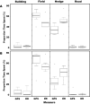
Results: Badgers travelled further using data from dead-reckoned calculations than using the data from only GPS data. Whilst once-hourly GPS data could only be represented by straight-line movements between sequential points, the sub-second resolution dead-reckoned tracks were more tortuous. Although there were no differences in Minimum Convex Polygon determinations between GPS- and dead-reckoned data, Kernel Utilisation Distribution determinations of home-range size were larger using the former method. This was because dead-reckoned data more accurately described the particular parts of landscape constituting most-visited core areas, effectively narrowing the calculation of habitat use. Finally, the dead-reckoned data showed badgers spent more time near to field margins and hedges than simple GPS data would suggest.
Conclusion: Significant differences emerge when analyses of habitat use and movements are compared between calculations made using just GPS data or GPS-enabled dead-reckoned data. In particular, use of dead-reckoned data showed that animals moved 2.2 times farther, had better-defined use of the habitat (revealing clear core areas), and made more use of certain habitats (field margins, hedges). Use of dead-reckoning to provide detailed accounts of animal movement and highlight the minutiae of interactions with the environment should be considered an important technique in the ecologist's toolkit.
Keywords: Accelerometer; Badger; Dead-reckoning; Distance travelled; GPS; Home-range; Logger; Movement; Tuberculosis.
© The Author(s) 2022.
Conflict of interest statement
Competing interestsThe authors declare that they have no competing interests.
Figures


Similar articles
-
Impact of test, vaccinate or remove protocol on home ranges and nightly movements of badgers a medium density population.Sci Rep. 2023 Feb 14;13(1):2592. doi: 10.1038/s41598-023-28620-1. Sci Rep. 2023. PMID: 36788237 Free PMC article.
-
Step by step: reconstruction of terrestrial animal movement paths by dead-reckoning.Mov Ecol. 2015 Sep 15;3(1):23. doi: 10.1186/s40462-015-0055-4. eCollection 2015. Mov Ecol. 2015. PMID: 26380711 Free PMC article.
-
How often should dead-reckoned animal movement paths be corrected for drift?Anim Biotelemetry. 2021 Oct 16;9:43. doi: 10.1186/s40317-021-00265-9. Anim Biotelemetry. 2021. PMID: 34900262 Free PMC article.
-
Can badger vaccination contribute to bovine TB control? A narrative review of the evidence.Prev Vet Med. 2025 May;238:106464. doi: 10.1016/j.prevetmed.2025.106464. Epub 2025 Feb 14. Prev Vet Med. 2025. PMID: 39983381 Review.
-
Mycobacterium bovis infection in the Eurasian badger (Meles meles): the disease, pathogenesis, epidemiology and control.J Comp Pathol. 2011 Jan;144(1):1-24. doi: 10.1016/j.jcpa.2010.10.003. Epub 2010 Dec 4. J Comp Pathol. 2011. PMID: 21131004 Review.
Cited by
-
Impact of test, vaccinate or remove protocol on home ranges and nightly movements of badgers a medium density population.Sci Rep. 2023 Feb 14;13(1):2592. doi: 10.1038/s41598-023-28620-1. Sci Rep. 2023. PMID: 36788237 Free PMC article.
-
A novel method for identifying fine-scale bottom-use in a benthic-foraging pinniped.Mov Ecol. 2023 Jun 9;11(1):34. doi: 10.1186/s40462-023-00386-1. Mov Ecol. 2023. PMID: 37296462 Free PMC article.
-
Landscape as a Shared Space for Badgers and Cattle: Insights Into Indirect Contact and Bovine Tuberculosis Transmission Risk.Ecol Evol. 2025 Apr 15;15(4):e71114. doi: 10.1002/ece3.71114. eCollection 2025 Apr. Ecol Evol. 2025. PMID: 40235730 Free PMC article.
-
Data-driven analysis of fine-scale badger movement in the UK.PLoS Comput Biol. 2025 Aug 28;21(8):e1013372. doi: 10.1371/journal.pcbi.1013372. eCollection 2025 Aug. PLoS Comput Biol. 2025. PMID: 40875649 Free PMC article.
-
Increasingly detailed insights in animal behaviours using continuous on-board processing of accelerometer data.Mov Ecol. 2022 Oct 24;10(1):42. doi: 10.1186/s40462-022-00341-6. Mov Ecol. 2022. PMID: 36280879 Free PMC article.
References
-
- Ropert-Coudert Y, Wilson RP. Trends and perspectives in animal-attached remote sensing. Front Ecol Environ. 2005;3(8):437–44.
-
- Kays R, Crofoot MC, Jetz W, Wikelski M. Terrestrial animal tracking as an eye on life and planet. Science. 2015;348:6240. - PubMed
-
- Chung H, Lee J, Lee WJ. A review: marine bio-logging of animal behaviour and ocean environments. Ocean Sci J. 2021;2021(56):117–31.
-
- Brown DD, Kays R, Wikelski M, Wilson R, Klimley AP. Observing the unwatchable through acceleration logging of animal behavior. Anim Biotelem. 2013;1(1):20.
-
- Wilson RP, Wilson MP, Link R, Mempel H, Adams NJ. Determination of movements of African penguins Spheniscus demersus using a compass system: dead-reckoning may be an alternative to telemetry. J Exp Biol. 1991;157(1):557–64.
LinkOut - more resources
Full Text Sources
