

Geo-spatial high-risk clusters of Tuberculosis in the global general population: a systematic review
- PMID: 37598144
- PMCID: PMC10439548
- DOI: 10.1186/s12889-023-16493-y
Geo-spatial high-risk clusters of Tuberculosis in the global general population: a systematic review
Abstract
Introduction: The objective of this systematic review is to identify tuberculosis (TB) high-risk among the general population globally. The review was conducted using the following steps: elaboration of the research question, search for relevant publications, selection of studies found, data extraction, analysis, and evidence synthesis.
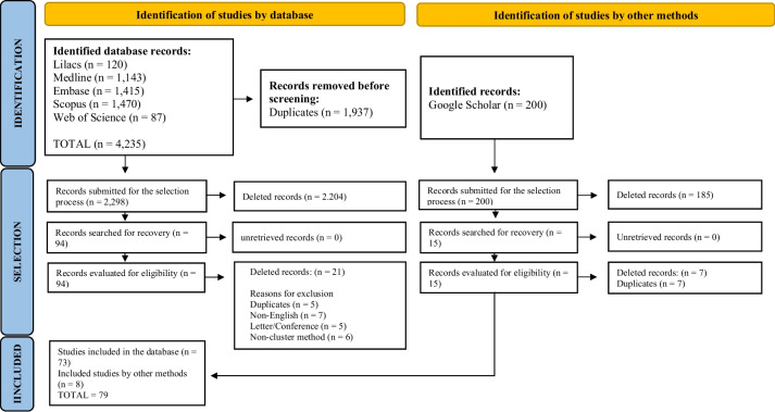
Methods: The studies included were those published in English, from original research, presented findings relevant to tuberculosis high-risk across the globe, published between 2017 and 2023, and were based on geospatial analysis of TB. Two reviewers independently selected the articles and were blinded to each other`s comments. The resultant disagreement was resolved by a third blinded reviewer. For bibliographic search, controlled and free vocabularies that address the question to be investigated were used. The searches were carried out on PubMed, LILACS, EMBASE, Scopus, and Web of Science. and Google Scholar.
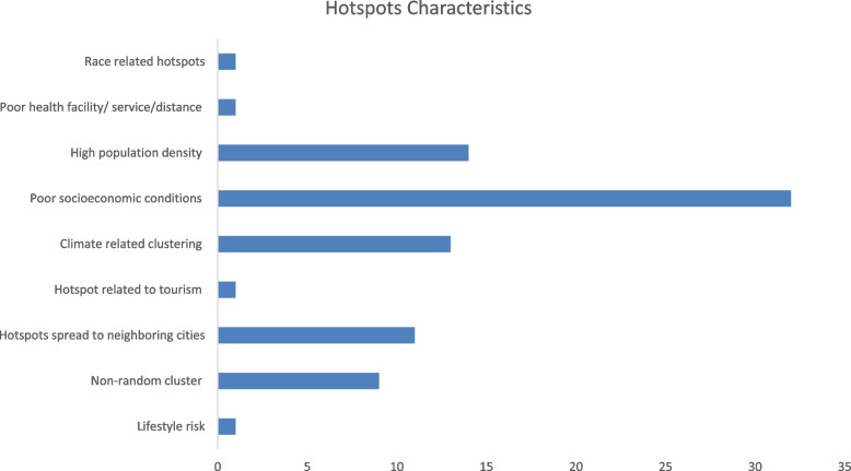
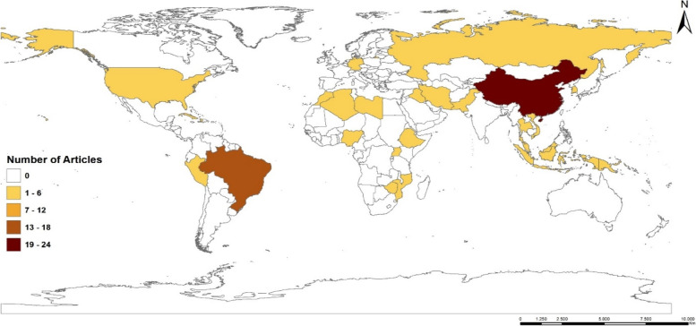
Results: A total of 79 published articles with a 40-year study period between 1982 and 2022 were evaluated. Based on the 79 studies, more than 40% of all countries that have carried out geospatial analysis of TB were from Asia, followed by South America with 23%, Africa had about 15%, and others with 2% and 1%. Various maps were used in the various studies and the most used is the thematic map (32%), rate map (26%), map of temporal tendency (20%), and others like the kernel density map (6%). The characteristics of the high-risk and the factors that affect the hotspot's location are evident through studies related to poor socioeconomic conditions constituting (39%), followed by high population density (17%), climate-related clustering (15%), high-risk spread to neighbouring cities (13%), unstable and non-random cluster (11%).
Conclusion: There exist specific high-risk for TB which are areas that are related to low socioeconomic conditions and spectacular weather conditions, these areas when well-known will be easy targets for intervention by policymakers. We recommend that more studies making use of spatial, temporal, and spatiotemporal analysis be carried out to point out territories and populations that are vulnerable to TB.
Keywords: High-risk; Spatial analysis, High-risk cluster; Spatiotemporal analysis; Tuberculosis.
© 2023. BioMed Central Ltd., part of Springer Nature.
Conflict of interest statement
The authors declare no competing interests.
Figures
References
-
- WHO WORLD health Organization 2018 https://apps.who.int/iris/bitstream/handle/10665/329368/9789241565 714-eng.pdf. Accessed 28 Sep 2022.
-
- WHO, 2013 WORLD health Organization; 2019. https://apps.who.int/iris/bitstream/handle/10665/329368/9789241565 714-eng.pdf. Accessed 28 Sep 2022.
-
- Maher D. The natural history of Mycobacterium tuberculosis infection in adults. In: Schaaf HS, Zumla A, editors. Tuberculosis: A comprehensive clinical reference. UK: Elsevier Health Sciences; 2009. pp. 129–132.
-
- WHO – World Health Organization. 2020. Available to: https://apps.who.int/iris/bitstream/handle/10665/329368/9789241565714-en... . Accessed 11 Nov 2022.
Publication types
MeSH terms
LinkOut - more resources
Full Text Sources
Medical
