. 2023 Sep 22;14(1):5928.
doi: 10.1038/s41467-023-41668-x.

River interlinking alters land-atmosphere feedback and changes the Indian summer monsoon

Affiliations

River interlinking alters land-atmosphere feedback and changes the Indian summer monsoon

Tejasvi Chauhan et al. Nat Commun. .

Erratum in

Abstract

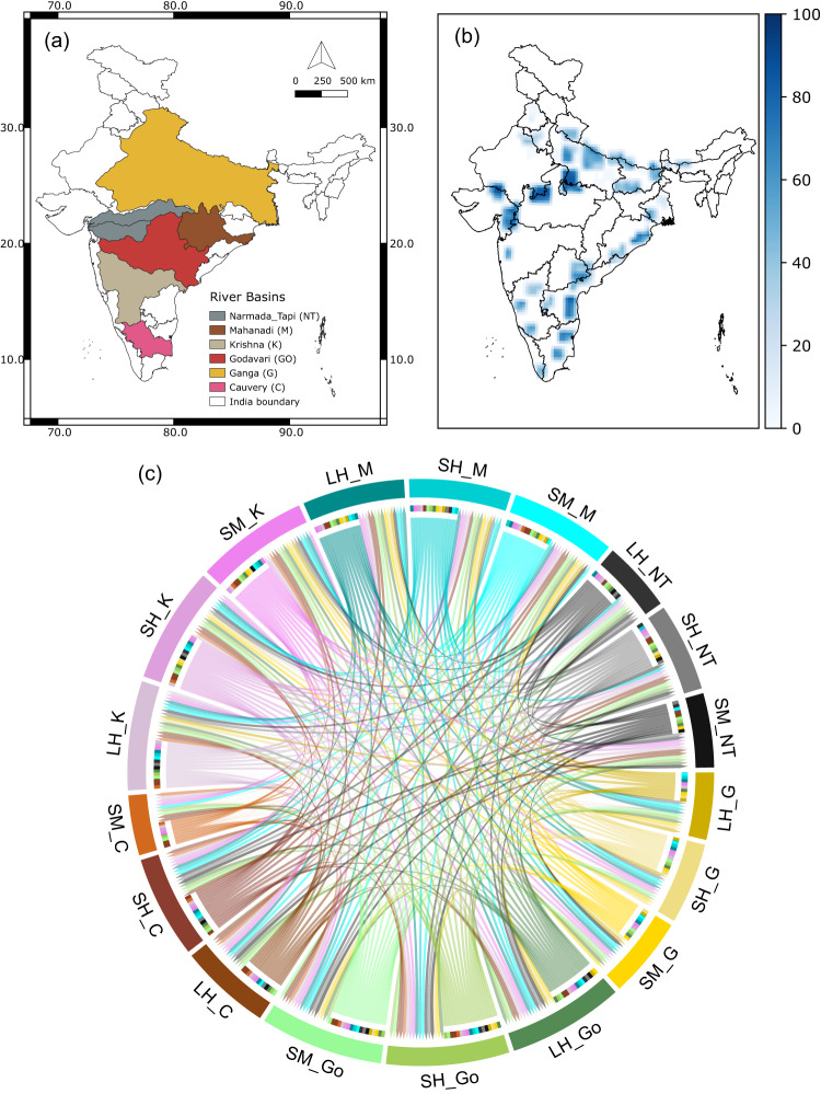
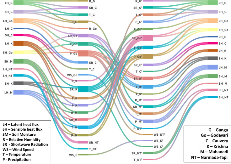
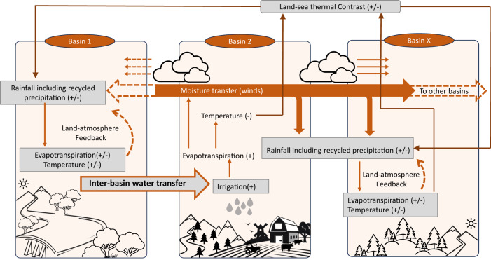
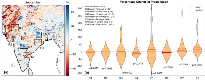
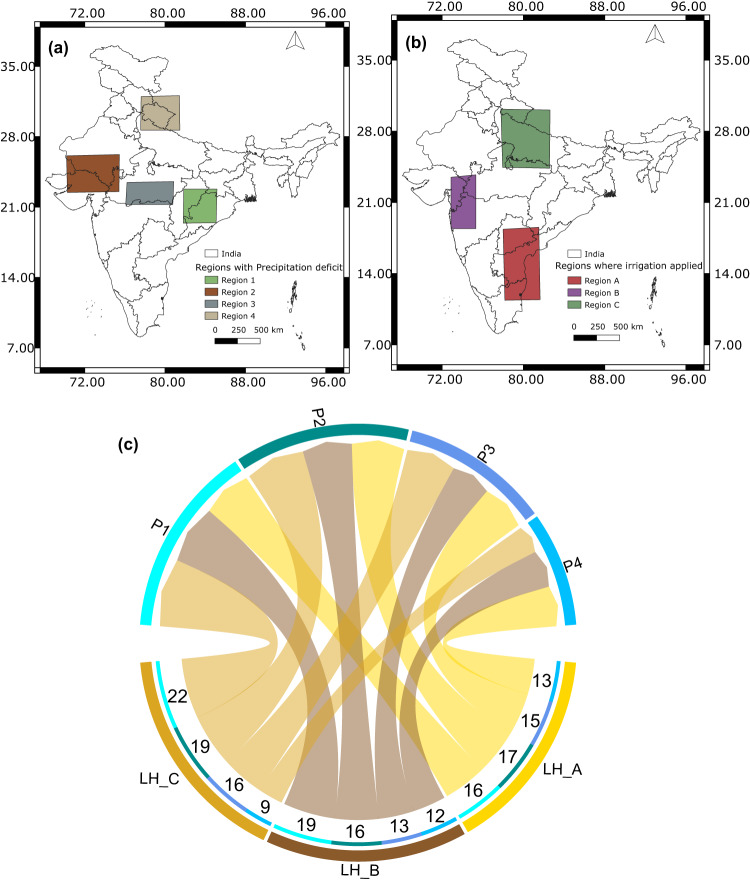
Massive river interlinking projects are proposed to offset observed increasing droughts and floods in India, the most populated country in the world. These projects involve water transfer from surplus to deficit river basins through reservoirs and canals without an in-depth understanding of the hydro-meteorological consequences. Here, we use causal delineation techniques, a coupled regional climate model, and multiple reanalysis datasets, and show that land-atmosphere feedbacks generate causal pathways between river basins in India. We further find that increased irrigation from the transferred water reduces mean rainfall in September by up to 12% in already water-stressed regions of India. We observe more drying in La Niña years compared to El Niño years. Reduced September precipitation can dry rivers post-monsoon, augmenting water stress across the country and rendering interlinking dysfunctional. Our findings highlight the need for model-guided impact assessment studies of large-scale hydrological projects across the globe.


Conflict of interest statement

The authors declare no competing interests.

Figures

Fig. 1
Fig. 1. Connections between land variables of different river basins.
a River Basins in India considered in the study. b Irrigated grid cells under river interlinking schemes showing change in percentage irrigated area from control run (CTL) to irrigation run (IRR) run (see “Methods”) to increase irrigated area fraction to 80%. c Network between land variable across river basins generated using the algorithm PCMCI (ParCorr). Sectors are labeled as variable symbols (soil moisture-SM, latent heat flux-LH, sensible heat flux-SH) followed by the basin they belong to (Ganga (G, 808,334 km2), Godavari (Go, 302,063 km2), Mahanadi (M, 139,659 km2), Krishna (K, 254,743 km2), Narmada-Tapi (NT, 98,796 km2, 65,145 km2, respectively—two river basins taken together), and Cauvery (C, 85,624 km2)). Links are only shown if found statistically significant at 99% confidence and are colored same as the node they originate from. For example, link from LH_G to LH_M shows that there is a connection between latent heat fluxes from Ganga and Mahanadi basin. Ratio of incoming to outgoing links in Cauvery basin is very high compared to Ganga and Narmada-Tapi basin.
Fig. 2
Fig. 2. Inter-basin connections via land-atmosphere feedback.
Connections using PCMCI from Land to atmosphere within basin (first column), between atmospheric variables across all basins (second column), and from atmosphere to land within the basin (third column). A link is shown only if it is found statistically significant at 5% level more than 50% of the time (20 years out of 40 years (1981–2020)). Names are variable symbols followed by the basin they belong to for example, LH_G means latent heat flux from Ganga basin. The first and second column of variables are land variables (soil moisture SM, latent heat flux LH, and sensible heat flux SH) and atmosphere variables (precipitation P, temperature T, relative humidity R, wind speed WS, and incoming short wave radiation SR), respectively, links between which represent land-to-atmosphere connections within each basin. Links between next two columns represent atmosphere to atmosphere connections, for example, there is a link from temperature in Ganga basin (T_Go) to that of Mahanadi basin (T_M’). Links in the last column represent downward connections from atmospheric variables to land variables within basin.
Fig. 3
Fig. 3. Schematic diagram explaining the land-atmosphere feedback and changes in monsoon rainfall in response to river-interlinking.
The perturbations in the land water management leading from the inter-basin water transfer impact the spatial pattern of rainfall on the distant basins. The intra-basin land-to-atmosphere connection happens in the form of soil moisture contributing to the moisture content of the air through evapotranspiration (high evapotranspiration during high soil moisture (SM)) while also causing surface cooling. The supplied moisture by evapotranspiration can lead to recycled precipitation in the same basin or can get transported to faraway regions by the wind, which can then change the precipitation patterns of the region. Evaporative cooling changes the thermal contrast between ocean and land or in between different land regions changing wind patterns and, subsequently, the moisture transport and rainfall.
Fig. 4
Fig. 4. Change in September precipitation after river-interlinking.
a Percentage change in mean daily precipitation between WRF irrigation run (IRR) and control run (CTL) (IRR-CTL) for the month of September. Hatch lines mark regions where the difference was found statistically significant at 90% confidence tested on 660 data points. b Violin plots of percentage change for all years in mean September rainfall for regions marked in (a). Median and mean change for all years are represented by red and black horizontal lines, respectively. Median percentage change is also written with the name of each region. There is a significant reduction in September precipitation of up to 12% in central (state of Madhya Pradesh), eastern (states of Odisha and Chhattisgarh), northern (state of Uttarakhand in western Himalaya), and western arid region (states of Rajasthan and Gujarat) of India.
Fig. 5
Fig. 5. Causal connections from river-interlinking to reduced precipitation.
a Selected regions where irrigation was applied in irrigation run (IRR). b Selected regions of September precipitation where drying is observed due to interlinking. c Connections form change in latent heat flux (IRR - control run (CTL)) in the irrigated regions to change in precipitation (IRR-CTL) in the highlighted regions using Transfer Entropy. Links are labeled as the number of years, when they were found out to be statistically significant (p < 0.05) out of 22 years of simulations (1991–2012). This shows that change in precipitation from CTL to IRR experiment is causally related to the corresponding change in latent heat flux of other regions indicating consistent land-atmosphere feedback.

References

    1. Jain, S. K., Agarwal, P. K. & Singh, V. P. Hydrology and Water Resources of India Vol. 57 (Springer Netherlands, 2007).
    1. Best J. Anthropogenic stresses on the world’s big rivers. Nat. Geosci. 2018;12:7–21. doi: 10.1038/s41561-018-0262-x. - DOI
    1. He C, et al. Future global urban water scarcity and potential solutions. Nat. Commun. 2021;12:4667. doi: 10.1038/s41467-021-25026-3. - DOI - PMC - PubMed
    1. Satoh Y, et al. Multi-model and multi-scenario assessments of Asian water futures: The Water Futures and Solutions (WFaS) initiative. Earth’s Future. 2017;5:823–852. doi: 10.1002/2016EF000503. - DOI
    1. Wada, Y. et al. Global monthly water stress: 2. Water demand and severity of water stress. Water Resour. Res.47, 7 (2011).