

Lateral river erosion impacts the preservation of Neolithic enclosures in alluvial plains
- PMID: 37783939
- PMCID: PMC10545758
- DOI: 10.1038/s41598-023-43849-6
Lateral river erosion impacts the preservation of Neolithic enclosures in alluvial plains
Abstract
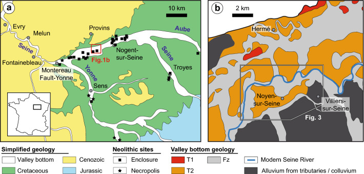
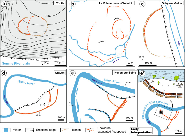
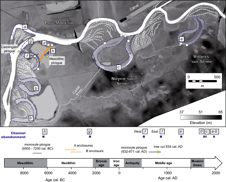
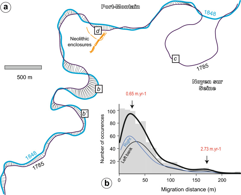
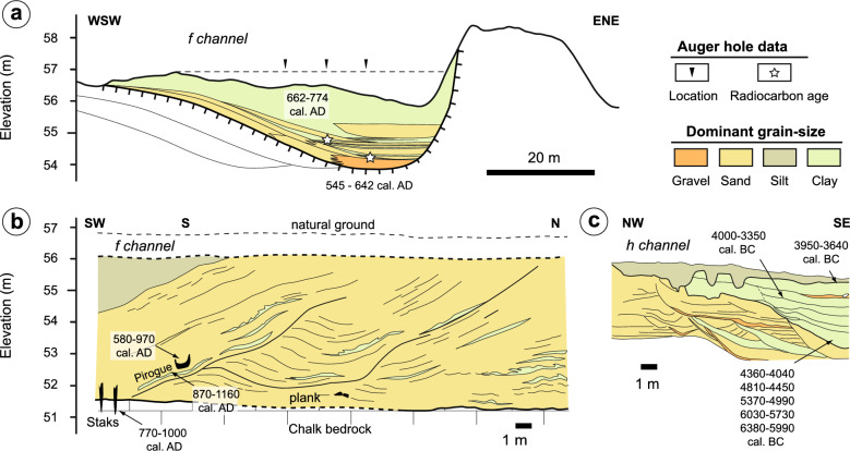
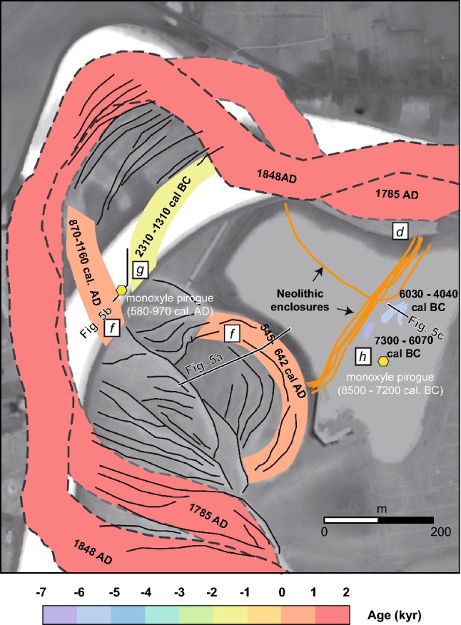
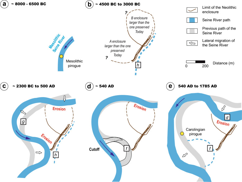
Situating prehistoric sites in their past environment helps us to understand their functionality and the organization of early sedentary human societies. However, this is a challenge as the natural environment constantly evolves through time and erases these constructions, especially along riverbanks, thus biasing the archaeological record. This study introduces a reassessment of the paleo-landscape evolution around the Neolithic enclosures at the Noyen-sur-Seine site based on new field observations as well as the synthesis of (un)published and new radiocarbon dating. Contrary to the initial hypothesis, our results show that the Noyen enclosures were not built along a Neolithic Seine River: the nearby channels were active in the Middle Age and Early Modern periods. Therefore, the results show that the enclosures were originally much larger: only a fraction that survived river erosion (lateral migration rates up to 2-3 m yr-1 estimated during the nineteenth century) has been preserved. Instead, an abandoned Mesolithic Seine River served as a natural delimitation of the SE part of the Neolithic enclosures. These results indicate that Neolithic enclosures in alluvial settings are often only partly preserved and that societies from that period lived farther away from active rivers than originally thought, where they were protected from floods.
© 2023. Springer Nature Limited.
Conflict of interest statement
The authors declare no competing interests.
Figures
Similar articles
-
Landscape development, forest fires, and wilderness management.Science. 1974 Nov 8;186(4163):487-95. doi: 10.1126/science.186.4163.487. Science. 1974. PMID: 17790369
-
Large-scale investigations of Neolithic settlement dynamics in Central Germany based on machine learning analysis: A case study from the Weiße Elster river catchment.PLoS One. 2022 Apr 20;17(4):e0265835. doi: 10.1371/journal.pone.0265835. eCollection 2022. PLoS One. 2022. PMID: 35442952 Free PMC article. Review.
-
Prehistoric human colonization of India.J Biosci. 2001 Nov;26(4 Suppl):491-531. doi: 10.1007/BF02704749. J Biosci. 2001. PMID: 11779962
-
Archaeological sites in Grand Canyon National Park along the Colorado River are eroding owing to six decades of Glen Canyon Dam operations.J Environ Manage. 2023 Sep 15;342:118036. doi: 10.1016/j.jenvman.2023.118036. Epub 2023 May 12. J Environ Manage. 2023. PMID: 37182479
-
Climate and land-use changes affecting river sediment and brown trout in alpine countries--a review.Environ Sci Pollut Res Int. 2009 Mar;16(2):232-42. doi: 10.1007/s11356-008-0075-3. Epub 2008 Dec 2. Environ Sci Pollut Res Int. 2009. PMID: 19048320 Review.
References
-
- Mordant C, Mordant D. Les Enceintes neolithiques de la Haute-Vallee de la Seine. Enclos. Def. Neolit. West Eur. BAR Int. Ser. 1988;403:231–254.
-
- Varndell G, Topping P. Enclosures in Neolithic Europe: Essays on Causewayed and Non-causewayed Sites. Oxbow Books; 2002.
-
- Parkinson WA, Duffy PR. Fortifications and enclosures in European prehistory: a cross-cultural perspective. J. Archaeol. Res. 2007;15:97–141. doi: 10.1007/s10814-007-9010-2. - DOI
-
- Lietar, C. The role of enclosures in territorial organization in the Paris Basin between 4500 and 3800 BC. Giants Landsc. Monum. Territ. Eur. Neolit. 31 (2016).
-
- Augereau A, Desbrosse V, Laurelut C, Mordant D. Genèse et évolution des enceintes du bassin Seine-Yonne au cours du Néolithique moyen et récent. Conseil départemental de l’Aube; Éditions Snoeck; 2021. pp. 144–157.
LinkOut - more resources
Full Text Sources
Miscellaneous
