Estimating County Level Health Indicators Using Spatial Microsimulation
- PMID: 37822803
- PMCID: PMC10564386
- DOI: 10.1002/psp.2647
Estimating County Level Health Indicators Using Spatial Microsimulation
Abstract
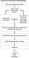
Given the importance of understanding health outcomes at fine spatial scales, iterative proportional fitting (IPF), a form of small area estimation, was applied to a fixed number of health-related variables (obesity, overweight, diabetes) taken from regionalized 2019 survey responses (n = 5474) from the Idaho Behavioral Risk Factor Surveillance System (BRFSS). Using associated county-level American Community Survey (ACS) census data, a set of constraints, which included age categorization, race, sex, and education level, were used to create county-level weighting matrices for each variable, for each of the seven (7) Idaho public health districts. Using an optimized modeling construction technique, we identified significant constraints and grouping splits for each variable/region, resulting in estimates that were internally and externally validated. Externally validated model results for the most populated counties showed correlations ranging from .79 to .85, with p values all below .05. Estimates indicated higher levels of obesity and overweight individuals for midsouth and southwestern Idaho counties, with a cluster of higher diabetes estimates in the center of the state (Gooding, Lincoln, Minidoka, and Jerome counties). Alternative external sources for health outcomes aligned extremely well with our estimates, with wider confidence intervals in more rural counties with sparse populations.
Keywords: Diabetes; Idaho; Iterative Proportional Fitting; Obesity; Overweight; Small Area Estimates.
Conflict of interest statement
Authors Conflicts of Interest There are no conflicts of interest.
Figures


References
-
- Adler NE and Newman K (2002). Socioeconomic disparities in health: Pathways and policies. Health Affairs, 21(2):60–76. - PubMed
-
- Agresti A and Coull BA (1998). Approximate is better than “Exact” for interval estimation of binomial proportions. American Statistician, 52(2):119–126.
-
- Ballas D, Clarke G, Dorling D, and Rossiter D (2007). Using SimBritain to model the geographical impact of national government policies. Geographical Analysis, 39(1):44–77.
-
- Ballas D, Clarke GP, and Wiemers E (2005). Building a dynamic spatial microsimulation model for Ireland. Population, Space and Place, 11(3):157–172.
-
- Bell J and Lee M (2011). Why Place and Race Matter: Impacting Health Through a Focus on Race and Place. Technical report, Policylink.
Grants and funding
LinkOut - more resources
Full Text Sources
