. 2023 Nov 9;13(1):19482.
doi: 10.1038/s41598-023-45559-5.

Expanding our view of the cold-water coral niche and accounting of the ecosystem services of the reef habitat

Affiliations

Expanding our view of the cold-water coral niche and accounting of the ecosystem services of the reef habitat

Erik E Cordes et al. Sci Rep. .

Abstract

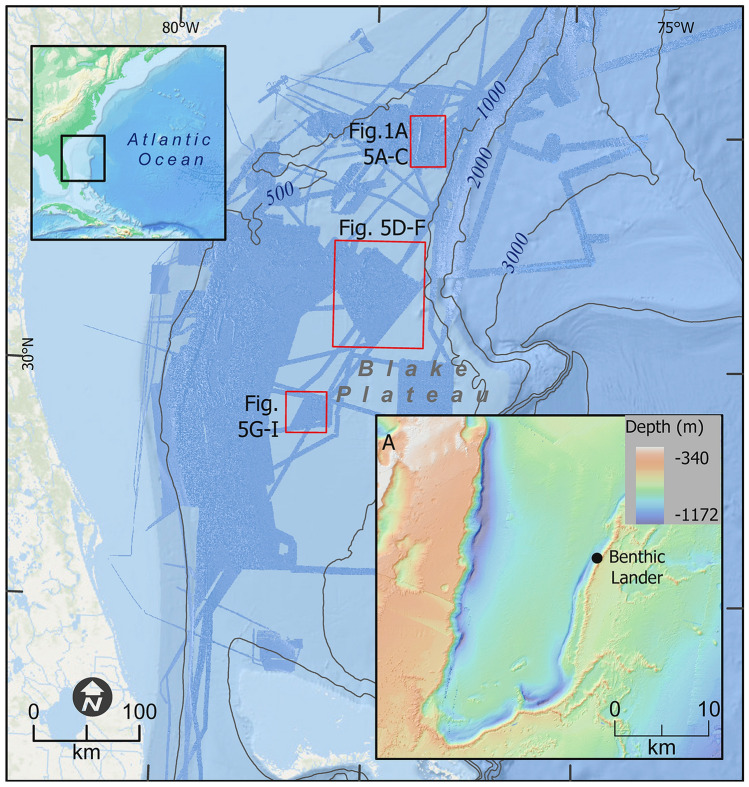
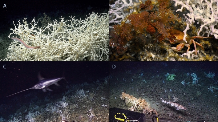
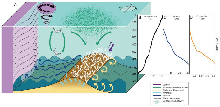
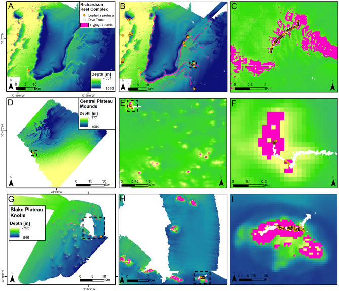
Coral reefs are iconic ecosystems that support diverse, productive communities in both shallow and deep waters. However, our incomplete knowledge of cold-water coral (CWC) niche space limits our understanding of their distribution and precludes a complete accounting of the ecosystem services they provide. Here, we present the results of recent surveys of the CWC mound province on the Blake Plateau off the U.S. east coast, an area of intense human activity including fisheries and naval operations, and potentially energy and mineral extraction. At one site, CWC mounds are arranged in lines that total over 150 km in length, making this one of the largest reef complexes discovered in the deep ocean. This site experiences rapid and extreme shifts in temperature between 4.3 and 10.7 °C, and currents approaching 1 m s-1. Carbon is transported to depth by mesopelagic micronekton and nutrient cycling on the reef results in some of the highest nitrate concentrations recorded in the region. Predictive models reveal expanded areas of highly suitable habitat that currently remain unexplored. Multidisciplinary exploration of this new site has expanded understanding of the cold-water coral niche, improved our accounting of the ecosystem services of the reef habitat, and emphasizes the importance of properly managing these systems.


Conflict of interest statement

The authors declare no competing interests. Any use of trade, firm, or product names is for descriptive purposes only and does not imply endorsement by the U.S. Government.

Figures

Figure 1
Figure 1
Map of study area including Richardson Reef Complex. The area in darker blue in the overview represents bathymetric data acquired between 2017 and 2019 as part of the collaboration between DEEP SEARCH and NOAA’s Office of Ocean Exploration and Research. The northern-most red box in the central figure is the location of the Richardson Reef Complex, shown in A along with the location of the benthic lander, with specific reef locations noted in Fig. 5A–C. The other two red boxes are the locations of the Central Plateau Mounds (Fig. 5D–F) and the Blake Plateau Knolls (Fig. 5G–I). All depths in meters. Map created using ArcGIS Pro v 2.5 with data from NOAA NCEI. See “Materials and methods” for details.
Figure 2
Figure 2
Images from the Richardson Reef Complex. (A) The high percent cover of live Lophelia pertusa coral at the crest of the mounds, along with the abundant cutthroat eel, Synaphobranchus cf. kaupii. (B) The crab Chaceon quinquedens beneath L. pertusa and the soft coral, Pseudodrifa cf. nigra, near the crest of the reef. (C) The swordfish, Xiphias gladius, along the upper flank of a mound. (D) The chain catshark, Scyliorhinus retifer, on the lower flank of a mound with Madrepora oculata (orange), Enallopsammia profunda (yellow), and L. pertusa (white) coral colonies along with multiple species of sponges growing on standing dead coral and coral rubble.
Figure 3
Figure 3
Oceanographic conditions at the Richardson Reef Complex. (A) Schematic of processes occurring over the reef, synthesized from data collected in this study. The reef structure is composed of dead skeleton with live corals (white) growing on top. Internal waves (dashed lines) can resuspend particulates and sediment (yellow), which are trapped within the reef structure. Ammonia (light blue arrows) is generated in the reef and is converted to nitrate (dark blue arrows), and supplied to the Gulf Stream (purple with black arrows) along with additional microbially regenerated nitrate. Eddies shed by the Gulf Stream induce vertical mixing, which can augment the deposition of surface-derived carbon (green arrows) to depth and return nutrients to the photic zone. Vertical mixing, vertical movement of pelagic fishes and diel vertical migrators, deposition of marine snow, and uptake of organic and inorganic carbon at the reef (purple arrows) can lead to net sequestration of carbon on the reef. (BD) Data from CTD casts acquired over (C and D) or directly adjacent to the site (B). (B) Temperature by depth profile that indicates a weakly stratified water column from the surface to the seafloor beneath the Gulf Stream. (C) Dissolved organic nitrogen (DON) and dissolved organic carbon (DOC) concentrations from CTD cast over Richardson Reef; dots indicate individual measurements and lines represent linear fits (DOC R2 = 0.5859, p = 0.003; DON R2 = 0.831, p = 0.0002). (D) Nitrate and phosphate concentrations from CTD cast over Richardson Reef; dots indicate individual measurements and lines represent LOESS fit.
Figure 4
Figure 4
Oceanographic data acquired near the Richardson Reef Complex from benthic lander deployments in 2018. Time series of current speed (A) and temperature (B) demonstrating the influence of Gulf Stream meanders at Richardson Reef Complex from October to December 2018.
Figure 5
Figure 5
Predicted suitable habitat for Lophelia pertusa at three sites on the Blake Plateau (locations indicated in Fig. 1). Suitable habitat, as determined by the ensemble model indicated in pink, with visually surveyed areas of the sites indicated by orange (live corals present) and white (live corals absent) points. (A) Predictive model for Richardson Reef Complex using data collected prior to 2018 (before). (B) Predictive model for Richardson Reef Complex including data collected as part of this study (after). (C) Detail of inset box in (B). (DF) Central Plateau Mounds in the northern Blake Plateau survey, (GI) Blake Plateau Knolls in the mid-Blake Plateau survey. Map created using ArcGIS Pro v 2.5 with data from NOAA NCEI. See “Materials and methods” for details.

References

    1. Roberts JM, Wheeler AJ, Freiwald A. Reefs of the deep: The biology and geology of cold-water coral ecosystems. Science. 2006;312:543–547. doi: 10.1126/science.1119861. - DOI - PubMed
    1. Freiwald, A. et al. Global distribution of cold-water corals (version 5.0). Fifth update to the dataset in Freiwald et al. (2004) by UNEP-WCMC, in collaboration with Andre Freiwald and John Guinotte. UNEP-WCMC (2017).
    1. Thurber AR, Sweetman AK, Narayanaswamy BE, Jones DO, Ingels J, Hansman RL. Ecosystem function and services provided by the deep sea. Biogeosciences. 2014;11:3941–3963. doi: 10.5194/bg-11-3941-2014. - DOI
    1. Rogers A, Harborne AR, Brown CJ, Bozec YM, Castro C, Chollett I, Hock K, Knowland CA, Marshell A, Ortiz JC, Razak T. Anticipative management for coral reef ecosystem services in the 21st century. Glob. Change Biol. 2015;21(2):504–514. doi: 10.1111/gcb.12725. - DOI - PubMed
    1. Woodhead AJ, Hicks CC, Norström AV, Williams GJ, Graham NA. Coral reef ecosystem services in the Anthropocene. Funct. Ecol. 2019;33(6):1023–1034. doi: 10.1111/1365-2435.13331. - DOI

Publication types