

Salt wedges and trapped brines of low-latitude endoreic saline lakes as potential modulators of GHG emission
- PMID: 38036673
- PMCID: PMC10689730
- DOI: 10.1038/s41598-023-48148-8
Salt wedges and trapped brines of low-latitude endoreic saline lakes as potential modulators of GHG emission
Erratum in
-
Author Correction: Salt wedges and trapped brines of low-latitude endoreic saline lakes as potential modulators of GHG emission.Sci Rep. 2024 May 27;14(1):12106. doi: 10.1038/s41598-024-62197-7. Sci Rep. 2024. PMID: 38802384 Free PMC article. No abstract available.
Abstract
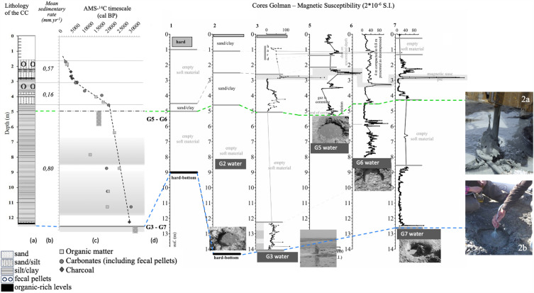
Large salt lakes are long-term witnesses to climatic conditions and land use in their basins. The majority are experiencing a drastic drop in water levels due to climate change and human impact. Endoreic Lake Urmia (NW Iran), the sixth largest salt lake worldwide, is a striking example of this decline. Quantification of the relative contributions of natural variability and human impact on the lake's water supply is therefore essential. Here we present isotopic and radiocarbon analyses of surface and groundwater from the Shahr Chay River catchment, entering Lake Urmia on its western shore, and radiocarbon dating of a sedimentary core. Lake Urmia behaves like a large saltwater wedge almost entirely fed by the river and shallow groundwater. This leads to trapping of residual brines and formation of CH4 and secondary CO2 greenhouse gases, impacting sediment geochemical records and corresponding time scales for paleoenvironmental reconstructions. We conclude that (1) salt lakes functioning like a saline wedge, allowing organic matter oxidation, could contribute to increasing methane sources or reducing carbon sinks globally, and (2) endoreic basins worldwide need to be monitored before aridification-related salinization leads to the establishment of a saline wedge precluding any possibility of return to an equilibrium state.
© 2023. The Author(s).
Conflict of interest statement
The authors declare no competing interests.
Figures


References
-
- Wurtsbaugh WA, et al. Decline of the world’s saline lakes. Nature Geosciences. 2017;10:816–821. doi: 10.1038/ngeo3052. - DOI
-
- Jones BF, et al. Geochemical evolution of great Salt Lake, Utah, USA. Aquat. Geochem. 2009;15:95–121. doi: 10.1007/s10498-008-9047-y. - DOI
-
- Vaheddoost B, Aksoy H. Interaction of groundwater with Lake Urmia in Iran. Hydrol. Process. 2018;32:3283–3295. doi: 10.1002/hyp.13263. - DOI
Grants and funding
LinkOut - more resources
Full Text Sources
