

Using integrated GIS and hydrological analysis for sizing culverts of multiple channel crossings at the flooded section of the Daboya-Mankarigu Road (IR10) in Ghana
- PMID: 38058439
- PMCID: PMC10696177
- DOI: 10.1016/j.heliyon.2023.e22863
Using integrated GIS and hydrological analysis for sizing culverts of multiple channel crossings at the flooded section of the Daboya-Mankarigu Road (IR10) in Ghana
Abstract
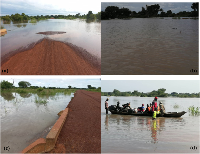
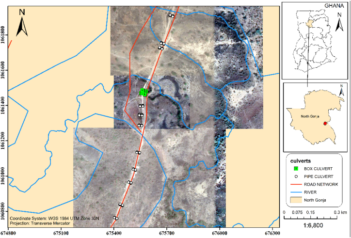
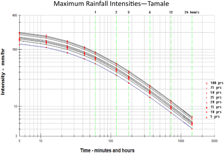
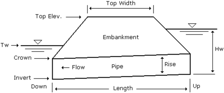
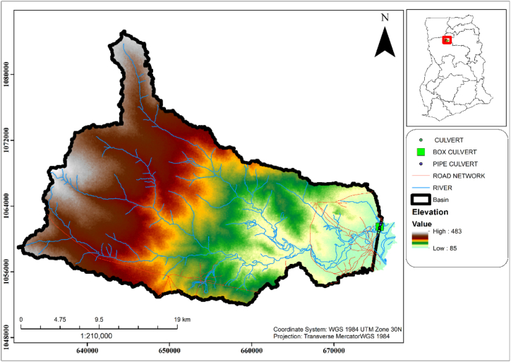
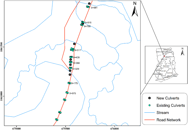
A culvert is an important structure in Road construction to allow the conveyance of Channels crossing the road. Culverts are sized for a road to accommodate the volume of water crossing the road network to avoid flooding. Ghana Highways has a standard manual for culvert sizing at channel crossing. This manual serves as a guide for the proper sizing of culverts, however, lots of culverts have been found to have failed. Among the reasons for the failure of culverts could be under-sizing, urbanization, climate change, lack of maintenance, etc. The Daboya-Mankarigu Road is situated in the Savanah Region of Ghana in the North Gonja District. The section of the road from Chainage 9 + 075 to 10 + 200 has been experiencing flooding from 2020 to 2021 with a flood depth of 3.315 m in 2020 and 2.00 m in 2021. This study seeks to use integrated GIS and hydrological-based methods to propose new culverts to supplement the existing culverts to control flooding at section (9 + 075 to 10 + 200) of Daboya-Mankarigu Road (IR10). Geographic Information system (GIS) model (SWAT), Hydrological and hydraulic models were used to determine the peak flow at the catchment to Propose new culverts to supplement the existing culverts. Using a design period of 25 years for culverts, the modified rational method was used to determine the Peak flow of the catchment. A 25-year peak flow of 367.155 m3/s was determined and used for hydraulic analysis of the existing culverts. From the study, the existing culvert structures at the section had a hydraulic capacity of 78.732 m3/s which could not accommodate the remaining flow of 288.423 m3/s in the catchment. An observation was made that the changes in the rainfall can cause a change in rainfall intensity. An increase in built-up areas in the catchment can also increase the runoff coefficient which can result in higher peak flow in the catchment. Climate change, change in slope, and Land use in the catchment were also determined to have a huge influence on the adequacy of culverts since the peak flow is dependent on these parameters in the catchment as the years go by. A 4No. 4 m × 4 m box culvert, 3No. 3.5 m × 3.5 m box culvert, and 13 No. 1200 mm pipe culverts with 2 each at different chainages were proposed at suitable locations to supplement the existing culverts using the HDS-5 equations in AutoCAD Civil 3D. A recommendation is made to consider the installation of these new culverts at the flood section to control flooding and avoid overtopping of water on the IR10 road section (Daboya-Mankarigu) in the north Gonja District.
Keywords: Box culvert; GIS; Hydrological model; Modified rational method; Peak flow; Pipe culvert; SWAT.
© 2023 The Authors.
Conflict of interest statement
The authors declare that they have no known competing financial interests or personal relationships that could have appeared to influence the work reported in this paper.
Figures

References
-
- Clifford A., Frimpong Boamah E. The three-dimensional causes of flooding in Accra, Ghana. Int. J. Urban Sustain. Dev. 2015;7(1):109–129.
-
- Kanga M.S., Koob J.H., Chunc J.A., Herd Y.G., Parka S.W., Yooe K. Biosystems Eng. 2009;104:425.
-
- Norman J.M., Houghtalen R.J., Johnson W.J. second ed. 2001. Hydraulic Design of Highway Culverts.
-
- Muste M., Ho H.C., Mehl D. The Iowa Highway Research Board; 2010. Insights into the Origin and Characteristics of the Sedimentation Process at Multi-Barrel Culverts in Iowa in: Technical Report IHRB Project TR-596.
-
- Kang M.S., Koo J.H., Chun J.A., Her Y.G., Park S.W., Yoo K. Design of drainage culverts considering critical storm duration. Biosyst. Eng. 2009;104(3):425–434. doi: 10.1016/j.biosystemseng.2009.07.004. - DOI
LinkOut - more resources
Full Text Sources
