

Remote sensing evidence for population growth of isolated indigenous societies in Amazonia
- PMID: 38105308
- PMCID: PMC10725865
- DOI: 10.1038/s41598-023-50127-y
Remote sensing evidence for population growth of isolated indigenous societies in Amazonia
Abstract
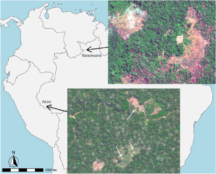
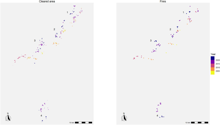
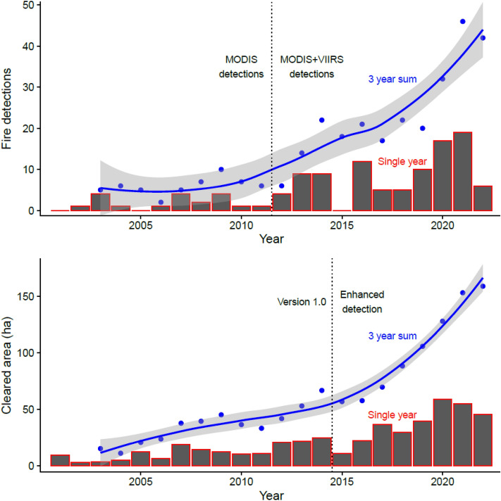
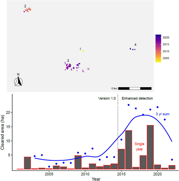
Isolated indigenous societies who actively avoid sustained peaceful contact with the outside world are critically endangered. Last year, "Tanaru", the lone surviving man of his tribe for at least 35 years, died in Southwest Amazonia, marking the latest cultural extinction event in a long history of massacres, enslavement, and epidemics. Yet in the upper reaches of the Amazon Basin, dozens of resilient isolated tribes still manage to survive. Remote sensing is a reliable method of monitoring the population dynamics of uncontacted populations by quantifying the area cleared for gardens and villages, along with the fire detections associated with the burning of those clearings. Remote sensing also provides a method to document the number of residential structures and village fissioning. Only with these longitudinal assessments can we better evaluate the current no-contact policies by the United Nations and governments, along with the prospects for the long-term survival of isolated tribes. While the world's largest isolated indigenous metapopulation, Pano speakers in Acre, Brazil, appears to be thriving, other smaller isolated populations disconnected from metapopulations continue to be extremely vulnerable to external threats. Our applied anthropological conservation approach is to provide analyses of publicly available remote sensing datasets to help inform policies that enhance the survival and well-being of isolated cultural groups.
© 2023. The Author(s).
Conflict of interest statement
The authors declare no competing interests.
Figures
Similar articles
-
Remote sensing and conservation of isolated indigenous villages in Amazonia.R Soc Open Sci. 2014 Nov 5;1(3):140246. doi: 10.1098/rsos.140246. eCollection 2014 Nov. R Soc Open Sci. 2014. PMID: 26064561 Free PMC article.
-
Machine learning with remote sensing data to locate uncontacted indigenous villages in Amazonia.PeerJ Comput Sci. 2019 Jan 7;5:e170. doi: 10.7717/peerj-cs.170. eCollection 2019. PeerJ Comput Sci. 2019. PMID: 33816823 Free PMC article.
-
Are Isolated Indigenous Populations Headed toward Extinction?PLoS One. 2016 Mar 8;11(3):e0150987. doi: 10.1371/journal.pone.0150987. eCollection 2016. PLoS One. 2016. PMID: 26954672 Free PMC article.
-
Drought impacts on the Amazon forest: the remote sensing perspective.New Phytol. 2010 Aug;187(3):569-78. doi: 10.1111/j.1469-8137.2010.03310.x. Epub 2010 Jun 1. New Phytol. 2010. PMID: 20524994 Review.
-
The Minderoo-Monaco Commission on Plastics and Human Health.Ann Glob Health. 2023 Mar 21;89(1):23. doi: 10.5334/aogh.4056. eCollection 2023. Ann Glob Health. 2023. PMID: 36969097 Free PMC article. Review.
Cited by
-
DBRSNet: a dual-branch remote sensing image segmentation model based on feature interaction and multi-scale feature fusion.Sci Rep. 2025 Jul 30;15(1):27786. doi: 10.1038/s41598-025-13236-4. Sci Rep. 2025. PMID: 40739124 Free PMC article.
References
-
- Le Tourneau FM. The sustainability challenges of indigenous territories in Brazil’s Amazonia. Curr. Opin. Environ. Sustain. 2015;14:213–220. doi: 10.1016/j.cosust.2015.07.017. - DOI
-
- Ferrante L, Gomes M, Fearnside PM. Amazonian indigenous peoples are threatened by Brazil’s Highway BR-319. Land Use Policy. 2020;94:104548. doi: 10.1016/j.landusepol.2020.104548. - DOI
