

Using geographic rescue time contours, point-of-care strategies, and spatial care paths to prepare island communities for global warming, rising oceans, and weather disasters
- PMID: 38124128
- PMCID: PMC10731708
- DOI: 10.1186/s12942-023-00359-y
Using geographic rescue time contours, point-of-care strategies, and spatial care paths to prepare island communities for global warming, rising oceans, and weather disasters
Abstract
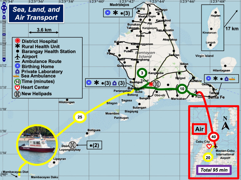
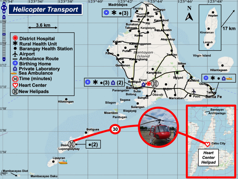
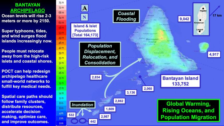
Objectives: To perform geographic contour analysis of sea and land ambulance rescue times in an archipelago subject to super typhoons; to design point-of-care testing strategies for medical emergencies and weather disasters made more intense by global warming and rising oceans; and to assess needs for prehospital testing on spatial care paths that accelerate decision making, increase efficiency, improve outcomes, and enhance standards of care in island nations.
Methods: We performed needs assessments, inspected healthcare facilities, and collected ambulance rescue times from professionals in the Bantayan Archipelago, Philippines. We mapped sea/land ambulance rescue routes and time contours. To reveal gaps, we statistically compared the fastest and slowest patient rescue times from islands/islets and barangays to the District Hospital on Bantayan Island. We developed spatial care paths (the fastest routes to care) for acute myocardial infarction, community care, and infectious diseases. We generated a compendium of prehospital diagnostic testing and integrated outcomes evidence, diagnostic needs, and public health goals to recommend point-of-care strategies that build geographic health resilience.
Results: We observed limited access to COVID-19 assays, absence of blood gas/pH testing for critical care support, and spatial gaps in land and airborne rescues that worsened during inclement weather and sea swells. Mean paired differences (slowest-fastest) in ambulance rescue times to the District Hospital for both islands and barangays were significant (P < 0.0001). Spatial care path analysis showed where point-of-care cardiac troponin testing should be implemented for expedited care of acute myocardial infarction. Geospatial strengths comprised distributed primary care that can be facilitated by point-of-care testing, logical interisland transfers for which decision making and triage could be accelerated with onboard diagnostics, and healthcare networks amenable to medical advances in prehospital testing that accelerate treatment.
Conclusions: Point-of-care testing should be positioned upstream close to homes and island populations that have prolonged rescue time contours. Geospatially optimized point-of-need diagnostics and distributed prehospital testing have high potential to improve outcomes. These improvements will potentially decrease disparities in mortality among archipelago versus urban dwellers, help improve island public health, and enhance resilience for increasingly adverse and frequent climate change weather disasters that impact vulnerable coastal areas. [350 words].
Keywords: Climate change; Geographic rescue time contours; Global warming; Island communities; Medical emergencies; Point-of-care strategies; Rising oceans; Spatial care paths; Spatial injustice; Weather disasters.
© 2023. The Author(s).
Conflict of interest statement
The authors confirm that there are no competing interests.
Figures


Similar articles
-
Community First Responders' role in the current and future rural health and care workforce: a mixed-methods study.Health Soc Care Deliv Res. 2024 Jul;12(18):1-101. doi: 10.3310/JYRT8674. Health Soc Care Deliv Res. 2024. PMID: 39054745
-
Rapid, point-of-care antigen tests for diagnosis of SARS-CoV-2 infection.Cochrane Database Syst Rev. 2022 Jul 22;7(7):CD013705. doi: 10.1002/14651858.CD013705.pub3. Cochrane Database Syst Rev. 2022. PMID: 35866452 Free PMC article.
-
Signs and symptoms to determine if a patient presenting in primary care or hospital outpatient settings has COVID-19.Cochrane Database Syst Rev. 2022 May 20;5(5):CD013665. doi: 10.1002/14651858.CD013665.pub3. Cochrane Database Syst Rev. 2022. PMID: 35593186 Free PMC article.
-
Comparison of Two Modern Survival Prediction Tools, SORG-MLA and METSSS, in Patients With Symptomatic Long-bone Metastases Who Underwent Local Treatment With Surgery Followed by Radiotherapy and With Radiotherapy Alone.Clin Orthop Relat Res. 2024 Dec 1;482(12):2193-2208. doi: 10.1097/CORR.0000000000003185. Epub 2024 Jul 23. Clin Orthop Relat Res. 2024. PMID: 39051924
-
Strategies of testing for syphilis during pregnancy.Cochrane Database Syst Rev. 2014 Oct 29;2014(10):CD010385. doi: 10.1002/14651858.CD010385.pub2. Cochrane Database Syst Rev. 2014. PMID: 25352226 Free PMC article.
Cited by
-
Statistical machine learning models for prediction of China's maritime emergency patients in dynamic: ARIMA model, SARIMA model, and dynamic Bayesian network model.Front Public Health. 2024 Jun 27;12:1401161. doi: 10.3389/fpubh.2024.1401161. eCollection 2024. Front Public Health. 2024. PMID: 39022407 Free PMC article.
-
Geospatial Point-of-Care Testing Strategies for COVID-19 Resilience in Resource-Poor Settings: Rural Cambodia Field Study.JMIR Public Health Surveill. 2024 Aug 27;10:e47416. doi: 10.2196/47416. JMIR Public Health Surveill. 2024. PMID: 39190459 Free PMC article.
-
Building evidences in Public Health Emergency Preparedness ("BePHEP" Project)-a systematic review.Int J Equity Health. 2025 Feb 11;24(1):41. doi: 10.1186/s12939-025-02382-w. Int J Equity Health. 2025. PMID: 39934889 Free PMC article.
References
-
- Slater T, Lawrence IR, Otosaka IN, Shepherd A, Gourmelen N, Jakob L, et al. The earth’s ice imbalance. Cryosphere. 2021;15:233–246. doi: 10.5194/tc-15-233-2021. - DOI
-
- McKei R. Earth has lost 28 trillion tonnes of ice in less than 30 years. The Guardian. 2020. https://www.theguardian.com/environment/2020/aug/23/earth-lost-28-trilli... Accessed 22 Nov 2023.
-
- Lindsey R. Climate change: Global sea level. NOAA Climate.gov. https://www.climate.gov/news-features/understanding-climate/climate-chan... Accessed 22 Nov 2023.
-
- United Nations. Climate and weather disasters surge five-fold over 50 years. 2021. https://news.un.org/en/story/2021/09/1098662 Accessed 22 Nov, 2023.
-
- Wright J. How many islands are the in the world? https://a-z-animals.com/blog/how-many-islands-are-in-the-world/ Accessed 22 Nov 2023.
Publication types
MeSH terms
LinkOut - more resources
Full Text Sources
Medical
