

SWECO25: a cross-thematic raster database for ecological research in Switzerland
- PMID: 38172116
- PMCID: PMC10764791
- DOI: 10.1038/s41597-023-02899-1
SWECO25: a cross-thematic raster database for ecological research in Switzerland
Abstract
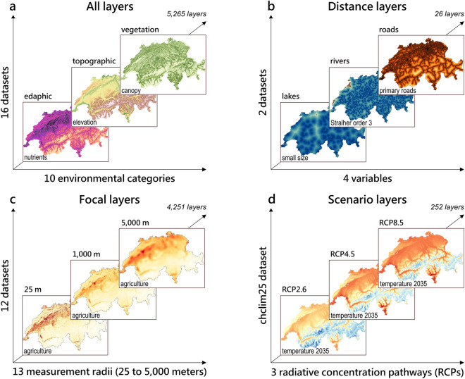
Standard and easily accessible cross-thematic spatial databases are key resources in ecological research. In Switzerland, as in many other countries, available data are scattered across computer servers of research institutions and are rarely provided in standard formats (e.g., different extents or projections systems, inconsistent naming conventions). Consequently, their joint use can require heavy data management and geomatic operations. Here, we introduce SWECO25, a Swiss-wide raster database at 25-meter resolution gathering 5,265 layers. The 10 environmental categories included in SWECO25 are: geologic, topographic, bioclimatic, hydrologic, edaphic, land use and cover, population, transportation, vegetation, and remote sensing. SWECO25 layers were standardized to a common grid sharing the same resolution, extent, and geographic coordinate system. SWECO25 includes the standardized source data and newly calculated layers, such as those obtained by computing focal or distance statistics. SWECO25 layers were validated by a data integrity check, and we verified that the standardization procedure had a negligible effect on the output values. SWECO25 is available on Zenodo and is intended to be updated and extended regularly.
© 2024. The Author(s).
Conflict of interest statement
The authors declare no competing interests.
Figures


References
-
- Dlamini SN, et al. Review of remotely sensed data products for disease mapping and epidemiology. Remote Sensing Applications: Society and Environment. 2019;14:108–118. doi: 10.1016/j.rsase.2019.02.005. - DOI
-
- Jamison A, Tuttle E, Jensen R, Bierly G, Gonser R. Spatial ecology, landscapes, and the geography of vector-borne disease: A multi-disciplinary review. Applied Geography. 2015;63:418–426. doi: 10.1016/j.apgeog.2015.08.001. - DOI
-
- Oliver, M. A. in Geostatistical Applications for Precision Agriculture (ed M.A. Oliver) 1-34 (Springer, 2010).
-
- Cambouris A, Zebarth B, Ziadi N, Perron I. Precision agriculture in potato production. Potato Research. 2014;57:249–262. doi: 10.1007/s11540-014-9266-0. - DOI
Publication types
LinkOut - more resources
Full Text Sources
