. 2023 Nov 30;5(1):100550.
doi: 10.1016/j.xinn.2023.100550. eCollection 2024 Jan 8.

Sahara's surface transformation forced an abrupt hydroclimate decline and Neolithic culture transition in northern China

Affiliations

Sahara's surface transformation forced an abrupt hydroclimate decline and Neolithic culture transition in northern China

Yandong Hou et al. Innovation (Camb). .

Abstract

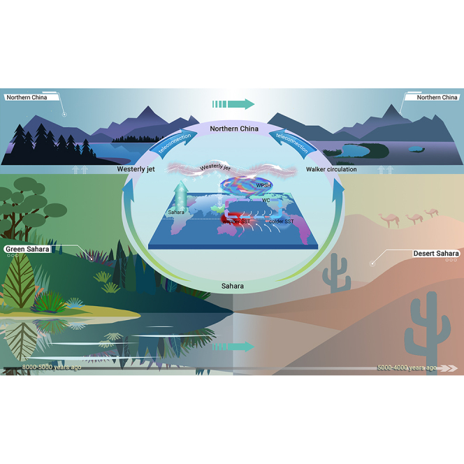
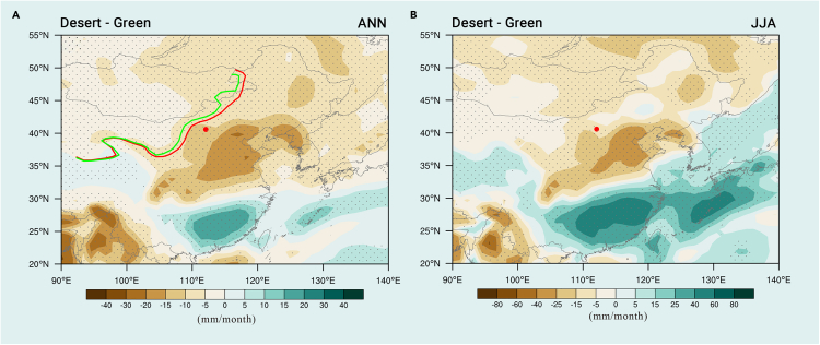
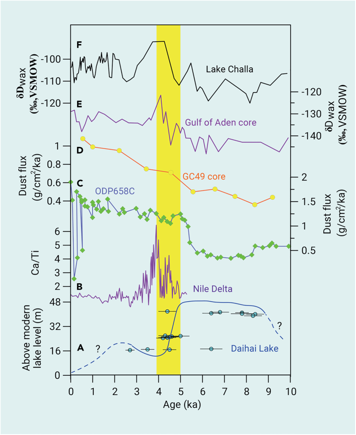
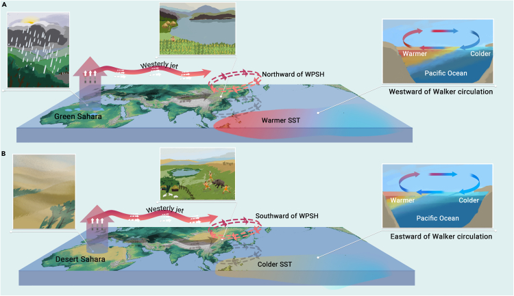
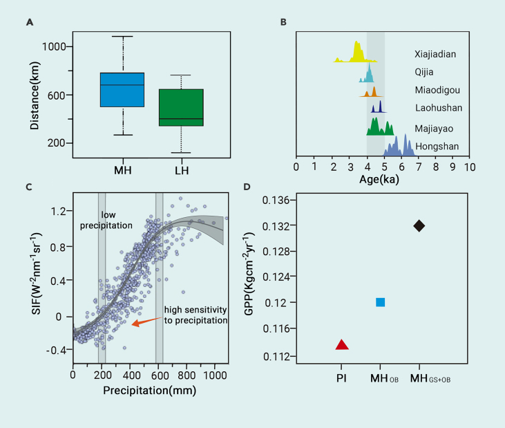
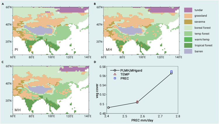
The remote forcing from land surface changes in the Sahara is hypothesized to play a pivotal role in modulating the intensity of the East Asian summer monsoon (EASM) through ocean-atmospheric teleconnections. This modulation has far-reaching consequences, particularly in facilitating societal shifts documented in northern China. Here, we present a well-dated lake-level record from the Daihai Lake Basin in northern China, providing quantitative assessments of Holocene monsoonal precipitation and the consequent migrations of the northern boundary of the EASM. Our reconstruction, informed by a water-and-energy balance model, indicates that annual precipitation reached ∼700 mm during 8-5 ka, followed by a rapid decline to ∼550 mm between 5 and 4 ka. This shift coherently aligns with a significant ∼300 km northwestward movement of the EASM northern boundary during the Middle Holocene (MH), in contrast to its current position. Our findings underscore that these changes cannot be entirely attributed to orbital forcing, as corroborated by simulation tests. Climate model simulations deployed in our study suggest that the presence of the Green Sahara during the MH significantly strengthened the EASM and led to a northward shift of the monsoon rainfall belt. Conversely, the Sahara's reversion to a desert landscape in the late Holocene was accompanied by a corresponding southward retraction of monsoon influence. These dramatic hydroclimate changes during ∼5-4 ka likely triggered or at least contributed to a shift in Neolithic cultures and societal transformation in northern China. With decreasing agricultural productivity, communities transitioned from millet farming to a mixed rainfed agriculture and animal husbandry system. Thus, our findings elucidate not only the variability of the EASM but also the profound implications of a remote forcing, such as surface transformations of the Sahara, on climatic changes and cultural evolution in northern China.


Conflict of interest statement

The authors declare no competing interests.

Figures

None
Graphical abstract
Figure 1
Figure 1
Locations of Daihai Lake, Hulun Lake, Daili Lake, and Baijian Lake and spatiotemporal distribution of archaeological sites in northern China Radiocarbon dates from Neolithic archeological sites are between 7 and 5 ka (A) and 5 and 4 ka (B).,,, The mean position of the EASM northern boundaries is in the PI (black solid line), 3 ka (red solid line), and 6 ka (blue solid line). A climatological northern boundary is defined as the May–September precipitation (300 mm precipitation isoline) in model stimulation.
Figure 2
Figure 2
Stratigraphy and chronology of sampling sections in Daihai Lake Basin
Figure 3
Figure 3
A widespread weakening of EASM in northern China at 5–4 ka (A) Lake-level changes at Daihai Lake (this study); (B and C) lake-level fluctuations of Daili Lake and Baijian Lake,; (D) δ18O records from Lianhua Cave; (E and F) quantitative precipitation reconstruction based on pollen data from lake cores from Hulun Lake and Daihai Lake., Yellow vertical color bar indicates the transition from wet to dry conditions between 5.0 and 4.0 ka.
Figure 4
Figure 4
Numerical simulation of precipitation in northern China Annual mean precipitation (A) and summer precipitation (B) anomalies (mm/month) under the effect of end of Saharan vegetation (MHDesert–MHGreen). The mean position of the EASM northern boundaries are Green Sahara (green solid line) and the end of Green Sahara (red solid line). The red dot denotes the location of Daihai Lake. ANN, annual.
Figure 5
Figure 5
Comparison of the lake-level changes of Daihai Lake with the end of the Green Sahara (A) Lake-level changes at Daihai Lake in present study; (B) Ca/Ti record of dust deposition in the Nile Delta; (C and D) terrigenous dust flux records from cores GC66 and ODP Site 658C,; (E and F) δDwax records from Lake Challa and marine core P178–15P. Yellow vertical color bar indicates the transition from a wet to a dry condition between 5.0 and 4.0 ka.
Figure 6
Figure 6
Schematic representation of the mechanisms behind the changes in EASM variability Changes in landscapes, westerly jet, WPSH, and Walker circulation between Green Sahara (A) and the end of Green Sahara (B).
Figure 7
Figure 7
The possible effect of climate change on the late Neolithic culture in northern China (A) The distances between culture relict sites and EASM northern boundary during the MH and LH. The bottom and top of the box represent the 25th and 75th percentiles (the lower and upper quartiles) of distance values, respectively. The band within the box indicates the median of the distances. (B) Density histogram of cultural 14C probability from prehistorical archeological sites; the 14C-dated sites belong to the Xiajiadian, Miaoizgou, Hongshan, Qijian, Laohushan, and Majiayao cultures. (C) Sensitivity analysis of SIF with respect to precipitation amount in northern China. (D) The stimulated GPP values in MHGS+OB, MHOB, and PI. OB, orbital.
Figure 8
Figure 8
Vegetation distributions and types in simulations Maps of dominant stimulated vegetation types during PI (A), MH (B), and MHgsrd (C), and foliar projective cover (D) over the East Asian.

Similar articles

References

    1. Yang X., Scuderi L.A., Wang X., et al. Groundwater sapping as the cause of irreversible desertification of Hunshandake Sandy Lands, Inner Mongolia, northern China. Proc. Natl. Acad. Sci. USA. 2015;112:702–706. - PMC - PubMed
    1. Yang B., Qin C., Bräuning A., et al. Long-term decrease in Asian monsoon rainfall and abrupt climate change events over the past 6,700 years. Proc. Natl. Acad. Sci. USA. 2021;118 - PMC - PubMed
    1. Griffiths M.L., Johnson K.R., Pausata F.S.R., et al. End of Green Sahara amplified mid- to late Holocene megadroughts in mainland Southeast Asia. Nat. Commun. 2020;11:4204. - PMC - PubMed
    1. Wang Z., Fu Z., Liu B., et al. Northward migration of the East Asian summer monsoon northern boundary during the twenty-first century. Sci. Rep. 2022;12 - PMC - PubMed
    1. Wang B., Liu J., Kim H.J., et al. Recent change of the global monsoon precipitation (1979–2008) Clim. Dyn. 2012;39:1123–1135.

LinkOut - more resources