

Seasonal prediction of the distribution of three major malaria vectors in China: Based on an ecological niche model
- PMID: 38236812
- PMCID: PMC10796015
- DOI: 10.1371/journal.pntd.0011884
Seasonal prediction of the distribution of three major malaria vectors in China: Based on an ecological niche model
Abstract
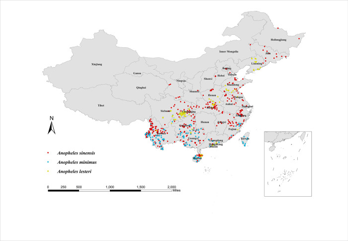
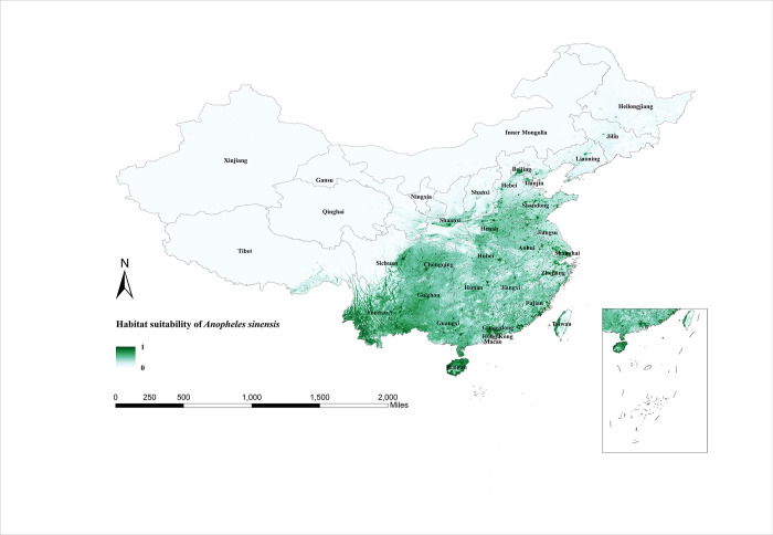
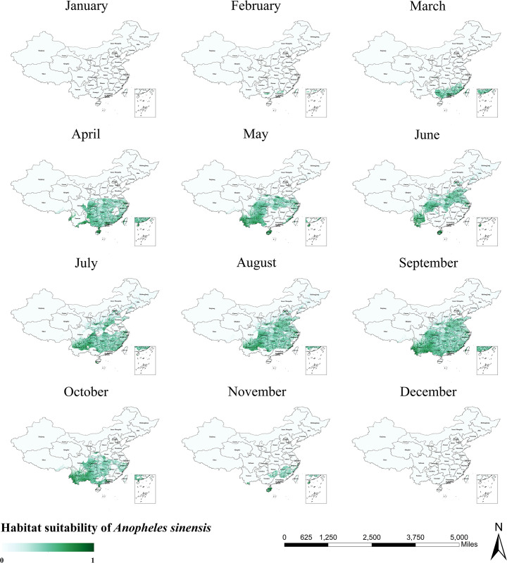
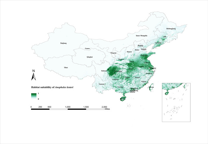
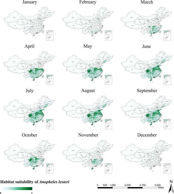
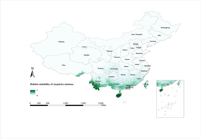
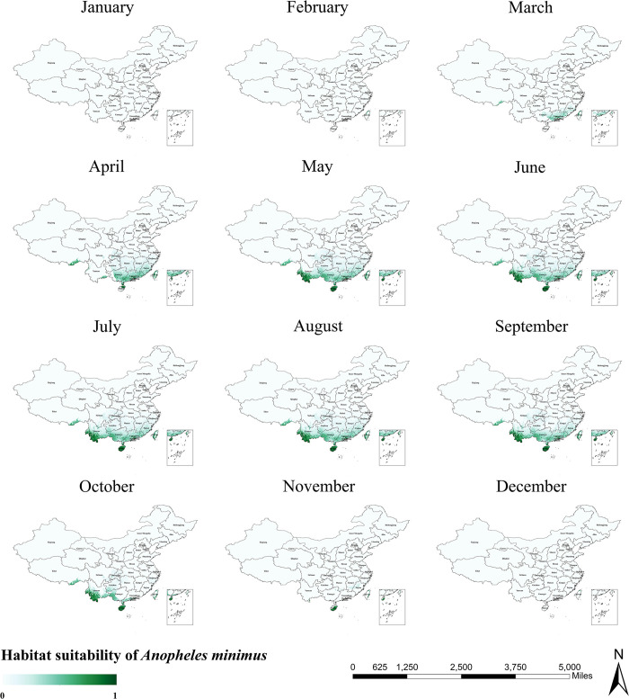
Against the backdrop of a global malaria epidemic that remains severe, China has eradicated indigenous malaria but still has to be alert to the risk of external importation. Understanding the distribution of vectors can provide an adequate and reliable basis for the development and implementation of vector control strategies. However, with the decline of malaria prevalence in recent years, the capacity of vector monitoring and identification has been greatly weakened. Here we have used new sampling records, climatic data, and topographic data to establish ecological niche models of the three main malaria vectors in China. The model results accurately identified the current habitat suitability areas for the three species of Anopheles and revealed that in addition to precipitation and temperature as important variables affecting the distribution of Anopheles mosquitoes, topographic variables also influenced the distribution of Anopheles mosquitoes. Anopheles sinensis is the most widespread malaria vector in China, with a wide region from the northeast (Heilongjiang Province) to the southwest (Yunnan Province) suitable for its survival. Suitable habitat areas for Anopheles lesteri are concentrated in the central, eastern, and southern regions of China. The suitable habitat areas of Anopheles minimus are the smallest and are only distributed in the border provinces of southern China. On this basis, we further assessed the seasonal variation in habitat suitability areas for these three major malaria vectors in China. The results of this study provide new and more detailed evidence for vector monitoring. In this new era of imported malaria prevention in China, regular reassessment of the risk of vector transmission is recommended.
Copyright: © 2024 An et al. This is an open access article distributed under the terms of the Creative Commons Attribution License, which permits unrestricted use, distribution, and reproduction in any medium, provided the original author and source are credited.
Conflict of interest statement
The authors declare that there is no conflict of interest.
Figures
Similar articles
-
Habitat suitability and ecological niche profile of major malaria vectors in Cameroon.Malar J. 2009 Dec 23;8:307. doi: 10.1186/1475-2875-8-307. Malar J. 2009. PMID: 20028559 Free PMC article.
-
Receptivity to malaria in the China-Myanmar border in Yingjiang County, Yunnan Province, China.Malar J. 2017 Nov 21;16(1):478. doi: 10.1186/s12936-017-2126-z. Malar J. 2017. PMID: 29162093 Free PMC article.
-
Vector Biology and Integrated Management of Malaria Vectors in China.Annu Rev Entomol. 2024 Jan 25;69:333-354. doi: 10.1146/annurev-ento-021323-085255. Annu Rev Entomol. 2024. PMID: 38270986 Review.
-
[Current malaria situation in the Republic of Kazakhstan].Med Parazitol (Mosk). 2001 Jan-Mar;(1):24-33. Med Parazitol (Mosk). 2001. PMID: 11548308 Russian.
-
[Strategies and studies of malaria vector control in Jiangsu Province].Zhongguo Xue Xi Chong Bing Fang Zhi Za Zhi. 2020 Oct 26;32(5):459-463. doi: 10.16250/j.32.1374.2020174. Zhongguo Xue Xi Chong Bing Fang Zhi Za Zhi. 2020. PMID: 33185055 Review. Chinese.
Cited by
-
Profile and Determinants for Complications of Imported Malaria in 5 Chinese Provinces From 2014 to 2021: Retrospective Analysis.JMIR Public Health Surveill. 2024 Aug 30;10:e52089. doi: 10.2196/52089. JMIR Public Health Surveill. 2024. PMID: 39212596 Free PMC article.
References
-
- WHO. World malaria report 2022: World Health Organization; 2022.
MeSH terms
LinkOut - more resources
Full Text Sources
Medical
