. 2024 Feb 6;14(1):3058.
doi: 10.1038/s41598-024-52733-w.

Air pollution seasons in urban moderate climate areas through big data analytics

Affiliations

Air pollution seasons in urban moderate climate areas through big data analytics

Mateusz Zareba et al. Sci Rep. .

Abstract

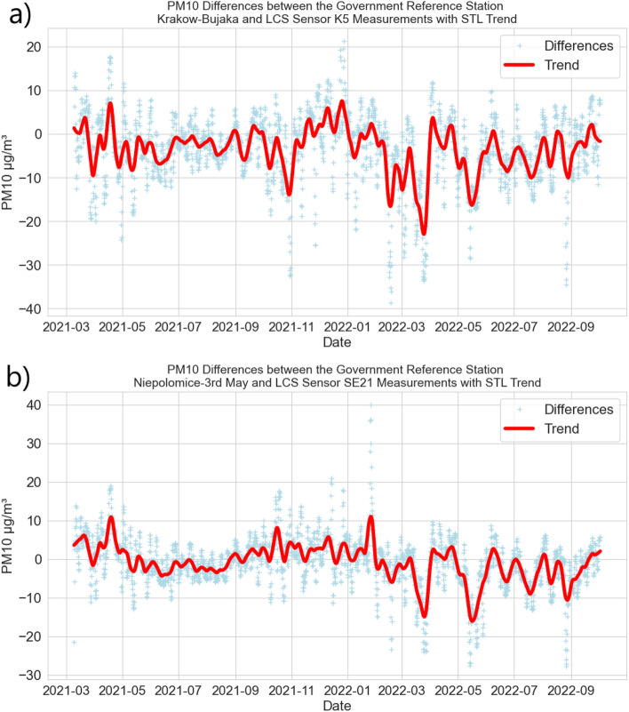
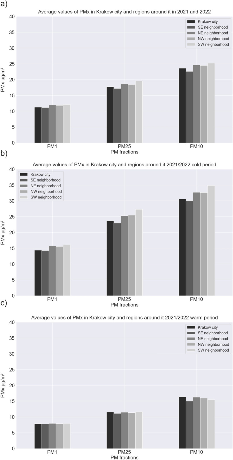
High particulate matter (PM) concentrations have a negative impact on the overall quality of life and health. The annual trends of PM can vary greatly depending on factors such as a country's energy mix, development level, and climatic zone. In this study, we aimed to understand the annual cycle of PM concentrations in a moderate climate zone using a dense grid of low-cost sensors located in central Europe (Krakow). Over one million unique records of PM, temperature, humidity, pressure and wind speed observations were analyzed to gain a detailed, high-resolution understanding of yearly fluctuations. The comprehensive big-data workflow was presented with the statistical analysis of the meteorological factors. A big data-driven approach revealed the existence of two main PM seasons (warm and cold) in Europe's moderate climate zone, which do not correspond directly with the traditional four main seasons (Autumn, Winter, Spring, and Summer) with two side periods (early spring and early winter). Our findings also highlighted the importance of high-resolution time and space data for sustainable spatial planning. The observations allowed for distinguishing whether the source of air pollution is related to coal burning for heating in cold period or to agricultural lands burning during the warm period.


Conflict of interest statement

The authors declare no competing interests.

Figures

Figure 1
Figure 1
Digital terrain model of Krakow (grey lines—city districts borders) and its surrounding with airly sensor locations (ID in black) together with the rivers (blue lines). Data sources: Digital terrain—European Union, Copernicus Land Monitoring Service 2022, European Environment Agency (EEA); Europe Map—OpenStreetMap.
Figure 2
Figure 2
Big data workflow.
Figure 3
Figure 3
Cross-plot of PM10 signals from the Government Reference Station (GRS) and near LCS sensor measurements (light blue) with regression line (orange): (a) GRS—urban area Krakow–Bujaka and LCS K5; (b) GRS—forest area Niepolomice-3rd May and LCS SE21.
Figure 4
Figure 4
PM10 differences between the Government Reference Station (GRS) and near LCS sensor measurements (light blue) with 7-day STL trend (red): (a) GRS—urban area Krakow–Bujaka and LCS K5; (b) GRS—forest area Niepolomice-3rd May and LCS SE21.
Figure 5
Figure 5
Monthly averages of PM10 (black) and meteorological factors: pressure (green); temperature (red); humidity (yellow). Values calculated based on all available observations.
Figure 6
Figure 6
Monthly median of PM10 (black) and meteorological factors: pressure (green); temperature (red); humidity (yellow). Values calculated based on the all available observations.
Figure 7
Figure 7
Box plots of average wind speed in investigated region.
Figure 8
Figure 8
Relation between meteorological factors (temperature, humidity, and pressure) and PM10 calculated for all observations in the following periods: astronomical summer (salmon), autumn (brown), winter (light blue), spring (green); and in pollution seasons: warm (red), cold (dark blue).
Figure 9
Figure 9
Kernel density estimate plots of PM10 and temperature in cold season for (a) Krakow city; (b) southeastern region; (c) northeastern region; (d) northwestern region; (e) southwestern region. Green rectangle represents the allowed air pollution level, red one represents exceeded concentrations.
Figure 10
Figure 10
PM1, PM2.5, and PM10 concentrations (March 2021–February 2022) in: (a) Krakow city; (b) southeastern region; (c) northeastern region; (d) northwestern region; (e) southwestern region.
Figure 11
Figure 11
The average values of PM1, PM2.5, and PM10 in Krakow city and regions around the city for (a) 1-year period; (b) cold period; (c) warm period.
Figure 12
Figure 12
The maximum values of PM1, PM2.5, and PM10 in Krakow city and regions around the city for (a) 1-year period; (b) cold period; (c) warm period.
Figure 13
Figure 13
PM10 1-month average concentration maps for year cycle pattern analysis.
Figure 14
Figure 14
PM10 1-month maximum concentration maps for year cycle pattern analysis.
Figure 15
Figure 15
Air quality index clusters map in Krakow during the 1-year period.

References

    1. Thurston G, et al. A joint era/ats policy statement: What constitutes an adverse health effect of air pollution? an analytical framework. Eur. Respir. J. 2017;49:1600419. doi: 10.1183/13993003.00419-2016. - DOI - PMC - PubMed
    1. Aydin, N. Europe has largest aging population in world (2022). Accessed 13 Jan 2023.
    1. Doiron D, Bourbeau J, de Hoogh K, Hansell A. Ambient air pollution exposure and chronic bronchitis in the lifelines cohort. Thorax. 2021;76:772–779. doi: 10.1136/thoraxjnl-2020-216142. - DOI - PMC - PubMed
    1. Kuzma L, et al. Exposure to air pollution and its effect on ischemic strokes (ep-particles study) Sci. Rep. 2022 doi: 10.1038/s41598-022-21585-7. - DOI - PMC - PubMed
    1. Raaschou-Nielsen O, et al. Air pollution and lung cancer incidence in 17 European cohorts: Prospective analyses from the European study of cohorts for air pollution effects (escape) Lancet Oncol. 2013;14:813–822. doi: 10.1016/S1470-2045(13)70279-1. - DOI - PubMed