Review
. 2024 Apr;382(2269):20230065.
doi: 10.1098/rsta.2023.0065. Epub 2024 Feb 12.

Geodiversity in the Amazon drainage basin

Affiliations
Review

Geodiversity in the Amazon drainage basin

Cécile M E Alsbach et al. Philos Trans A Math Phys Eng Sci. 2024 Apr.

Abstract

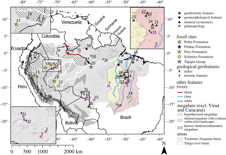
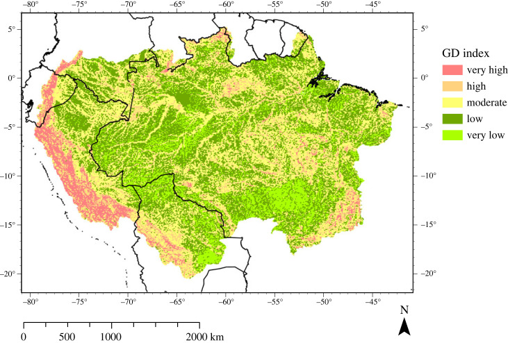
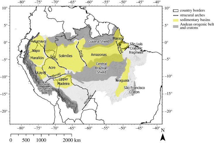
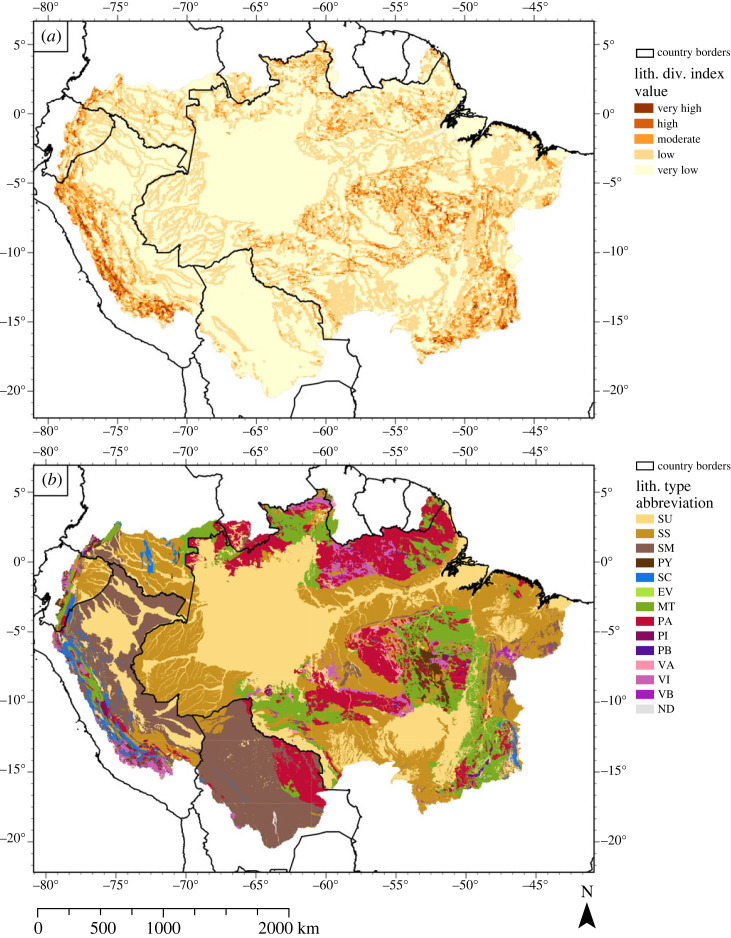
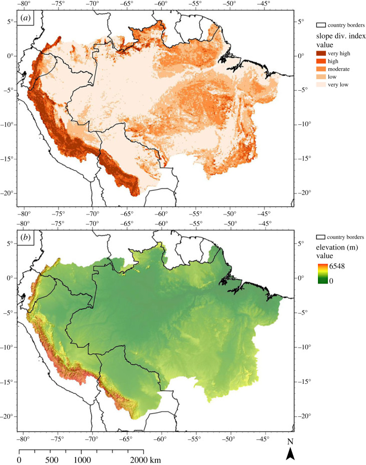
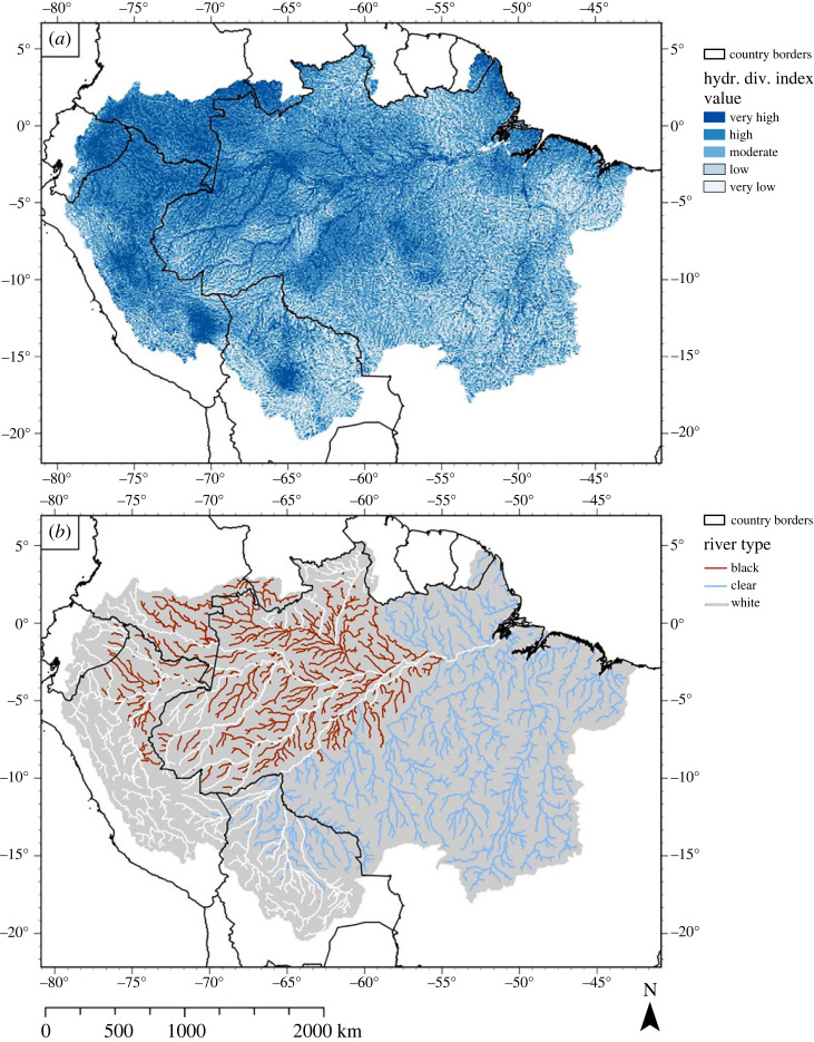
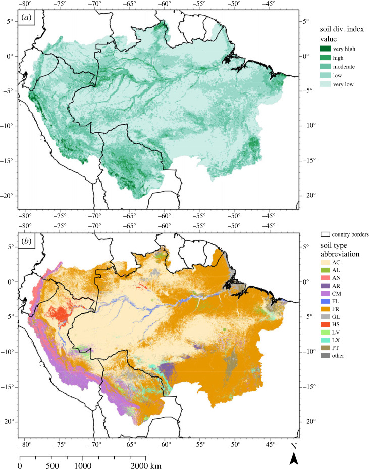
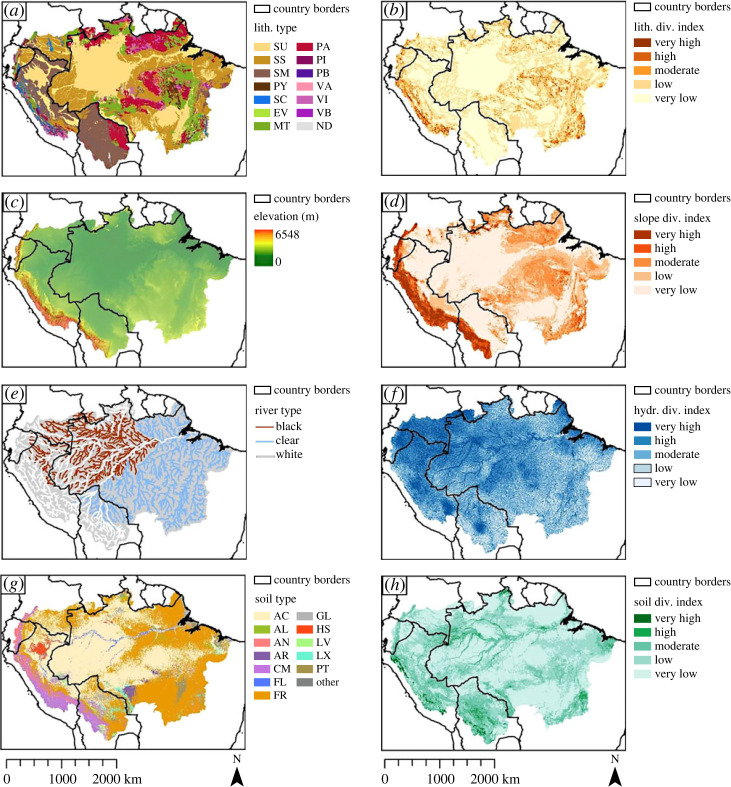
The Amazon is the largest drainage basin on Earth and contains a wide variety of abiotic landscape features. In spite of this, the geodiversity in this basin has not yet been objectively evaluated. We address this knowledge gap by combining a meta-analysis of an existing global geodiversity map and its components with a systematic literature review, to identify the key characteristics of geodiversity in the Amazon drainage basin (ADB). We also evaluate how these global geodiversity component maps, that are based on the geology, geomorphology, soils and hydrology, could be refined to better reflect geodiversity in the basin. Our review shows that geology-through lithological diversity and geological structures-and hydrology-through hydrological processes that influence geomorphology and soil diversity-are the main determinants of geodiversity. Based on these features, the ADB can be subdivided into three principal regions: (i) the Andean orogenic belt and western Amazon, (ii) the cratons and eastern Amazon, and (iii) the Solimões-Amazon river system. Additional methods to map geomorphological and hydrological diversity have been identified. Future research should focus on investigating the relationship between the geodiversity components and assess their relationship with biodiversity. Such knowledge can enhance conservation plans for the ADB. This article is part of the Theo Murphy meeting issue 'Geodiversity for science and society'.

Keywords: Amazonia; geodiversity; geology; geomorphology; hydrology; soils.


Conflict of interest statement

A.C.S. has a joint publication with the guest editors J.J.B., R.F. and F.S. C.H. is co-author in a paper led by guest editor F.S.

Figures

Figure 1.
Figure 1.
Map showing the extent of the ADB, sensu lato, according to Albert et al. [21], as well as areas and locations mentioned in the text and country names. See table 2 for the locations’ names and corresponding articles. Tocantins-Araguaia and Xingu river basins were retrieved from Venticinque et al. [22]. Locations of the megafans, excluding Viruá and Caracarai megafans, were retrieved from Wilkinson et al. [23] and Latrubesse et al. [24]. (Online version in colour.)
Figure 2.
Figure 2.
Distribution of geodiversity in the ADB. This map is based on calculating and adding separate indices of geology, topography, soil types and hydrology (table 1), and presenting geodiversity index scores in five classes (very low to very high) using a Jenks natural breaks classification [41]. (Online version in colour.)
Figure 3.
Figure 3.
Map showing the major sedimentary basins, AOB, cratons and structural arches in the ADB. Map created after Albert et al. [48], used with permission from the first author. Location of the São Luís cratonic fragment retrieved from Klein et al. [49]. (Online version in colour.)
Figure 4.
Figure 4.
(a) Distribution of geological diversity in the ADB. Each 10 km × 10 km raster cell was awarded a score, based on the lithological variety in that cell. Index classes (very low to very high) were created using a Jenks natural breaks classification (see Polman et al. [40] for detailed information). (b) Map showing the most likely lithology according to Hartmann & Moosdorf [42]. SU, unconsolidated sediments; SS, siliclastic sedimentary rock; SM, mixed sedimentary rocks; PY, pyroclastics; SC, carbon sedimentary rock; EV, evaporite; MT, metamorphic rock; PA, acid plutonic rock; PI, intermediate plutonic rock; PB, basic plutonic rock; VA, acid volcanic rock; VI, intermediate volcanic rock; VB, basic volcanic rock; ND, no data. (Online version in colour.)
Figure 5.
Figure 5.
(a) Distribution of geomorphological diversity in the ADB. Each 10 km × 10 km raster cell was awarded a score, based on the slope diversity (calculated from the standard deviation and range of the slope) in that cell. Index classes (very low to very high) were created using a Jenks natural breaks classification (see Polman et al. [40] for detailed information). (b) Digital elevation model (DEM) of the ADB, overlaid with a hillshade. Based on data from Yamazaki et al. [43]. (Online version in colour.)
Figure 6.
Figure 6.
(a) Distribution of hydrological diversity in the ADB. Each 10 km × 10 km raster cell was awarded a score based on the hydrological variety (based on river length and lake area metrics) in that cell. Index classes (very low to very high) were created using a Jenks natural breaks classification (see Polman et al. [40] for detailed information). (b) Map showing an alternative approach to hydrological diversity, i.e. hydrogeochemical diversity, using a classification system commonly used in the Amazon drainage basin devised by Sioli [145]. Data retrieved from Venticinque et al. [22]. (Online version in colour.)
Figure 7.
Figure 7.
(a) Distribution of soil diversity in the ADB. Each 10 km × 10 km raster cell was awarded a score, based on the soil variety in that cell. Index classes (very low to very high) were created using a Jenks natural breaks classification (see Polman et al. [40] for detailed information). (b) Map showing the most likely soil type across the ADB. It serves as the source data for the soil diversity map. The data are retrieved from Hengl et al. [44]. AC, Acrisol; AL, Alisol; AN, Andosol; AR, Arenosol; CM, Cambisol; FR, Ferralsol; GL, Gleysol; HS, Histosol; LV, Luvisol; LX, Lixisol; PT, Plithisol; other, other soil types that were distributed too sparsely to be viewable. (Online version in colour.)
Figure 8.
Figure 8.
Overview of all geodiversity components and their base map. (a) Lithological diversity index, (b) most likely lithology, (c) DEM of the ADB, (d) slope diversity index, (e) river types of the major rivers in the ADB, (f) hydrological diversity index, (g) most likely soil type and (h) soil diversity index. For data sources and legend abbreviations, see original figures. (Online version in colour.)

Similar articles

  • Global geodiversity components are not equally represented in UNESCO Global Geoparks.
    Polman EMN, Seijmonsbergen AC, Versteegh H, Kissling WD. Polman EMN, et al. Philos Trans A Math Phys Eng Sci. 2024 Apr;382(2269):20230054. doi: 10.1098/rsta.2023.0054. Epub 2024 Feb 12. Philos Trans A Math Phys Eng Sci. 2024. PMID: 38342215 Free PMC article.
  • Towards a taxonomy of geodiversity.
    Hjort J, Seijmonsbergen AC, Kemppinen J, Tukiainen H, Maliniemi T, Gordon JE, Alahuhta J, Gray M. Hjort J, et al. Philos Trans A Math Phys Eng Sci. 2024 Apr;382(2269):20230060. doi: 10.1098/rsta.2023.0060. Epub 2024 Feb 12. Philos Trans A Math Phys Eng Sci. 2024. PMID: 38342205 Free PMC article.
  • Geodiversity data for Europe.
    Toivanen M, Maliniemi T, Hjort J, Salminen H, Ala-Hulkko T, Kemppinen J, Karjalainen O, Poturalska A, Kiilunen P, Snåre H, Leppiniemi O, Makopoulou E, Alahuhta J, Tukiainen H. Toivanen M, et al. Philos Trans A Math Phys Eng Sci. 2024 Apr;382(2269):20230173. doi: 10.1098/rsta.2023.0173. Epub 2024 Feb 12. Philos Trans A Math Phys Eng Sci. 2024. PMID: 38342206 Free PMC article.
  • The status and future of essential geodiversity variables.
    Schrodt F, Vernham G, Bailey J, Field R, Gordon JE, Gray M, Hjort J, Hoorn C, Hunter ML Jr, Larwood J, Lausch A, Monge-Ganuzas M, Miller S, van Ree D, Seijmonsbergen AC, Zarnetske PL, Daniel Kissling W. Schrodt F, et al. Philos Trans A Math Phys Eng Sci. 2024 Apr;382(2269):20230052. doi: 10.1098/rsta.2023.0052. Epub 2024 Feb 12. Philos Trans A Math Phys Eng Sci. 2024. PMID: 38342208 Free PMC article. Review.
  • The dilemma of valuing geodiversity: geoconservation versus geotourism.
    Anougmar S, Meesters A, van Ree D, Compernolle T. Anougmar S, et al. Philos Trans A Math Phys Eng Sci. 2024 Apr;382(2269):20230049. doi: 10.1098/rsta.2023.0049. Epub 2024 Feb 12. Philos Trans A Math Phys Eng Sci. 2024. PMID: 38342217 Free PMC article. Review.

Cited by

References

    1. Gray M. 2008. Geodiversity: developing the paradigm. Proc. Geol. Assoc. 119, 287-298. (10.1016/S0016-7878(08)80307-0) - DOI
    1. Gray M. 2004. Geodiversity: valuing and conserving abiotic nature, pp. 1-9. Chichester, UK: John Wiley & Sons, Ltd.
    1. Serrano E, Ruiz-Flaño P. 2007. Geodiversity: a theoretical and applied concept. Geogr. Helv. 62, 140-147. (10.5194/gh-62-140-2007) - DOI
    1. Antonelli A et al. 2018. Geological and climatic influences on mountain biodiversity. Nat. Geosci. 11, 718-725. (10.1038/s41561-018-0236-z) - DOI
    1. Schrodt F et al. 2019. To advance sustainable stewardship, we must document not only biodiversity but geodiversity. Proc. Natl Acad. Sci. USA 116, 16 155-161 658. (10.1073/pnas.1911799116) - DOI - PMC - PubMed

LinkOut - more resources