Global geodiversity components are not equally represented in UNESCO Global Geoparks
- PMID: 38342215
- PMCID: PMC10859229
- DOI: 10.1098/rsta.2023.0054
Global geodiversity components are not equally represented in UNESCO Global Geoparks
Abstract
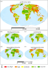
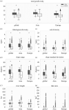
The aim of UNESCO Global Geoparks (UGGs) is to protect globally significant geoheritage and geodiversity, but quantitative evidence on the global representativeness of geodiversity components (i.e. geology, soils, geomorphology and hydrology) in these geoparks is in short supply. Here, we provide a first assessment by deriving a global map of geodiversity to test whether the presence of geodiversity components in UGGs is representative for the global availability and distribution of geodiversity. Using openly accessible global datasets and a newly developed workflow, we have calculated metrics for each geodiversity component and a global geodiversity index; we then quantified whether UGGs represent global geodiversity and then compared their components to a randomized spatial distribution of geoparks. Our results show that lithological and topographical diversity are more represented in UGGs than outside these sites, while soil type and hydrological diversity are not significantly different. Furthermore, individual soil types and lithological classes are under-represented and unevenly distributed in Asian and European UGGs. This is probably caused by the concentration of geoparks in Asian and European mountains. To better conserve geodiversity, we suggest an initiative to consider the protection and representation of all geodiversity components in their global context. This article is part of the Theo Murphy meeting issue 'Geodiversity for science and society'.
Keywords: UNESCO Global Geoparks; geoconservation; geodiversity mapping; global geodiversity; protected areas.
Conflict of interest statement
A.C.S. and W.D.K. have a joint publication with the guest editors J.J.B., R.F. and F.S.
All authors gave final approval for publication and agreed to be held accountable for the work performed therein.
Figures


Similar articles
-
Geodiversity in the Amazon drainage basin.Philos Trans A Math Phys Eng Sci. 2024 Apr;382(2269):20230065. doi: 10.1098/rsta.2023.0065. Epub 2024 Feb 12. Philos Trans A Math Phys Eng Sci. 2024. PMID: 38342214 Free PMC article. Review.
-
Geodiversity and geoheritage: Detecting scientific and geographic biases and gaps through a bibliometric study.Sci Total Environ. 2019 Apr 1;659:1032-1044. doi: 10.1016/j.scitotenv.2018.12.443. Epub 2018 Dec 29. Sci Total Environ. 2019. PMID: 31096319
-
A framework for quantifying geodiversity at the local scale: a case study from the Rokua UNESCO Global Geopark.Philos Trans A Math Phys Eng Sci. 2024 Apr;382(2269):20230059. doi: 10.1098/rsta.2023.0059. Epub 2024 Feb 12. Philos Trans A Math Phys Eng Sci. 2024. PMID: 38342220 Free PMC article.
-
Case studies associated with the 10 major geodiversity-related topics.Philos Trans A Math Phys Eng Sci. 2024 Apr;382(2269):20230055. doi: 10.1098/rsta.2023.0055. Epub 2024 Feb 12. Philos Trans A Math Phys Eng Sci. 2024. PMID: 38342216 Free PMC article. Review.
-
Quantitative measurement of geodiversity uniqueness: research implications and conservation applications.Philos Trans A Math Phys Eng Sci. 2024 Apr;382(2269):20230056. doi: 10.1098/rsta.2023.0056. Epub 2024 Feb 12. Philos Trans A Math Phys Eng Sci. 2024. PMID: 38342212
Cited by
-
Geodiversity in the Amazon drainage basin.Philos Trans A Math Phys Eng Sci. 2024 Apr;382(2269):20230065. doi: 10.1098/rsta.2023.0065. Epub 2024 Feb 12. Philos Trans A Math Phys Eng Sci. 2024. PMID: 38342214 Free PMC article. Review.
-
Geodiversity for science and society.Philos Trans A Math Phys Eng Sci. 2024 Apr;382(2269):20230062. doi: 10.1098/rsta.2023.0062. Epub 2024 Feb 12. Philos Trans A Math Phys Eng Sci. 2024. PMID: 38342210 Free PMC article. No abstract available.
References
-
- Chakraborty A, Gray M. 2020. A call for mainstreaming geodiversity in nature conservation research and praxis. J. Nat. Conserv. 56, 125862. (10.1016/j.jnc.2020.125862) - DOI
-
- Kiernan K. 2010. Human impacts on geodiversity and associated natural values of bedrock hills in the Mekong delta. Geoheritage 2, 101-122. (10.1007/s12371-010-0015-8) - DOI
-
- Fox N, Graham LJ, Eigenbrod F, Bullock JM, Parks KE. 2022. Geodiversity Supports Cultural Ecosystem Services: an Assessment Using Social Media. Geoheritage 14, 27. (10.1007/s12371-022-00665-0) - DOI
-
- Gray M. 2012. Valuing geodiversity in an ‘ecosystem services’ context. Scottish Geogr. J. 128, 177-194. (10.1080/14702541.2012.725858) - DOI
-
- Van Ree CCDF, Van Beukering PJH. 2016. Geosystem services: a concept in support of sustainable development of the subsurface. Ecosyst. Serv. 20, 30-36. (10.1016/j.ecoser.2016.06.004) - DOI
LinkOut - more resources
Full Text Sources

