

Terrestrial LiDAR point cloud dataset of cocoa trees grown in agroforestry systems in Cameroon
- PMID: 38348320
- PMCID: PMC10859249
- DOI: 10.1016/j.dib.2024.110108
Terrestrial LiDAR point cloud dataset of cocoa trees grown in agroforestry systems in Cameroon
Abstract
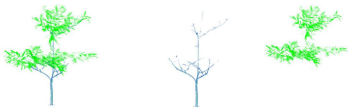
This paper presents a dataset aimed at characterizing cocoa trees cultivated within complex agroforestry systems managed by smallholder farmers in the Central region of Cameroon. The dataset highlights the architectural structure of the trees as well as the distribution of their leaves and wood using 3D point clouds obtained through the Leica ScanStation C10 terrestrial LiDAR. The data collection campaign was conducted in August 2019 in the district of Bokito (latitude 4°34' N and longitude 11°07' E), specifically within the village of Yorro located in a transition zone between forest and savannah. The dataset includes information on 55 cocoa trees, spread over five distinct architectural types. These trees were sampled from various age stands ranging from 5- to 70-year-old. For 29 of these trees, a leaf/wood segmentation of the point clouds was performed. For each of these trees, the dataset comprises the raw point cloud of the entire tree, as well as separate point clouds for the leaves and wood, each in two distinct sets of 3D points. The data provides the foundation for conducting numerous cocoa tree measurements based on their representation in point clouds, allowing for a more comprehensive understanding of their architecture, photosynthetic capacity, and distribution of above-ground biomass.
Keywords: Agroecological forestry; Biomass; Leaf/wood segmentation; LiDAR; Theobroma; Tree architecture.
© 2024 The Author(s).
Figures


References
-
- Jagoret P., Snoeck D., Bouambi E., Todem Ngnogue H., Nyassé S., Saj S. Rehabilitation practices that shape cocoa agroforestry systems in Central Cameroon: key management strategies for long-term exploitation. Agroforest. Syst. 2018;92(15):1185–1199. doi: 10.1007/s10457-016-0055-4. - DOI
-
- Wang D., Momo Takoudjou S., Casella E. LeWoS: a universal leaf-wood classification method to facilitate the 3D modelling of large tropical trees using terrestrial LiDAR. Methods Ecol. Evol. 2019;11(13):376–389. doi: 10.1111/2041-210X.13342. - DOI
-
- Martin-Ducup O., Ploton P., Barbier N., Momo Takoudjou S., Mofack G., II, Kamdem N.G., Fourcaud T., Sonké B., Couteron P., R. Pélissier Terrestrial laser scanning reveals convergence of tree architecture with increasingly dominant crown canopy position. Funct. Ecol. 2020;34:2442–2452. doi: 10.1111/1365-2435.13678. - DOI
-
- Raumonen P., Casella E., Murphy S., Åkerblom M., Kaasalainen M. ISPRS Annals of the Photogrammetry, Remote Sensing and Spatial Information Sciences, Vols. 1. 2015. Massive-scale tree modelling from TLS data; pp. 189–196. - DOI
-
- Momo Takoudjou S., Ploton P., Sonké B., Hackenberg J., Griffon S., de Coligny F., Kamdem N.G., Libalah M., Mofack G., le Moguédec G., Pélissier R., Barbier N. Using terrestrial laser scanning data to estimate large tropical trees biomass and calibrate allometric models: a comparison with traditional destructive approach. Methods Ecol. Evol. 2018;9(14):905–916. doi: 10.1111/2041-210X.12933. - DOI
LinkOut - more resources
Full Text Sources
