

Multispectral Light Detection and Ranging Technology and Applications: A Review
- PMID: 38475205
- PMCID: PMC10934921
- DOI: 10.3390/s24051669
Multispectral Light Detection and Ranging Technology and Applications: A Review
Abstract
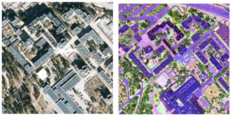
Light Detection and Ranging (LiDAR) is a well-established active technology for the direct acquisition of 3D data. In recent years, the geometric information collected by LiDAR sensors has been widely combined with optical images to provide supplementary spectral information to achieve more precise results in diverse remote sensing applications. The emergence of active Multispectral LiDAR (MSL) systems, which operate on different wavelengths, has recently been revolutionizing the simultaneous acquisition of height and intensity information. So far, MSL technology has been successfully applied for fine-scale mapping in various domains. However, a comprehensive review of this modern technology is currently lacking. Hence, this study presents an exhaustive overview of the current state-of-the-art in MSL systems by reviewing the latest technologies for MSL data acquisition. Moreover, the paper reports an in-depth analysis of the diverse applications of MSL, spanning across fields of "ecology and forestry", "objects and Land Use Land Cover (LULC) classification", "change detection", "bathymetry", "topographic mapping", "archaeology and geology", and "navigation". Our systematic review uncovers the potentials, opportunities, and challenges of the recently emerged MSL systems, which integrate spatial-spectral data and unlock the capability for precise multi-dimensional (nD) mapping using only a single-data source.
Keywords: hyperspectral LiDAR; intensity; multispectral laser scanning; point clouds; sensors.
Conflict of interest statement
The authors declare no conflicts of interest.
Figures


References
-
- Shan J., Toth C.K. Topographic Laser Ranging and Scanning: Principles and Processing. CRC Press; Boca Raton, FL, USA: 2018.
-
- Riveiro B., Lindenbergh R. Laser Scanning: An Emerging Technology in Structural Engineering. Volume 14 CRC Press; Boca Raton, FL, USA: 2019.
-
- Dalponte M., Bruzzone L., Gianelle D. Fusion of hyperspectral and LIDAR remote sensing data for classification of complex forest areas. IEEE Trans. Geosci. Remote Sens. 2008;46:1416–1427. doi: 10.1109/TGRS.2008.916480. - DOI
-
- Buckley S.J., Kurz T.H., Howell J.A., Schneider D. Terrestrial lidar and hyperspectral data fusion products for geological outcrop analysis. Comput. Geosci. 2013;54:249–258. doi: 10.1016/j.cageo.2013.01.018. - DOI
-
- Kuras A., Brell M., Rizzi J., Burud I. Hyperspectral and lidar data applied to urban land cover machine learning and neural-network-based classification: A review. Remote Sens. 2021;13:3393. doi: 10.3390/rs13173393. - DOI
Publication types
LinkOut - more resources
Full Text Sources
