. 2024 Mar 15;14(1):6246.
doi: 10.1038/s41598-024-56338-1.

Mapping the habitat refugia of Isidella elongata under climate change and trawling impacts to preserve Vulnerable Marine Ecosystems in the Mediterranean

Affiliations

Mapping the habitat refugia of Isidella elongata under climate change and trawling impacts to preserve Vulnerable Marine Ecosystems in the Mediterranean

Vincent Georges et al. Sci Rep. .

Abstract

The bamboo-coral Isidella elongata is a key habitat-forming species in the deep Mediterranean Sea. This alcyonacean is listed as an indicator of Vulnerable Marine Ecosystems (VMEs) and as Critically Endangered due to bottom trawling impacts. In this work, a modeling approach was used to predict and map the habitat suitability of I. elongata in the Mediterranean Sea under current environmental conditions. Occurrence data were modeled as a function of environmental parameters. Using climate change scenarios and fishing effort data, the risk of climate change and fisheries impacts on habitat suitability were estimated, and climate refugia were identified. A drastic loss of habitat is predicted, and climate change scenarios suggest a loss of 60% of suitable habitats by 2100. In the central Mediterranean, climate refugia overlapped with active fishing grounds. This study represents the first attempt to identify hot spots for the protection of soft bottom Vulnerable Marine Ecosystems for the entire Mediterranean Sea, and highlights areas most at risk from trawling. This work is relevant to the objectives of the EU Marine Strategy Framework and Maritime Spatial Planning Directives, the Biodiversity Strategy for 2030 regarding priority areas for conservation.


Conflict of interest statement

The authors declare no competing interests.

Figures

Figure 1
Figure 1
Extent of the study area, with delimitation and terminology of the regional seas. Created using ggplot2 version 3.4.4 https://cran.r-project.org/web/packages/ggplot2/index.html within the R environnement (R Core Team).
Figure 2
Figure 2
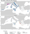
Sampling stations analysed (top map) and stations in which Isidella elongata was detected (bottom map) in the Mediterranean Sea, by data source. Created using ggplot2 version 3.4.4 https://cran.r-project.org/web/packages/ggplot2/index.html within the R environnement (R Core Team).
Figure 3
Figure 3
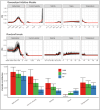
Modelled predictors variable summary Top: Response plots by algorithm, with black lines representing the retained model response and the red line showing a LOESS estimate of the mean response for visualization purpose. Bottom: Mean and standard deviation of predictor contribution to retained models by algorithms. Created using ggplot2 version 3.4.4 https://cran.r-project.org/web/packages/ggplot2/index.html within the R environnement (R Core Team).
Figure 4
Figure 4
Isidella elongata habitat suitability index from the ensemble model at present day (top) and 2100 (bottom) according to the RCP 8.5 IPCC scenario. Created using ggplot2 version 3.4.4 https://cran.r-project.org/web/packages/ggplot2/index.html within the R environnement (R Core Team).
Figure 5
Figure 5
Suitable habitats evolution of Isidella elongata in the Mediterranean Sea as predicted by the ensemble model for the expected climate conditions in 2100. Created using ggplot2 version 3.4.4 https://cran.r-project.org/web/packages/ggplot2/index.html within the R environnement (R Core Team).
Figure 6
Figure 6
Uncertainty maps of the ensemble model, by algorithm disagreement (A, B) and calibration uncertainty (C, D), for current conditions (left column) and RCP 8.5 (right column). Created using ggplot2 version 3.4.4 https://cran.r-project.org/web/packages/ggplot2/index.html within the R environnement (R Core Team).
Figure 7
Figure 7
Comparation between modelled suitability and interpolated occurrence, for (A) suitable habitats and (B) unsuitable habitats. Green represents agreement, red disagreement and blue surveyed areas. Created using ggplot2 version 3.4.4  https://cran.r-project.org/web/packages/ggplot2/index.html within the R environnement (R Core Team).
Figure 8
Figure 8
Overlap of fishery impact analysis on observed presence (A), predicted habitat suitability (B) and predicted climate refugia at 2100 (C), with (left) barplots of total surface by risk level in regional seas. Created using ggplot2 version 3.4.4 https://cran.r-project.org/web/packages/ggplot2/index.html within the R environnement (R Core Team).

Similar articles

Cited by

References

    1. FAO. International Guidelines for the Management of Deep-sea Fisheries in the High Seas | GLOBEFISH | Food and Agriculture Organization of the United Nations. 73 https://www.fao.org/in-action/globefish/publications/details-publication... (2009).
    1. Lacharité M, Metaxas A. Early life history of deep-water gorgonian corals may limit their abundance. PLoS ONE. 2013;8:e65394. doi: 10.1371/journal.pone.0065394. - DOI - PMC - PubMed
    1. European Parliament & Council of the european union. Directive 2008/56/EC of the European Parliament and of the Council of 17 June 2008 establishing a framework for community action in the field of marine environmental policy (Marine Strategy Framework Directive) (Text with EEA relevance. (2008).
    1. Proposal for a regulation of the European parliament and of the council on nature restoration. (2022).
    1. Mytilineou Ch, et al. New cold-water coral occurrences in the Eastern Ionian Sea: Results from experimental long line fishing. Deep Sea Res. Part II. 2014;99:146–157. doi: 10.1016/j.dsr2.2013.07.007. - DOI