

A deep inverse convolutional neural network-based semantic classification method for land cover remote sensing images
- PMID: 38538749
- PMCID: PMC10973368
- DOI: 10.1038/s41598-024-57408-0
A deep inverse convolutional neural network-based semantic classification method for land cover remote sensing images
Abstract
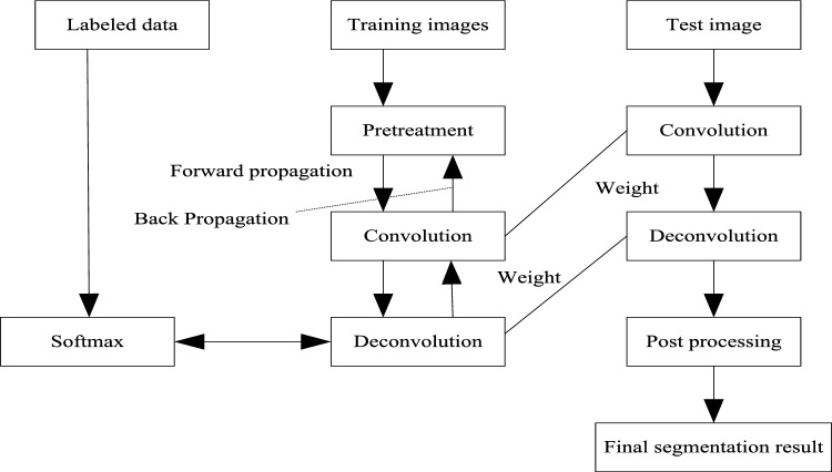
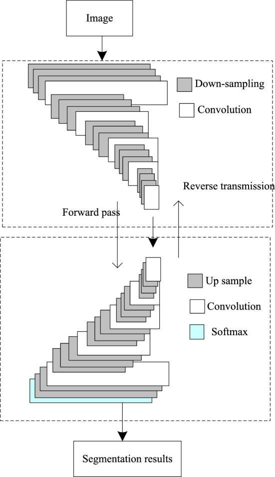
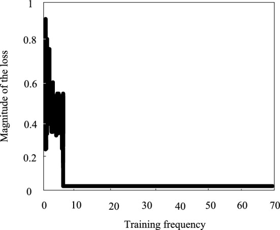
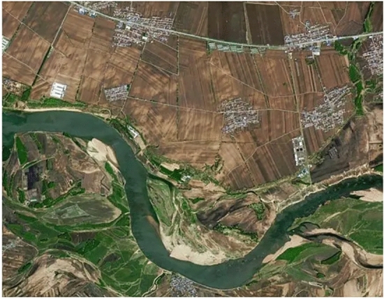
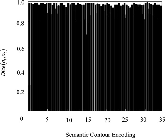
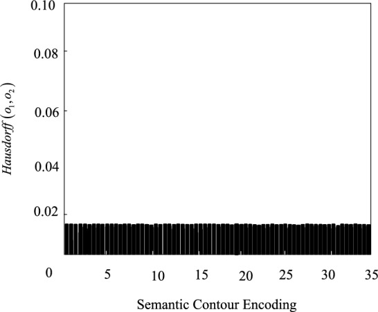
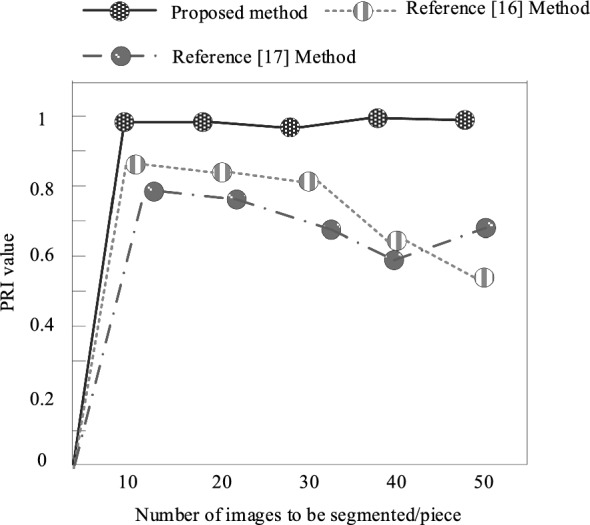
The imbalance of land cover categories is a common problem. Some categories appear less frequently in the image, while others may occupy the vast majority of the proportion. This imbalance can lead the classifier to tend to predict categories with higher frequency of occurrence, while the recognition effect on minority categories is poor. In view of the difficulty of land cover remote sensing image multi-target semantic classification, a semantic classification method of land cover remote sensing image based on depth deconvolution neural network is proposed. In this method, the land cover remote sensing image semantic segmentation algorithm based on depth deconvolution neural network is used to segment the land cover remote sensing image with multi-target semantic segmentation; Four semantic features of color, texture, shape and size in land cover remote sensing image are extracted by using the semantic feature extraction method of remote sensing image based on improved sequential clustering algorithm; The classification and recognition method of remote sensing image semantic features based on random forest algorithm is adopted to classify and identify four semantic feature types of land cover remote sensing image, and realize the semantic classification of land cover remote sensing image. The experimental results show that after this method classifies the multi-target semantic types of land cover remote sensing images, the average values of Dice similarity coefficient and Hausdorff distance are 0.9877 and 0.9911 respectively, which can accurately classify the multi-target semantic types of land cover remote sensing images.
Keywords: Deep inverse convolutional neural network; Feature extraction; Land cover; Remote sensing images; Semantic classification; Semantic segmentation.
© 2024. The Author(s).
Conflict of interest statement
The authors declare no competing interests.
Figures


References
-
- Qinghui L, Michael K, Robert J, Salberg AB. Multi-modal land cover mapping of remote sensing images using pyramid attention and gated fusion networks. Int. J. Remote Sens. 2022;43(9/10):386–412.
-
- Demirkan DC, Koz A, Duzguna HS. Hierarchical classification of Sentinel 2-a images for land use and land cover mapping and its use for the CORINE system. J. Appl. Remote Sens. 2020;14(2):026524. doi: 10.1117/1.JRS.14.026524. - DOI
-
- Coronado A, Moctezuma D. Feature evaluation for land use and land cover classification based on statistical, textural, and shape features over Landsat and Sentinel imagery. J. Appl. Remote Sens. 2020;14(4):048503. doi: 10.1117/1.JRS.14.048503. - DOI
-
- Mohammad R, Stuart R, Phinn CM, Roelfsema A, Abdul A. Modeling forest cover dynamics in Bangladesh using multilayer perceptron neural network with Markov chain. J. Appl. Remote Sens. 2022;16(3):034502.
-
- Jorgen AA, Luigi T, Luppino SNA, Jane UJ. Toward targeted change detection with heterogeneous remote sensing images for forest mortality mapping. Can. J. Remote Sens. 2022;48(6):826–848. doi: 10.1080/07038992.2022.2135497. - DOI
LinkOut - more resources
Full Text Sources
