

A Novel Machine Learning-Based ANFIS Calibrated RISS/GNSS Integration for Improved Navigation in Urban Environments
- PMID: 38544248
- PMCID: PMC10974180
- DOI: 10.3390/s24061985
A Novel Machine Learning-Based ANFIS Calibrated RISS/GNSS Integration for Improved Navigation in Urban Environments
Abstract
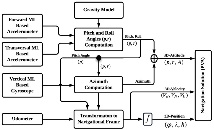
Autonomous vehicles (AVs) require accurate navigation, but the reliability of Global Navigation Satellite Systems (GNSS) can be degraded by signal blockage and multipath interference in urban areas. Therefore, a navigation system that integrates a calibrated Reduced Inertial Sensors System (RISS) with GNSS is proposed. The system employs a machine-learning-based Adaptive Neuro-Fuzzy Inference System (ANFIS) as a novel calibration technique to improve the accuracy and reliability of the RISS. The ANFIS-based RISS/GNSS integration provides a more precise navigation solution in such environments. The effectiveness of the proposed integration scheme was validated by conducting tests using real road trajectory and simulated GNSS outages ranging from 50 to 150 s. The results demonstrate a significant improvement in 2D position Root Mean Square Error (RMSE) of 43.8% and 28% compared to the traditional RISS/GNSS and the frequency modulated continuous wave (FMCW) Radar (Rad)/RISS/GNSS integrated navigation systems, respectively. Moreover, an improvement of 47.5% and 23.4% in 2D position maximum errors is achieved compared to the RISS/GNSS and the Rad/RISS/GNSS integrated navigation systems, respectively. These results reveal significant improvements in positioning accuracy, which is essential for safe and efficient navigation. The long-term stability of the proposed system makes it suitable for various navigation applications, particularly those requiring continuous and precise positioning information. The ANFIS-based approach used in the proposed system is extendable to other low-end IMUs, making it an attractive option for a wide range of applications.
Keywords: ANFIS; GNSS; INS; INS/GNSS integration; MEMS-IMU; RISS; autonomous vehicle navigation; machine learning.
Conflict of interest statement
The authors declare no conflicts of interest.
Figures


References
-
- Skog I., Händel P. In-car positioning and navigation technologiesa survey. IEEE Trans. Intell. Transp. Syst. 2009;10:4–21. doi: 10.1109/TITS.2008.2011712. - DOI
-
- Ayala R., Khan Mohd T. Sensors in Autonomous Vehicles: A Survey. J. Auton. Veh. Syst. 2021;1:1–16. doi: 10.1115/1.4052991. - DOI
-
- Šipoš M., Rohac J., Nováček P. Improvement of Electronic Compass Accuracy Based on Magnetometer and Accelerometer Calibration. Acta Phys. Pol. A. 2012;121:945–949. doi: 10.12693/APhysPolA.121.945. - DOI
-
- Aftatah M., Lahrech A., Abounada A. Fusion of GPS/INS/Odometer measurements for land vehicle navigation with GPS outage; Proceedings of the 2016 2nd International Conference on Cloud Computing Technologies and Applications (CloudTech); Marrakech, Morocco. 24–26 May 2016; Piscataway, NJ, USA: IEEE; 2016. pp. 48–55. - DOI
LinkOut - more resources
Full Text Sources
