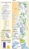
Israel's spatial and a-spatial strategy of dispossessing the Jordan Valley's Palestinian Inhabitants
- PMID: 38625199
- PMCID: PMC10122447
- DOI: 10.1007/s10708-023-10876-9
Israel's spatial and a-spatial strategy of dispossessing the Jordan Valley's Palestinian Inhabitants
Abstract
The Jordan Valley's territorial extent is defined for this study as an elongated stretch of border area, located west of Jordan's boundary with the West Bank, Palestine. This region along with the West Bank was conquered by the Israeli Army during the June 1967 War and has been held by Israel since. Almost 88% of its 200,000 Palestinian population then living in the region were expelled and turned overnight into refugees in Jordan and elsewhere. In the subsequent 56 years since, the region, declared by Israel as a highly militarized zone, has often been discursively publicized as the front line of Israel's eastern defense. This paper seeks to refute such a notion that indirectly gave Israel justification to subject the remaining Palestinian inhabitants residing there (currently numbering ca. 60,000) to a harsh discriminatory regimen of surveillance and control under military occupation. At the same time, the Israeli government has over decades privileged the ca. 10,000 incoming Jewish settlers, now living in some 30 Israeli Jewish settlements in the Jordan Valley. Employing a grounded theory approach in our study provided an opportunity for the local Palestinians to have their voices heard, shedding needed analytical light on their difficult situation on the ground.
Keywords: Israeli spatial control and land uses; Jordan Valley; Occupation; Palestine; Palestinian natives.
© The Author(s), under exclusive licence to Springer Nature B.V. 2023, Springer Nature or its licensor (e.g. a society or other partner) holds exclusive rights to this article under a publishing agreement with the author(s) or other rightsholder(s); author self-archiving of the accepted manuscript version of this article is solely governed by the terms of such publishing agreement and applicable law.
Conflict of interest statement
Conflict of interestThe authors declared no potential conflict of interest with respect to the research, authorship, and/or publication of this article.
Figures
References
-
- Al-Botmeh, S. (2014). Implications of the Kerry Framework. Journal of Palestine Studies,43(3), 49–51. 10.1525/jps.2014.43.3.49 - DOI
-
- Bassin, M. (1987). Imperialism and the nation state in Friedrich Ratzel’s political geography. Progress in Human Geography,11(4), 473–495. - DOI
-
- BBC. (2020). Israel rebuked for “Biggest Demolition of Palestinian Homes in Years.” BBC. https://www.bbc.com/news/world-middle-east-54823660.
-
- B’Tselem. (2004). Forbidden roads Israel’s discriminatory road regime in the West Bank. Jerusalem. The Israeli Information Center for Human Rights in the Occupied Territories, Jerusalem. www.btselem.org
-
- B’Tselem. (2006). 13. Feb. 2006: Israel has de facto annexed the Jordan Valley. The Israeli Information Center for Human Rights in the Occupied Territories, Jerusalem, 13 February. https://www.btselem.org/settlements/20060213_annexation_of_the_jordan_va...
LinkOut - more resources
Full Text Sources

