

Using image segmentation models to analyse high-resolution earth observation data: new tools to monitor disease risks in changing environments
- PMID: 38764024
- PMCID: PMC11102859
- DOI: 10.1186/s12942-024-00371-w
Using image segmentation models to analyse high-resolution earth observation data: new tools to monitor disease risks in changing environments
Abstract
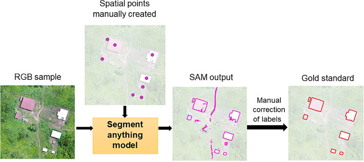
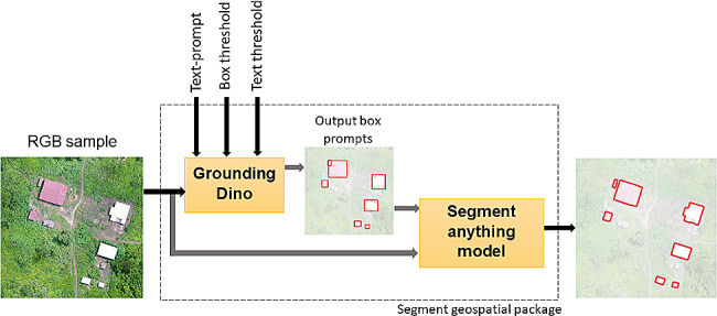
Background: In the near future, the incidence of mosquito-borne diseases may expand to new sites due to changes in temperature and rainfall patterns caused by climate change. Therefore, there is a need to use recent technological advances to improve vector surveillance methodologies. Unoccupied Aerial Vehicles (UAVs), often called drones, have been used to collect high-resolution imagery to map detailed information on mosquito habitats and direct control measures to specific areas. Supervised classification approaches have been largely used to automatically detect vector habitats. However, manual data labelling for model training limits their use for rapid responses. Open-source foundation models such as the Meta AI Segment Anything Model (SAM) can facilitate the manual digitalization of high-resolution images. This pre-trained model can assist in extracting features of interest in a diverse range of images. Here, we evaluated the performance of SAM through the Samgeo package, a Python-based wrapper for geospatial data, as it has not been applied to analyse remote sensing images for epidemiological studies.
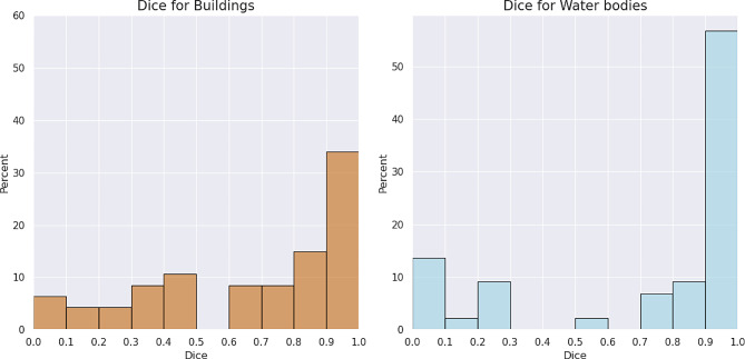
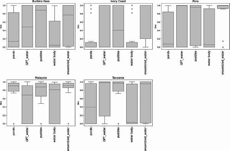
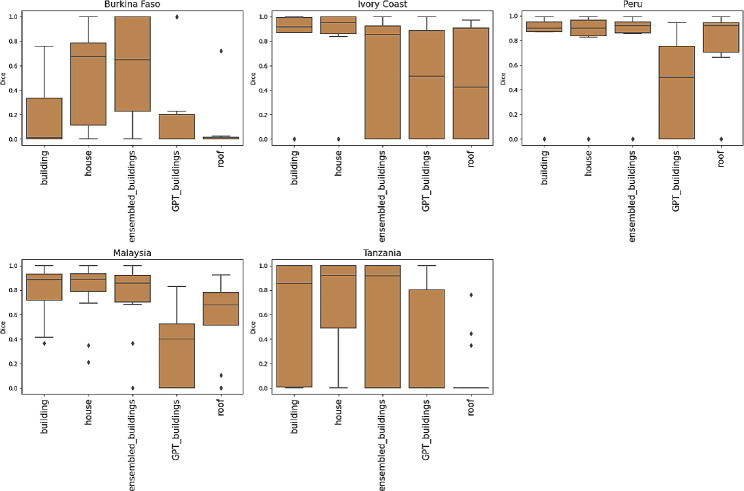
Results: We tested the identification of two land cover classes of interest: water bodies and human settlements, using different UAV acquired imagery across five malaria-endemic areas in Africa, South America, and Southeast Asia. We employed manually placed point prompts and text prompts associated with specific classes of interest to guide the image segmentation and assessed the performance in the different geographic contexts. An average Dice coefficient value of 0.67 was obtained for buildings segmentation and 0.73 for water bodies using point prompts. Regarding the use of text prompts, the highest Dice coefficient value reached 0.72 for buildings and 0.70 for water bodies. Nevertheless, the performance was closely dependent on each object, landscape characteristics and selected words, resulting in varying performance.
Conclusions: Recent models such as SAM can potentially assist manual digitalization of imagery by vector control programs, quickly identifying key features when surveying an area of interest. However, accurate segmentation still requires user-provided manual prompts and corrections to obtain precise segmentation. Further evaluations are necessary, especially for applications in rural areas.
Keywords: Drone; Mosquito-borne diseases; Remote sensing.; Segment anything model; UAV.
© 2024. The Author(s).
Conflict of interest statement
The authors declare no competing interests.
Figures


Similar articles
-
A segment anything model-guided and match-based semi-supervised segmentation framework for medical imaging.Med Phys. 2025 Jun;52(6):4513-4527. doi: 10.1002/mp.17785. Epub 2025 Mar 29. Med Phys. 2025. PMID: 40156370 Free PMC article.
-
[Volume and health outcomes: evidence from systematic reviews and from evaluation of Italian hospital data].Epidemiol Prev. 2013 Mar-Jun;37(2-3 Suppl 2):1-100. Epidemiol Prev. 2013. PMID: 23851286 Italian.
-
Automated devices for identifying peripheral arterial disease in people with leg ulceration: an evidence synthesis and cost-effectiveness analysis.Health Technol Assess. 2024 Aug;28(37):1-158. doi: 10.3310/TWCG3912. Health Technol Assess. 2024. PMID: 39186036 Free PMC article.
-
Management of urinary stones by experts in stone disease (ESD 2025).Arch Ital Urol Androl. 2025 Jun 30;97(2):14085. doi: 10.4081/aiua.2025.14085. Epub 2025 Jun 30. Arch Ital Urol Androl. 2025. PMID: 40583613 Review.
-
Short-Term Memory Impairment.2024 Jun 8. In: StatPearls [Internet]. Treasure Island (FL): StatPearls Publishing; 2025 Jan–. 2024 Jun 8. In: StatPearls [Internet]. Treasure Island (FL): StatPearls Publishing; 2025 Jan–. PMID: 31424720 Free Books & Documents.
References
-
- de Souza WM, Weaver SC. Effects of climate change and human activities on vector-borne diseases. Nat Rev Microbiol 2024. - PubMed
-
- Gibb R, Colon-Gonzalez FJ, Lan PT, Huong PT, Nam VS, Duoc VT, Hung DT, Dong NT, Chien VC, Trang LTT, et al. Interactions between climate change, urban infrastructure and mobility are driving dengue emergence in Vietnam. Nat Commun. 2023;14(1):8179. doi: 10.1038/s41467-023-43954-0. - DOI - PMC - PubMed
-
- Xu Y, Zhou J, Liu T, Liu P, Wu Y, Lai Z, Gu J, Chen X. Assessing the risk of spread of Zika virus under current and future climate scenarios. Biosaf Health. 2022;4(3):193–204. doi: 10.1016/j.bsheal.2022.03.012. - DOI
-
- Marques R, Kruger RF, Cunha SK, Silveira AS, Alves D, Rodrigues GD, Peterson AT, Jimenez-Garcia D. Climate change impacts on Anopheles (K.) cruzii in urban areas of Atlantic Forest of Brazil: challenges for malaria diseases. Acta Trop. 2021;224:106123. doi: 10.1016/j.actatropica.2021.106123. - DOI - PubMed
Publication types
MeSH terms
Grants and funding
LinkOut - more resources
Full Text Sources
Other Literature Sources
Medical
