. 2024 May 22;14(1):11655.
doi: 10.1038/s41598-024-62538-6.

A new continental hydrogen play in Damara Belt (Namibia)

Affiliations

A new continental hydrogen play in Damara Belt (Namibia)

V Roche et al. Sci Rep. .

Abstract

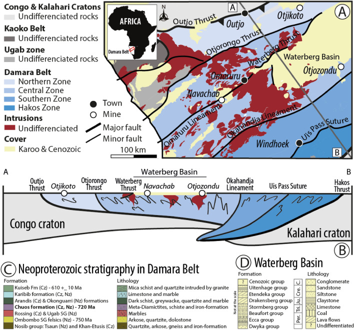
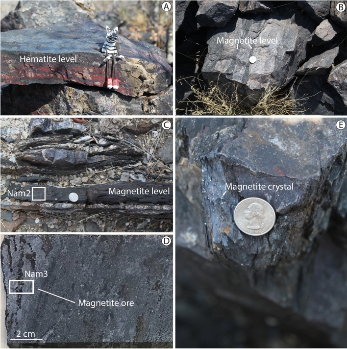
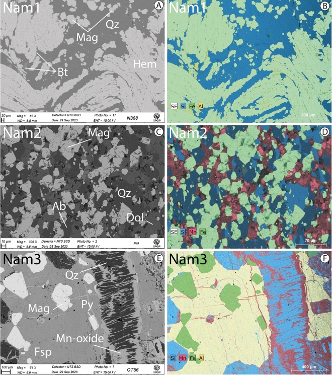
Serpentinization is commonly presented as the main source of natural hydrogen (H2) in the continental domains. However, recent works in Australia and Brazil showed that Archean-Paleoproterozoic banded iron formations could be another natural source of H2 gas. Although the reaction that produces hydrogen is similar (Fe2+ oxidation-H2O reduction process), the iron content may be higher in banded iron formations than in mafic igneous lithologies, potentially generating H2 more efficiently. Here, we present structural evidence that reported H2 emissions from Waterberg Basin, Namibia are associated with underlying Neoproterozoic banded iron formations-the Chuos Formation. Magnetite, a known H2-generating mineral, is ubiquitous and accompanied by other suspected H2-generating minerals (biotite and siderite) in Chuos Formation. Magnetite occurs either as pervasive cm to dm continuous metamorphic laminations in foliation and fractures planes and/or diffusely disseminated in metachert and metacarbonate levels. From this, we infer that metamorphism does not negatively affect the Fe2+ content that is required to generate hydrogen. H2 seepages in Waterberg Basin suggest that an active H2-generating system may exist at depth and that the presence of potential traps and reservoirs is likely based on field observations.


Conflict of interest statement

The authors declare no competing interests.

Figures

Figure 1
Figure 1
Geological background of Waterberg Basin. (A) Simplified geological map of northern Namibia including Damara Belt (after Ref.). The grey indicates the position of the cross-section in (B). (B) Cross-section modified from Ref.. (C) Stratigraphy and sedimentary log in Damara Belt and (D) in Waterberg Basin. Note that the legends in (C) and (D) do not correspond to the map and profile shown in A and B.
Figure 2
Figure 2
H2 seeps in Waterberg Basin. (A) Density map showing the spatial distribution of the SCDs within Waterberg Basin. The Heatmap plugin uses kernel density estimates and was created using the Free and Open Source QGIS (QGIS.org, %Y. QGIS Geographic Information System. QGIS Association. http://www.qgis.org). More than 2200 SCDs were identified by remote sensing techniques and mapped according to the recognition criterion defined in Lévy et al.. (BD) SCDs onto which the BIOGAS 5000 results of H2 concentration are overlain. SCD1 (B) (location: − 20.651°/17.468°); SCD2 (C) (location: − 20.627°/17.466°); SCD3 (D) (location: − 21.527°/16.633°). Note that H2 concentrations are lower in the center of the structure and higher at its periphery, in line with previous studies,.
Figure 3
Figure 3
Magnetic data and geology of Namibia. Colors shaded Total Magnetic Intensity map from Hutchins and Wackerle (Ref.). The data is a compilation of high-resolution and regional magnetic data. The white lines correspond to the outlines of the high-resolution airborne magnetic/radiometric surveys. Lithologies and faults are identified thanks to the geological maps from the Geological Survey. Note that red stands for positive magnetic anomaly while blue stands for the opposite.
Figure 4
Figure 4
Field pictures showing ironstones. (A) Banded hematite level (location: − 20.30°/15.43°). Foliation strikes NNE-SSW and dips 65°. (B) Block of rock belonging to a 50-m thick succession of iron-rich lithologies (S 70/60). The dark layers contain magnetite (location: − 20.67°/15.14°). (C) Sub-vertical magnetite centimetric level between the dark diamictites (location: − 20.49°/15.34°). Nam2 corresponds to the sample 2. (D) Core sample from the Otjozondu manganese mine (location: − 21.23°/18.04°). The right part of the core sample is less enriched in magnetite. Nam3 corresponds to the sample 3. (E) Crystals of magnetite in fracture plane (location: − 20.30°/15.43°).
Figure 5
Figure 5
Back-scattered electron images and related elementary mapping of the three representative rock samples. (A,B) Paragenesis of sample Nam1. Hematite (Hem) ore comprising layers of densely packed hematite elongated and folded whereas magnetite (Mag) comprising small aggregated anhedral crystals. Biotite (Bt) contains also Fe2+—sample Nam1 (location: − 20.46°/15.27°). Quartz (Qz). (C,D) sample Nam2 is mainly composed of octahedral and anhedral crystals of magnetite. Other minerals present are albite (Ab), dolomite (Dol), and quartz. Note that dolomite is Fe2+-enriched according to our ICP-AES and the titration results—sample Nam2 (location: − 20.49°/15.34°). (E,F) sample Nam3 is from the Otjozondu manganese mine and consists of randomly oriented porphyroblasts Mn-rich magnetite, quartz, feldspars (Fsp), and pyrite (Py). Such an assemblage is crosscut by quartz veins bearing Mn-oxide precipitates—sample Nam3 (location: − 21.23°/18.04°).
Figure 6
Figure 6
Main lithologies of interest for a inferred H2 system. (A) Aeolian sandstones defining Waterberg Plateau (location: − 20.51°/17.24°). (B) Sill of dolerite outcropping at the edge of the basin (location: − 21.51°/16.58°). (C,D) Example calcrete sample observed in Waterberg Basin. Paragenesis is composed of calcite (Cal) including clasts of Ab and Qz. Reflected light image (C) and related elemental mapping (D).
Figure 7
Figure 7
Conceptual model of the inferred H2 system. Waterberg fault is indicated by a thick black line and other faults by a thin black dotted line that corresponds to faults from the study of Granath et al.. Unfortunately, there is no seismic data in the basin so the position and the role of faults on fluid circulation is unknown.

References

    1. Prinzhofer A, Cissé CST, Diallo AB. Discovery of a large accumulation of natural hydrogen in Bourakebougou (Mali) Int. J. Hydrog. Energy. 2018;43(42):19315–19326. doi: 10.1016/j.ijhydene.2018.08.193. - DOI
    1. Maiga O, Deville E, Laval J, Prinzhofer A, Diallo AB. Characterization of the spontaneously recharging natural hydrogen reservoirs of Bourakebougou in Mali. Sci. Rep. 2023;13(1):11876. doi: 10.1038/s41598-023-38977-y. - DOI - PMC - PubMed
    1. Klein F, Tarnas JD, Bach W. Abiotic sources of molecular hydrogen on Earth. Elem. Int. Mag. Miner. Geochem. Pet. 2020;16(1):19–24. doi: 10.2138/gselements.16.1.19. - DOI
    1. Zgonnik V. The occurrence and geoscience of natural hydrogen: A comprehensive review. Earth Sci. Rev. 2020;203:103140. doi: 10.1016/j.earscirev.2020.103140. - DOI
    1. Lévy D, Roche V, Pasquet G, Combaudon V, Geymond U, Loiseau K, Moretti I. Natural H2 exploration: Tools and workflows to characterize a play. STET. 2023 doi: 10.2516/stet/2023021. - DOI