

ANN-Based LiDAR Positioning System for B5G
- PMID: 38793193
- PMCID: PMC11122767
- DOI: 10.3390/mi15050620
ANN-Based LiDAR Positioning System for B5G
Abstract
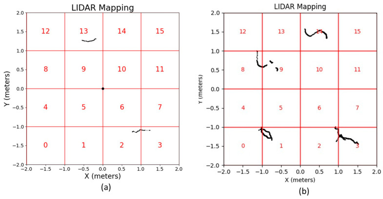
This work reports the development of an efficient and precise indoor positioning system utilizing two-dimensional (2D) light detection and ranging (LiDAR) technology, aiming to address the challenging sensing and positioning requirements of the beyond fifth-generation (B5G) mobile networks. The core of this work is the implementation of a 2D-LiDAR system enhanced by an artificial neural network (ANN), chosen due to its robustness against electromagnetic interference and higher accuracy over traditional radiofrequency signal-based methods. The proposed system uses 2D-LiDAR sensors for data acquisition and digital filters for signal improvement. Moreover, a camera and an image-processing algorithm are used to automate the labeling of samples that will be used to train the ANN by means of indicating the regions where the pedestrians are positioned. This accurate positioning information is essential for the optimization of B5G network operation, including the control of antenna arrays and reconfigurable intelligent surfaces (RIS). The experimental validation demonstrates the efficiency of mapping pedestrian locations with a precision of up to 98.787%, accuracy of 95.25%, recall of 98.537%, and an F1 score of 98.571%. These results show that the proposed system has the potential to solve the problem of sensing and positioning in indoor environments with high reliability and accuracy.
Keywords: 2D-LiDAR; 6G; B5G; artificial neural network; positioning; sensing.
Conflict of interest statement
The authors declare no conflicts of interest.
Figures


References
-
- De Vriendt J., Laine P., Lerouge C., Xu X. Mobile network evolution: A revolution on the move. IEEE Commun. Mag. 2002;40:104–111. doi: 10.1109/35.995858. - DOI
-
- Dahlman E., Gudmundson B., Nilsson M., Skold A. UMTS/IMT-2000 based on wideband CDMA. IEEE Commun. Mag. 1998;36:70–80. doi: 10.1109/35.714620. - DOI
-
- Astely D., Dahlman E., Furuskär A., Jading Y., Lindström M., Parkvall S. LTE: The evolution of mobile broadband. IEEE Commun. Mag. 2009;47:44–51. doi: 10.1109/MCOM.2009.4907406. - DOI
-
- Popovski P., Trillingsgaard K.F., Simeone O., Durisi G. 5G Wireless Network Slicing for eMBB, URLLC, and mMTC: A Communication-Theoretic View. IEEE Access. 2018;6:55765–55779. doi: 10.1109/ACCESS.2018.2872781. - DOI
-
- Liyanage M., Gurtov A., Ylianttila M. Software Defined Mobile Networks (SDMN): Beyond LTE Network Architecture. Wiley; Hoboken, NJ, USA: 2015.
LinkOut - more resources
Full Text Sources
