. 2024 May 31;10(22):eado6611.
doi: 10.1126/sciadv.ado6611. Epub 2024 May 31.

Hot spring oases in the periglacial desert as the Last Glacial Maximum refugia for temperate trees in Central Europe

Affiliations

Hot spring oases in the periglacial desert as the Last Glacial Maximum refugia for temperate trees in Central Europe

Jan Hošek et al. Sci Adv. .

Abstract

Northern glacial refugia are a hotly debated concept. The idea that many temperate organisms survived the Last Glacial Maximum (LGM; ~26.5 to 19 thousand years) in several sites across central and northern Europe stems from phylogeographic analyses, yet direct fossil evidence has thus far been missing. Here, we present the first unequivocal proof that thermophilous trees such as oak (Quercus), linden (Tilia), and common ash (Fraxinus excelsior) survived the LGM in Central Europe. The persistence of the refugium was promoted by a steady influx of hydrothermal waters that locally maintained a humid and warm microclimate. We reconstructed the geological and palaeohydrological factors responsible for the emergence of hot springs during the LGM and argue that refugia of this type, allowing the long-term survival and rapid post-LGM dispersal of temperate elements, were not exceptional in the European periglacial zone.


Figures

Fig. 1.
Fig. 1.. European paleoenvironments during the LPG (~28 to 14.7 ka).
The location of the newly recovered deposits in Moravia (red star) and a hydrothermal field in the Liptov Basin (yellow star), along with the distribution of previously investigated sites with macrofossil tree findings dated to the Late Pleniglacial [LPG; modified from (24)]. The maximum extent of glaciers [blue; after (106)] and the southern limit of the permafrost (periglacial) zone [dashed line; after (79)] are also depicted.
Fig. 2.
Fig. 2.. Regional and local geomorphological and geological settings of the Moravian fossil hydrothermal field.
(A) The tectonic overview and bathymetry of the VB [modified from (74, 107)] and the locations of the studied Moravian hydrothermal field [red circle, detailed in (B)] and nearby peat deposits (yellow circle; see Supplementary Materials). (B) Digital Terrain Model showing tens of distinct shallow circular-to-semioval-shaped depressions covering an area of about 50 km2 (red dashed line). (C) A close-up view of the surface topography [yellow colored polygon in (B)] with the marked depressions that were studied in detail. (D) Results of the electrical resistivity tomography (ERT) of three investigated depressions. Distinct low-resistant vertical structures (blue color) point to wet/mineralized zones and suggest the location of the depressions on a fault. (E) Cross section of one of the studied depressions shows a quasi-continuous horizon of silica sinter deposits overlaid by Late Glacial colluvial sediments and aeolian sands.
Fig. 3.
Fig. 3.. Interpreting the depositional environment of the past hydrothermal field in Moravia.
Idealized cross section through the depression hosting the thermal spring, as evident from field and laboratory-based comparisons with modern systems (figs. S19 to S26 and supplementary text C). The thermal water-fed pool is surrounded by a low silica sinter rim, through which the outlet streams flow. The outlet channels provide a habitat for sparse vascular plant vegetation on interfluve. The outlet channels feed the distal wetland with diverse vegetation. Photographs above the sketch show respective habitats as mapped in active hot spring areas of Yellowstone National Park (supplementary text C and fig. S19; research conducted under Yellowstone Research Permit YELL-2022-SCI-7020).
Fig. 4.
Fig. 4.. Stratigraphy and fossil plant records from the late Pleistocene silica sinters.
(A) Frequency distribution of radiocarbon data of organic matter separated from the silica sinter, correlated with the climatostratigraphic record of the time interval of 40 to 10 ka [black curve; the δ18O values of NGRIP; (35)] and the modeled total ice volume of the glacier in the Alps (82) expressed in meters of sea level equivalent (m s.l.e.; blue curve). (B) Pollen record from the silica sinter showing the proportion of arboreal (AP) and non-arboreal (NAP) pollen components (left column) and the proportion of broad-leaved temperate taxa in the overall AP spectra (right column).
Fig. 5.
Fig. 5.. Fragments of leaves preserved in silica sinter compared to recent leaves of common oak (Q. robur).
(A) Basal part of small leaf with preserved main midrib (1), basal part of lamina (2), margin (arrow), and venation showing the position of intercalary vein (3) running to the lobe sinus (specimen KS3C_2). (B) Specimen KS3C_1 showing two leaf fragments with main midrib (1) and secondary veins (2); the larger leaf shows secondary veins leaving the primary vein in sharp angles, and the smaller leaf fragment shows basal part of lamina with partly preserved margin (arrow); for high-resolution images, see fig. S13.
Fig. 6.
Fig. 6.. Two fragments of lobes showing veins running to apex (arrow), typical character of craspedodromous type of venation.
Fig. 7.
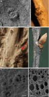
Fig. 7.. Examples of wood fragments preserved in silica sinter.
(A) Scanning electron microscopy (SEM) image of twig with bud identified as F. excelsior (common ash) compared to recent twig of common ash (specimen KS9_fraxinus). (B) The twig with a bud (arrow) identified as Quercus sp. compared to recent twig of common oak (specimen KS3C-1). (C) SEM image showing silicified vessels (transverse section) of Quercus sp. preserved in wood fragment from the twig in (B; red line) in comparison with recent wood of Q. robur.
Fig. 8.
Fig. 8.. Geological and hydroclimatic settings of the LGM refugium in the VB.
(A) Bathymetry of the impermeable pre-Neogene basis of the VB [after (74, 106)] with the major tectonic fault (VBTF, Vienna Basin Transform Fault) (75), and the location of the Moravian refugium (red circle). (B and C) Longitudinal cross sections of the VB along the red line in (A), indicating the geothermal gradients [after (108)], faulting (74, 107), the assumed thickness of permafrost and the Alpine glacier (82, 109), and respective paleobotanical records. An increased inflow of surface and subsurface water during the relatively humid Middle Pleniglacial (MIS 3) (B) percolated along major fault structures and recharged geothermal deep-water circulation systems in depths over 5 km. Cyclic growth and decay of the Alpine glacier, occurring during the late Middle Pleniglacial and especially during the LPG (MIS 2) (C), reactivated main tectonic structures along which hydrothermal fluids emerged as hot springs.

Similar articles

References

    1. Frenzel B., The Pleistocene vegetation of northern Eurasia. Science 161, 637–649 (1968). - PubMed
    1. Bennett K. D., Tzedakis P. C., Willis K. J., Quaternary refugia of North European trees. J. Biogeogr. 18, 103–115 (1991).
    1. Hewitt G. H., The genetic legacy of the Quaternary ice ages. Nature 405, 907–913 (2000). - PubMed
    1. Bilton D. T., Mirol P. M., Mascheretti S., Fredga K., Zima J., Searle J. B., Mediterranean Europe as an area of endemism for small mammals rather than a source for northwards postglacial colonization. Proc. Biol. Sci. 265, 1219–1226 (1998). - PMC - PubMed
    1. Petit R. J., Aguinagalde I., de Beaulieu J.-L., Bittkau C., Brewer S., Cheddadi R., Ennos R., Fineschi S., Grivet D., Lascoux M., Mohanty A., Müller-Starck G., Demesure-Musch B., Palmé A., Martín J. P., Rendell S., Vendramin G. G., Glacial refugia: Hotspots but not melting pots of genetic diversity. Science 300, 1563–1565 (2003). - PubMed