Mapping climate adaptation corridors for biodiversity-A regional-scale case study in Central America
- PMID: 38820545
- PMCID: PMC11142673
- DOI: 10.1371/journal.pone.0304756
Mapping climate adaptation corridors for biodiversity-A regional-scale case study in Central America
Abstract
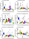
Climate adaptation corridors are widely recognized as important for promoting biodiversity resilience under climate change. Central America is part of the Mesoamerican biodiversity hotspot, but there have been no regional-scale analyses of potential climate adaptation corridors in Central America. We identified 2375 potential corridors throughout Central America that link lowland protected areas (≤ 500 m) with intact, high-elevation forests (≥ 1500 m) that represent potential climate change refugia. Whereas we found potential corridors in all Central American countries, potential corridors in Panama, Belize, and Honduras were most protected (medians = 64%, 49%, and 47%, respectively) and potential corridors in El Salvador were least protected (median = 10%). We also developed a corridor priority index based on the ecological characteristics and protected status of potential corridors and their associated start and end points. Compared to low- and medium-priority corridors, high-priority corridors (n = 160; top 7% of all corridors) were generally more protected, forested, and distributed across wider elevational gradients and more Key Biodiversity Areas, but also generally linked larger lowland protected areas to target areas that were larger, more protected, and spanned wider elevational gradients. For example, based on median values, high-priority corridors were 9% more protected and overlapped with 2-3 more Key Biodiversity Areas than low- and medium-priority corridors. Although high-elevation targets spanned considerably wider elevational gradients than lowland protected areas (medians = 695 vs. 142 m, respectively) and thus may be more likely to support refugia, they were considerably smaller than lowland protected areas (medians = 11 vs. 50 km2 respectively) and mostly unprotected (median = 4% protection). This initial, regional assessment can help prioritize locations for finer-scale research, conservation, and restoration activities in support of climate adaptation corridors throughout Central America and highlights the need for greater conservation of potential high-elevation refugia.
Copyright: © 2024 McCullough et al. This is an open access article distributed under the terms of the Creative Commons Attribution License, which permits unrestricted use, distribution, and reproduction in any medium, provided the original author and source are credited.
Conflict of interest statement
The authors have declared that no competing interests exist.
Figures


Similar articles
-
Identifying riparian climate corridors to inform climate adaptation planning.PLoS One. 2018 Nov 14;13(11):e0205156. doi: 10.1371/journal.pone.0205156. eCollection 2018. PLoS One. 2018. PMID: 30427831 Free PMC article.
-
Distribution and protection of climatic refugia in North America.Conserv Biol. 2018 Dec;32(6):1414-1425. doi: 10.1111/cobi.13130. Epub 2018 Aug 13. Conserv Biol. 2018. PMID: 29744936
-
Scale-dependent complementarity of climatic velocity and environmental diversity for identifying priority areas for conservation under climate change.Glob Chang Biol. 2017 Nov;23(11):4508-4520. doi: 10.1111/gcb.13679. Epub 2017 Mar 31. Glob Chang Biol. 2017. PMID: 28267245
-
Rewilding in the face of climate change.Conserv Biol. 2021 Feb;35(1):155-167. doi: 10.1111/cobi.13531. Epub 2020 Jun 1. Conserv Biol. 2021. PMID: 32557877 Free PMC article. Review.
-
Maximizing the effectiveness of national commitments to protected area expansion for conserving biodiversity and ecosystem carbon under climate change.Glob Chang Biol. 2021 Aug;27(15):3395-3414. doi: 10.1111/gcb.15645. Epub 2021 May 10. Glob Chang Biol. 2021. PMID: 33852186 Free PMC article. Review.
References
-
- Beier P, Noss RF. Do habitat corridors provide connectivity?. Conservation Biology. 1998. Dec;12(6):1241–52.
-
- Heller NE, Zavaleta ES. Biodiversity management in the face of climate change: a review of 22 years of recommendations. Biological conservation. 2009. Jan 1;142(1):14–32.
-
- Costanza JK, Terando AJ. Landscape connectivity planning for adaptation to future climate and land-use change. Current Landscape Ecology Reports. 2019. Mar;4:1–3.
-
- Littlefield CE, Krosby M, Michalak JL, Lawler JJ. Connectivity for species on the move: supporting climate‐driven range shifts. Frontiers in Ecology and the Environment. 2019. Jun;17(5):270–8.
-
- Hilty J, Worboys GL, Keeley A, Woodley S, Lausche B, Locke H, et al.. 2020. Guidelines for conserving connectivity through ecological networks and corridors. Best Practice Protected Area Guidelines Series No. 30. Gland, Switzerland: IUCN.
MeSH terms
LinkOut - more resources
Full Text Sources
Medical

