

Microclimate factors related to dengue virus burden clusters in two endemic towns of Mexico
- PMID: 38843173
- PMCID: PMC11156286
- DOI: 10.1371/journal.pone.0302025
Microclimate factors related to dengue virus burden clusters in two endemic towns of Mexico
Abstract
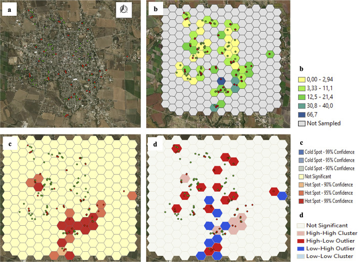
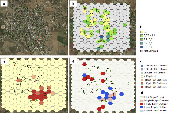
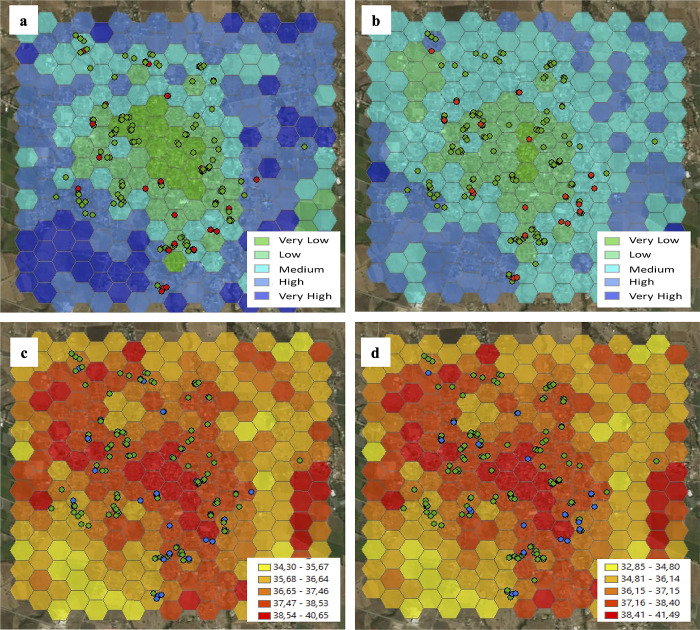
In dengue-endemic areas, transmission control is limited by the difficulty of achieving sufficient coverage and sustainability of interventions. To maximize the effectiveness of interventions, areas with higher transmission could be identified and prioritized. The aim was to identify burden clusters of Dengue virus (DENV) infection and evaluate their association with microclimatic factors in two endemic towns from southern Mexico. Information from a prospective population cohort study (2·5 years of follow-up) was used, microclimatic variables were calculated from satellite information, and a cross-sectional design was conducted to evaluate the relationship between the outcome and microclimatic variables in the five surveys. Spatial clustering was observed in specific geographic areas at different periods. Both, land surface temperature (aPR 0·945; IC95% 0·895-0·996) and soil humidity (aPR 3·018; IC95% 1·013-8·994), were independently associated with DENV burden clusters. These findings can help health authorities design focused dengue surveillance and control activities in dengue endemic areas.
Copyright: © 2024 Tapias-Rivera et al. This is an open access article distributed under the terms of the Creative Commons Attribution License, which permits unrestricted use, distribution, and reproduction in any medium, provided the original author and source are credited.
Conflict of interest statement
FAD-Q declares grants from the Brazilian National Council for Scientific and Technological Development – CNPq and Sanofi Pasteur not related to this work. JR-C declares grant support to develop the cohort from which data are taken and funded by Sanofi Pasteur DNG 22 (Dengue seroprevalence, neutralizing titers and incidence in an endemic population of Morelos State, Mexico); payment for expert testimony from Takeda and support for attending meetings and/or travel by Sanofi Pasteur not related to this work. RAM-V reports honoraria and travel expenses as a consultant for the project from which the primary data were obtained by the National Institute of Public Health. Mexico and funded by Sanofi Pasteur DGN 22. IYA-L reports honoraria as coordinator of the project from which the primary data were obtained by the National Institute of Public Health. Mexico and funded by Sanofi Pasteur DNG 22. JT-P, SR-P and RS-L have no conflict of interest to declare. This does not alter our adherence to PLOS ONE policies on sharing data and materials.
Figures
Similar articles
-
Spatial dimensions of dengue virus transmission across interepidemic and epidemic periods in Iquitos, Peru (1999-2003).PLoS Negl Trop Dis. 2012;6(2):e1472. doi: 10.1371/journal.pntd.0001472. Epub 2012 Feb 21. PLoS Negl Trop Dis. 2012. PMID: 22363822 Free PMC article.
-
Spatial and temporal clustering of dengue virus transmission in Thai villages.PLoS Med. 2008 Nov 4;5(11):e205. doi: 10.1371/journal.pmed.0050205. PLoS Med. 2008. PMID: 18986209 Free PMC article.
-
Heterogeneity of dengue transmission in an endemic area of Colombia.PLoS Negl Trop Dis. 2020 Sep 14;14(9):e0008122. doi: 10.1371/journal.pntd.0008122. eCollection 2020 Sep. PLoS Negl Trop Dis. 2020. PMID: 32925978 Free PMC article.
-
Impact of the introduction of chikungunya and zika viruses on the incidence of dengue in endemic zones of Mexico.PLoS Negl Trop Dis. 2021 Dec 2;15(12):e0009922. doi: 10.1371/journal.pntd.0009922. eCollection 2021 Dec. PLoS Negl Trop Dis. 2021. PMID: 34855759 Free PMC article.
-
[Population genetics of dengue virus and transmission of dengue fever].Salud Publica Mex. 2009;51 Suppl 3:S403-9. doi: 10.1590/s0036-36342009000900006. Salud Publica Mex. 2009. PMID: 20464214 Review. Spanish.
References
-
- Organization WH. Dengue and severe dengue Geneva, Switzerland2023 [cited 2023 03/14/2023]. Available from: https://www.who.int/news-room/fact-sheets/detail/dengue-and-severe-dengue.
-
- Organization PAH. PLISA Health Information Platform for the Americas: Dengue Whasington D.C. USA2023 [cited 2023 03/14/2023]. Available from: https://www3.paho.org/data/index.php/en/mnu-topics/indicadores-dengue-en....
-
- Martinez-Vega RA, Danis-Lozano R, Diaz-Quijano FA, Velasco-Hernandez J, Santos-Luna R, Roman-Perez S, et al.. Peridomestic Infection as a Determining Factor of Dengue Transmission. PLoS Negl Trop Dis. 2015;9(12):e0004296. Epub 20151215. doi: 10.1371/journal.pntd.0004296 ; PubMed Central PMCID: PMC4684393. - DOI - PMC - PubMed
MeSH terms
LinkOut - more resources
Full Text Sources
Medical
Miscellaneous
