Drivers of autochthonous malaria cases over time: could the Central European present the African future?
- PMID: 38858778
- PMCID: PMC11163750
- DOI: 10.1186/s12936-024-05004-y
Drivers of autochthonous malaria cases over time: could the Central European present the African future?
Abstract
Background: Results of spatial and temporal comparison of malaria hotspots and coldspots could improve the health measures of malaria control and eradication strategies. The study aimed to reveal the spatially and temporally independent correlations between the potentially most effective background variables and the number of autochthonous malaria cases.
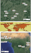
Methods: Relationships between malaria cases and background variables were studied in 2 km × 2 km sized quadrates (10 Central European and 10 African). In addition to the current habitat structure of the African sites, annual precipitation, and annual mean temperature, data of the above parameters detected in the nineteenth and twentieth centuries and currently in the Central European sites were included in the analyses (n = 40). Mann-Whitney tests, Principal Component Analysis, and Generalized Linear Models were used for the examinations.
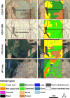
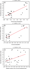
Results: In addition to the apparent significant positive correlation of malaria cases with annual rainfall and mean temperature, several correlations were found for habitat parameters. The cover of marshlands in the 19th-century habitat structure of Central European quadrates was considerably the same as in the recent African ones. The extent of rural residential areas was significantly smaller in the 19th-century habitat structure of Central European quadrats than in present-day African ones. According to the revealed correlations, the surface cover of rural residential areas is the main driver of the number of autochthonous malaria cases that we can directly impact.
Conclusions: The study confirmed with historical comparison that not only the annual rainfall and mean temperature, the cover of marshlands and other habitats with breeding sites, but also the elements of the rural human environment play a significant role in the high number of autochthonous malaria cases, probably through the concentration and enhancing sites for vector mosquitoes. The latter confirms that a rapid urbanization process could reduce malaria cases in the most infected areas of Africa. Until the latter happens, extensive biological control of Anopheles larvae and chemical control (both outdoor and indoor) of their imagoes, further mosquito nets, repellents, and carbon dioxide traps will need to be applied more widely in the most heavily infested areas.
Keywords: Aerial photographs; Drainage; Marshland; Nineteenth century; QGIS; Rural; Urban.
© 2024. The Author(s).
Conflict of interest statement
I declare i have no competing interests.
Figures


Similar articles
-
[Current malaria situation in the Republic of Kazakhstan].Med Parazitol (Mosk). 2001 Jan-Mar;(1):24-33. Med Parazitol (Mosk). 2001. PMID: 11548308 Russian.
-
Anopheles larval species composition and characterization of breeding habitats in two localities in the Ghibe River Basin, southwestern Ethiopia.Malar J. 2020 Feb 11;19(1):65. doi: 10.1186/s12936-020-3145-8. Malar J. 2020. PMID: 32046734 Free PMC article.
-
[Current malaria situation in Turkmenistan].Med Parazitol (Mosk). 2001 Jan-Mar;(1):37-9. Med Parazitol (Mosk). 2001. PMID: 11548312 Russian.
-
The behaviour of adult Anopheles gambiae, sub-Saharan Africa's principal malaria vector, and its relevance to malaria control: a review.Malar J. 2024 May 23;23(1):161. doi: 10.1186/s12936-024-04982-3. Malar J. 2024. PMID: 38783348 Free PMC article. Review.
-
Piperonyl butoxide (PBO) combined with pyrethroids in insecticide-treated nets to prevent malaria in Africa.Cochrane Database Syst Rev. 2021 May 24;5(5):CD012776. doi: 10.1002/14651858.CD012776.pub3. Cochrane Database Syst Rev. 2021. PMID: 34027998 Free PMC article.
References
-
- WHO Malaria, 1982–1997. Weekly Epidem Rec. 1999;74:265–70.
MeSH terms
LinkOut - more resources
Full Text Sources
Medical

