

An assessment of uncontrolled human interventions on the contemporary sediment budget and morphological alterations of the Vu Gia Thu Bon River basin, central Vietnam
- PMID: 38868035
- PMCID: PMC11168294
- DOI: 10.1016/j.heliyon.2024.e31476
An assessment of uncontrolled human interventions on the contemporary sediment budget and morphological alterations of the Vu Gia Thu Bon River basin, central Vietnam
Abstract
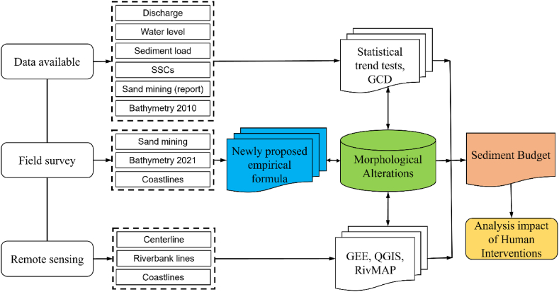
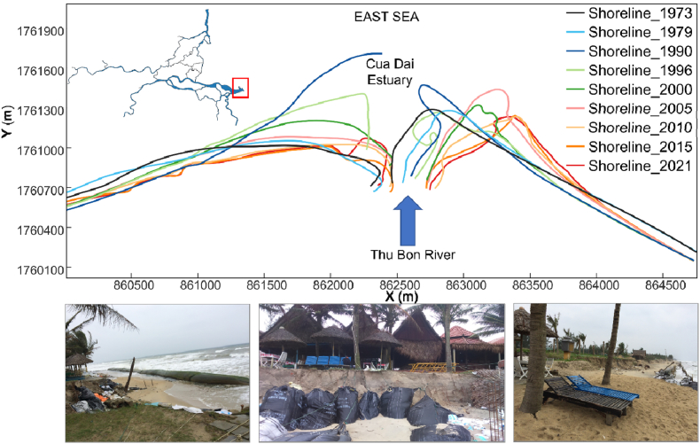
The Vu Gia Thu Bon (VGTB) River basin is critical for regional development and prosperity in water resources. However, human interventions (e.g., dam construction and sand mining) have significantly affected this basin's sediment budget and morphological alterations over recent decades. Such humane actions drive an imbalance in water resources in the basin from upstream to downstream. Therefore, this study investigated spatiotemporal changes in sediment budget and morphology alterations using long-term data and bathymetric surveys; from these data, dams and sand mining contributions were quantified and differentiated. Based on field survey data and interviews, we estimated the sand-mining volume by incorporating reported and a newly proposed empirical formula. The results show that the total riverbed incision volume from 2010 to 2021 was 63.30 Mm3, with an incision rate of 0.14 m/yr. The officially reported sand-mining rate was 1.12 Mm3/yr, while the newly proposed empirical formula estimated 4.4 Mm3/yr. According to the developed empirical formula, the percentage reductions in the sediment budget due to sand mining and upstream dams were 69.7 % and 30.3 %, respectively, according to reports, and 17.8 % and 82.2 %. The statistical method was thus likely too conservative compared to the developed empirical formula. We found that the natural sediment supplies sourced from upstream were insufficient to compensate for the mined bed material. Therefore, our combination of different datasets permitted the assessment of future geomorphological developments within the VGTB River basin under the ongoing sediment deficits. The results of this study provide valuable insights into the impacts of human interventions, specifically sand mining, on the sediment budget, morphological alterations, and riverbed incision. The developed assessment forms the foundation for developing and expanding the region's water/sediment resource management strategies.
Keywords: Dam construction; Morphological alterations; Newly proposed empirical formula; Sand mining; Sediment budget; Vu Gia Thu Bon River basin.
© 2024 The Authors.
Conflict of interest statement
The authors declare that they have no known competing financial interests or personal relationships that could have appeared to influence the work reported in this paper.
Figures


Similar articles
-
Quantifying the consequences of unsustainable sand mining and cascade dams on aspects in a tropical river basin.Sci Rep. 2024 Jan 12;14(1):1178. doi: 10.1038/s41598-024-51405-z. Sci Rep. 2024. PMID: 38216700 Free PMC article.
-
Long-term assessment of hydropeaking and cumulative impacts on sediment transport, grain size dynamics, channel stability and water resource management.J Environ Manage. 2025 Apr;380:124983. doi: 10.1016/j.jenvman.2025.124983. Epub 2025 Mar 16. J Environ Manage. 2025. PMID: 40096809
-
Sand mining in the Mekong Delta revisited - current scales of local sediment deficits.Sci Rep. 2019 Nov 28;9(1):17823. doi: 10.1038/s41598-019-53804-z. Sci Rep. 2019. PMID: 31780684 Free PMC article.
-
Sand mining in the Mekong Delta: Extent and compounded impacts.Sci Total Environ. 2024 May 10;924:171620. doi: 10.1016/j.scitotenv.2024.171620. Epub 2024 Mar 10. Sci Total Environ. 2024. PMID: 38467261 Review.
-
Climate and land-use changes affecting river sediment and brown trout in alpine countries--a review.Environ Sci Pollut Res Int. 2009 Mar;16(2):232-42. doi: 10.1007/s11356-008-0075-3. Epub 2008 Dec 2. Environ Sci Pollut Res Int. 2009. PMID: 19048320 Review.
References
-
- Keesstra S.D., Kondrlova E., Czajka A., Seeger M., Maroulis J. Assessing riparian zone impacts on water and sediment movement: a new approach. Neth. J. Geosci. 2012;91(1–2):245–255.
-
- Syvitski J.P.M., Kettner A.J., Overeem I., Hutton E.W.H., Hannon M.T., Brakenridge G.R., Day J., Vörösmarty C., Saito Y., Giosan L. Sinking deltas due to human activities. Nat. Geosci. 2009;2(10):681–686.
-
- Best J. Anthropogenic stresses on the world's big rivers. Nat. Geosci. 2019;12(1):7–21.
-
- Binh D. Van, Kantoush S.A., Sumi T., Mai N.P., Ngoc T.A., Trung L.V., An T.D. Effects of riverbed incision on the hydrology of the Vietnamese Mekong Delta. Hydrol. Process. 2021;35(2)
-
- Boix-Fayos C., Barberá G.G., López-Bermúdez F., Castillo V.M. Effects of check dams, reforestation and land-use changes on river channel morphology: case study of the Rogativa catchment (Murcia, Spain) Geomorphology. 2007;91(1–2):103–123.
LinkOut - more resources
Full Text Sources
