

Detection of spatial, temporal and spatiotemporal distribution of diarrhea incidence among under-five children in Central Gondar zone, Northwest Ethiopia: a time-series study (2019-2022)
- PMID: 38969969
- PMCID: PMC11225151
- DOI: 10.1186/s12887-024-04900-1
Detection of spatial, temporal and spatiotemporal distribution of diarrhea incidence among under-five children in Central Gondar zone, Northwest Ethiopia: a time-series study (2019-2022)
Abstract
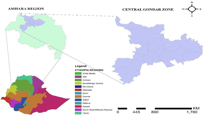
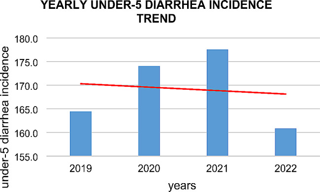
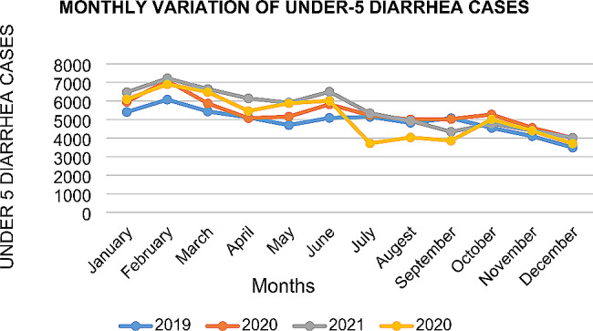
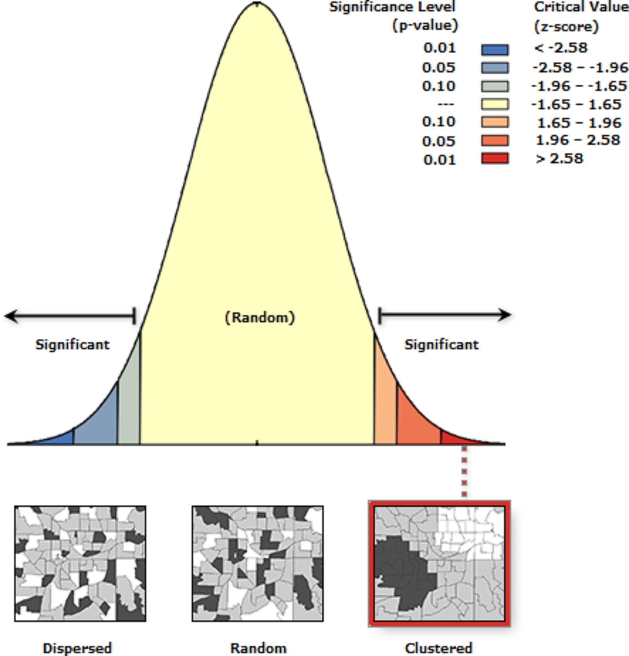
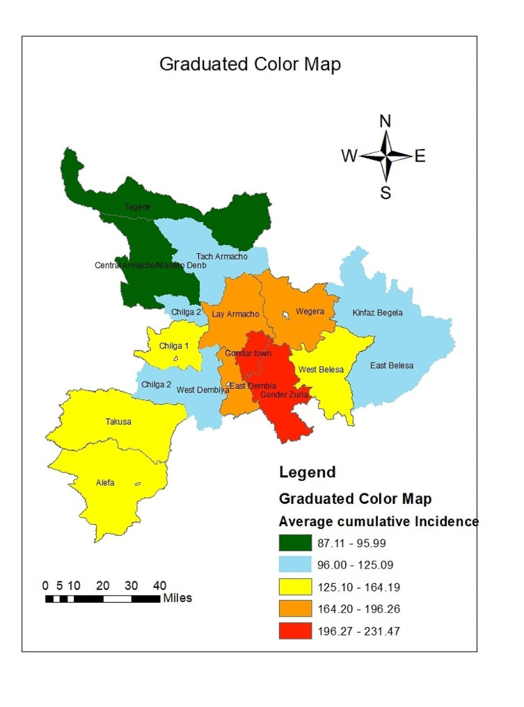
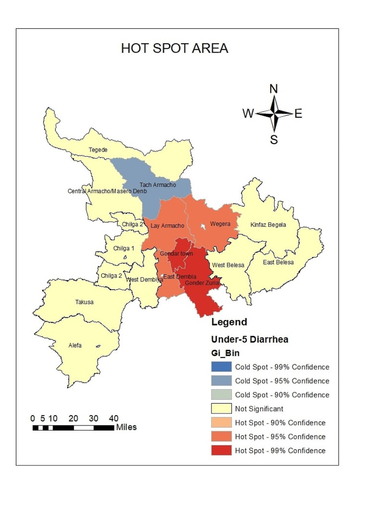
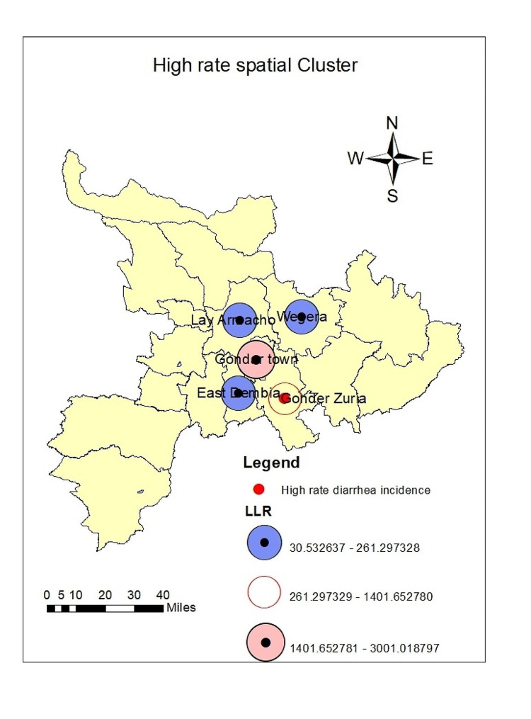
Under-five children's diarrhea is a significant public health threat and the World Health Organization (WHO) reported it as the second leading cause of children's death worldwide. In this study area, little is known about the spatiotemporal distribution of under-5 diarrhea incidence. This study was therefore, conducted among all districts in the Central Gondar zone to assess the spatial, temporal, and spatiotemporal variation in diarrhea incidence among under-five children in the Central Gondar zone. The data for children under 5 years of age with diarrhea was obtained from Central Gondar Zone Health Department diarrhea reports from January 2019 to December 2022. All districts were included and geo-coded. The spatial data were created in ArcGIS 10.8.1. Global and local spatial autocorrelation were used to detect hot spots and cold spots. The Poisson model was generated by applying the Kulldorff method in SaTScan™9.6 to analyse the the purely temporal, spatial, and space-time clusters. The study revealed spatial variation of under-5 diarrhea where Gondar City, Gondar Zuria, East Dembia, and Lay Armacho districts were the high-rate spatial clusters during the study period. A year search window for temporal scan statistic identified 01 January 2020-30 December 2021 as risk periods across all districts. Spatiotemporal scan statistics detected high-rate clusters at Gondar City, Gondar Zuria, East Dembia, Lay Armacho, and Alefa between 2019 and 2022. In conclusion, there has been a spatial, temporal, and spatiotemporal variability of under-5 children's diarrhea in the Central Gondar Zone. Interventional and preventive strategies should be developed and given priority to the areas that has been detected as a hotspot in this study to reduce the mortality and morbidity of under 5 children.
Keywords: Diarrhea incidence; Distribution; Spatial; Spatiotemporal; Temporal; Under-5 children.
© 2024. The Author(s).
Conflict of interest statement
The authors declare no competing interests.
Figures
Similar articles
-
Spatiotemporal variation of under-5 children diarrhea incidence and associated meteorological factors in central Gondar zone, Northwest Ethiopia. A retrospective time series study.BMC Infect Dis. 2025 Mar 19;25(1):380. doi: 10.1186/s12879-025-10772-2. BMC Infect Dis. 2025. PMID: 40108548 Free PMC article.
-
Spatial and temporal variation of pneumonia incidence among under-five children in central gondar zone, Northwest Ethiopia, 2013- 2022.BMC Pediatr. 2025 Mar 11;25(1):182. doi: 10.1186/s12887-025-05550-7. BMC Pediatr. 2025. PMID: 40069711 Free PMC article.
-
Spatiotemporal and hotspot detection of U5-children diarrhea in resource-limited areas of Ethiopia.Sci Rep. 2020 Jul 3;10(1):10997. doi: 10.1038/s41598-020-67623-0. Sci Rep. 2020. PMID: 32620796 Free PMC article.
-
Childhood Diarrhea Exhibits Spatiotemporal Variation in Northwest Ethiopia: A SaTScan Spatial Statistical Analysis.PLoS One. 2015 Dec 21;10(12):e0144690. doi: 10.1371/journal.pone.0144690. eCollection 2015. PLoS One. 2015. PMID: 26690058 Free PMC article.
-
Spatiotemporal Distribution, Time to Treatment Outcome Clustering and Determinants of Esophageal Cancer in Ethiopia, a Scoping Study.Cancer Control. 2024 Jan-Dec;31:10732748241251712. doi: 10.1177/10732748241251712. Cancer Control. 2024. PMID: 38716644 Free PMC article.
Cited by
-
Spatial, temporal, and spatiotemporal cluster detection of malaria incidence in Southwest Ethiopia.Front Public Health. 2025 Jan 13;12:1466610. doi: 10.3389/fpubh.2024.1466610. eCollection 2024. Front Public Health. 2025. PMID: 39872097 Free PMC article.
-
Association of meteorological factors with childhood pneumonia incidence in Central Gondar Zone, Northwest Ethiopia: a time-series study (2013-2022).Ital J Pediatr. 2025 Jul 15;51(1):225. doi: 10.1186/s13052-025-02072-x. Ital J Pediatr. 2025. PMID: 40660351 Free PMC article.
References
-
- Organization WH. Diarrhoea: why children are still dying and what can be done. 2009.
-
- Organization WH. World Health statistics 2016 [OP]: Monitoring Health for the Sustainable Development Goals (SDGs). World Health Organization; 2016.
-
- UNICIEF. DIARRHOEA. 2022.
-
- Organization WH. The treatment of diarrhoea: a manual for physicians and other senior health workers. World Health Organization; 2005. p. 9241593180.
MeSH terms
LinkOut - more resources
Full Text Sources
Medical
