. 2024 Jul 19;14(1):16665.
doi: 10.1038/s41598-024-67552-2.

Enhancing global maritime traffic network forecasting with gravity-inspired deep learning models

Affiliations

Enhancing global maritime traffic network forecasting with gravity-inspired deep learning models

Ruixin Song et al. Sci Rep. .

Abstract

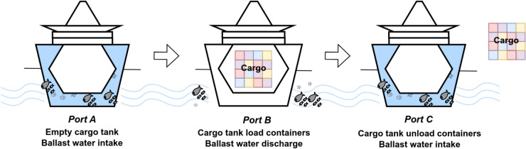
Aquatic non-indigenous species (NIS) pose significant threats to biodiversity, disrupting ecosystems and inflicting substantial economic damages across agriculture, forestry, and fisheries. Due to the fast growth of global trade and transportation networks, NIS has been introduced and spread unintentionally in new environments. This study develops a new physics-informed model to forecast maritime shipping traffic between port regions worldwide. The predicted information provided by these models, in turn, is used as input for risk assessment of NIS spread through transportation networks to evaluate the capability of our solution. Inspired by the gravity model for international trades, our model considers various factors that influence the likelihood and impact of vessel activities, such as shipping flux density, distance between ports, trade flow, and centrality measures of transportation hubs. Accordingly, this paper introduces transformers to gravity models to rebuild the short- and long-term dependencies that make the risk analysis feasible. Thus, we introduce a physics-inspired framework that achieves an 89% binary accuracy for existing and non-existing trajectories and an 84.8% accuracy for the number of vessels flowing between key port areas, representing more than 10% improvement over the traditional deep-gravity model. Along these lines, this research contributes to a better understanding of NIS risk assessment. It allows policymakers, conservationists, and stakeholders to prioritize management actions by identifying high-risk invasion pathways. Besides, our model is versatile and can include new data sources, making it suitable for assessing international vessel traffic flow in a changing global landscape.


Conflict of interest statement

The authors declare no competing interests.

Figures

Figure 1
Figure 1
Non-indigenous species carried by ballast water during container shipping.
Figure 2
Figure 2
Global Shipping Network 2017–2019. Edge color and thickness are relative to the number of shipping activities per route, with darker blue and bolder lines indicating routes with higher activity levels. Port sizes in color-coded circles are scaled according to shipping fluxes to highlight their port capacity.
Figure 3
Figure 3
The experimental pipeline for predicting ship traffic flows with gravity-informed models, including the assessment of environmental similarity used on the ballast water risk assessment case study. The process begins with identifying and verifying predicted links between source ports and target regions. Subsequently, key features are collected, and graph metrics are extracted so they can be used to inform the gravity-based model used to forecast ship traffic flow sizes. Concurrently, environmental data pertinent to the study regions is gathered and evaluated with the aim of computing environmental similarity metrics.
Figure 4
Figure 4
Validation and test accuracy of classifiers in the trajectory link prediction task: (a) The performance of the classification task includes Haversine distance, sea route distance, and edge importance as features; and, (b) The classification task is carried out without the edge importance features.
Figure 5
Figure 5
Framework of the Transformer Gravity model. The process starts with input sequences that are embedded and passed through self-attention blocks with multi-head attention, dropout, and layer normalization. This is followed by feed-forward blocks containing linear layers and dropout, resulting in the output sequence. The cross-entropy loss with log-softmax is used for training, while the Common Part of Commuters (CPC) is used for evaluation by incorporating commuting patterns Oi from the input data.
Figure 6
Figure 6
Distribution of environmental distances for shipping flows in 2019. The blue curve represents the true shipping flows, while the dashed red and green curves depict the predictions from the Transformer Gravity (TG) and Deep Gravity (DG) models, respectively. The x-axis measures the environmental distance; smaller values indicate higher risk levels, and larger values indicate lower risks.
Figure 7
Figure 7
The experiment pipeline for analyzing and predicting links in the global shipping network from 2017 to 2019 includes constructing the global shipping network, calculating centrality and PageRank graph metrics, fully connecting the shipping network for disconnected and weakly connected components, and performing link prediction to identify potential real shipping connections.

References

    1. Group, S. R. Container shipping—statistics & facts. https://www.statista.com/topics/1367/container-shipping/#topicOverview (2022).
    1. Barry, S. C. et al. Ballast water risk assessment: Principles, processes, and methods. ICES J. Mar. Sci.65, 121–131. 10.1093/icesjms/fsn004 (2008).10.1093/icesjms/fsn004 - DOI
    1. Seebens, H., Gastner, M. T. & Blasius, B. The risk of marine bioinvasion caused by global shipping. Ecol. Lett.16, 782–790. 10.1111/ele.12111 (2013). 10.1111/ele.12111 - DOI - PubMed
    1. Kaluza, P., Kölzsch, A., Gastner, M. T. & Blasius, B. The complex network of global cargo ship movements. J. Royal Soc. Interface7, 1093–1103. 10.1098/rsif.2009.0495 (2010).10.1098/rsif.2009.0495 - DOI - PMC - PubMed
    1. Haranwala, Y. J., Spadon, G., Renso, C. & Soares, A. A data augmentation algorithm for trajectory data. In: 1st ACM SIGSPATIAL International Workshop on Methods for Enriched Mobility Data: Emerging issues and Ethical perspectives 2023 (EMODE ’23), 5, 10.1145/3615885.3628008 (ACM, New York, NY, USA, New York, NY, USA, 2023).

LinkOut - more resources