

"ClusterApp": A Shiny R application to guide cluster studies based on GPS data
- PMID: 39045504
- PMCID: PMC11263757
- DOI: 10.1002/ece3.11695
"ClusterApp": A Shiny R application to guide cluster studies based on GPS data
Abstract
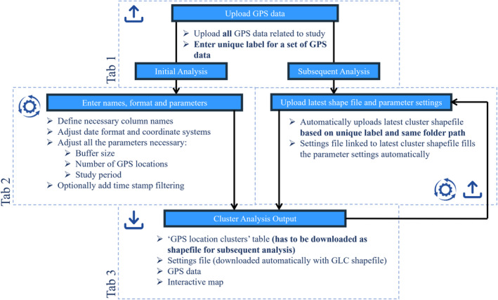
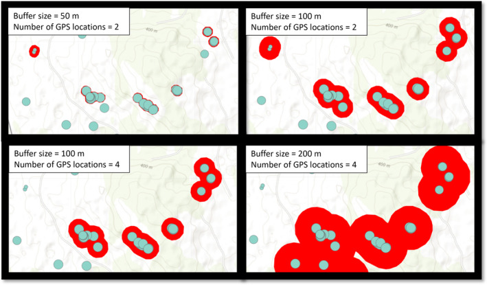
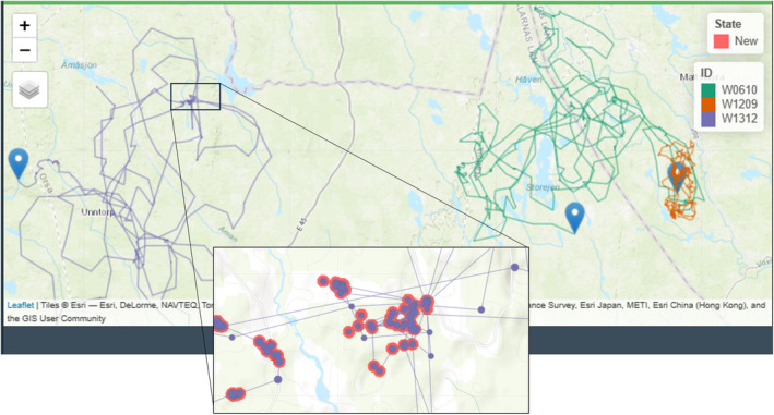
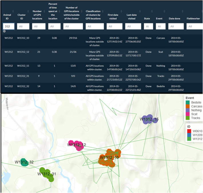
The rapid evolution of GPS devices, and therefore, collection of GPS data can be used to investigate a wide variety of topics in wildlife research. The combination of remotely collected GPS data with on-the-ground field investigations is a powerful tool for exploring behavioral ecology. "GPS cluster studies" are aimed at pinpointing and investigating identified clusters in the field. Activity clusters can be based on various parameters (e.g., distance between GPS locations and the number of locations needed to establish a cluster), which are closely related to the set research questions. Variation in methods across years within the same study may result in data collection biases. Therefore, a streamlined method to parametrize, generate interactive maps, and extract activity cluster data using a predefined approach will limit biases, and make field work and data management straightforward for field technicians. We developed the "ClusterApp" Shiny application in the R software to facilitate a step-by-step guide to execute cluster analyses and data management of cluster studies on any species using GPS data. We illustrate the use of the "ClusterApp" with two location datasets constructed by data collected on brown bears (Ursus arctos) and gray wolves (Canis lupus).
Keywords: Shiny application; animal activity; cluster analysis; fieldwork; movement data.
© 2024 The Author(s). Ecology and Evolution published by John Wiley & Sons Ltd.
Conflict of interest statement
The authors declare no conflict of interest.
Figures
Similar articles
-
The effect of sample site and collection procedure on identification of SARS-CoV-2 infection.Cochrane Database Syst Rev. 2024 Dec 16;12(12):CD014780. doi: 10.1002/14651858.CD014780. Cochrane Database Syst Rev. 2024. PMID: 39679851 Free PMC article.
-
Sexual Harassment and Prevention Training.2024 Mar 29. In: StatPearls [Internet]. Treasure Island (FL): StatPearls Publishing; 2025 Jan–. 2024 Mar 29. In: StatPearls [Internet]. Treasure Island (FL): StatPearls Publishing; 2025 Jan–. PMID: 36508513 Free Books & Documents.
-
Variation within and between digital pathology and light microscopy for the diagnosis of histopathology slides: blinded crossover comparison study.Health Technol Assess. 2025 Jul;29(30):1-75. doi: 10.3310/SPLK4325. Health Technol Assess. 2025. PMID: 40654002 Free PMC article.
-
Falls prevention interventions for community-dwelling older adults: systematic review and meta-analysis of benefits, harms, and patient values and preferences.Syst Rev. 2024 Nov 26;13(1):289. doi: 10.1186/s13643-024-02681-3. Syst Rev. 2024. PMID: 39593159 Free PMC article.
-
Bioengineered nerve conduits and wraps for peripheral nerve repair of the upper limb.Cochrane Database Syst Rev. 2022 Dec 7;12(12):CD012574. doi: 10.1002/14651858.CD012574.pub2. Cochrane Database Syst Rev. 2022. PMID: 36477774 Free PMC article.
References
-
- Cagnacci, F. , Boitani, L. , Powell, R. A. , & Boyce, M. S. (2010). Animal ecology meets GPS‐based radiotelemetry: A perfect storm of opportunities and challenges. Philosophical Transactions of the Royal Society B: Biological Sciences, 365(1550), 2157–2162. 10.1098/rstb.2010.0107 - DOI - PMC - PubMed
-
- Chang, W. , Cheng, J. , Allaire, J. , Sievert, C. , Schloerke, B. , Xie, Y. , Allen, J. , McPherson, J. , Dipert, A. , & Borges, B. (2023). Shiny: Web application framework for R. https://shiny.posit.co/
LinkOut - more resources
Full Text Sources
