

InSAR data for detection and modelling of overexploitation-induced subsidence: application in the industrial area of Prato (Italy)
- PMID: 39095514
- PMCID: PMC11297206
- DOI: 10.1038/s41598-024-67725-z
InSAR data for detection and modelling of overexploitation-induced subsidence: application in the industrial area of Prato (Italy)
Abstract
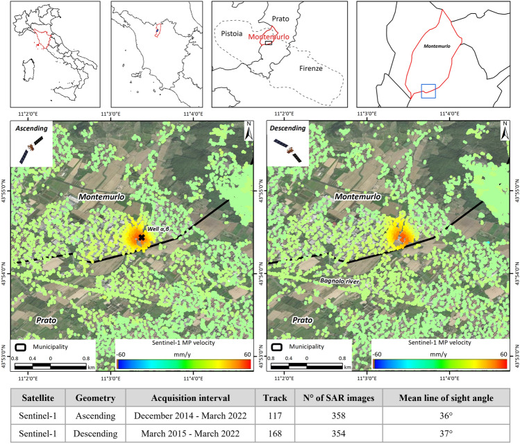
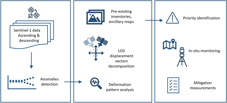
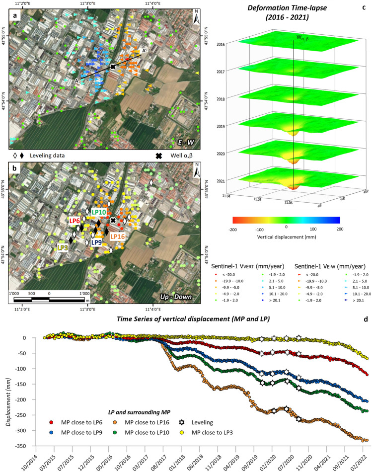
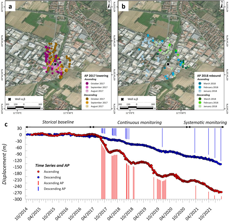
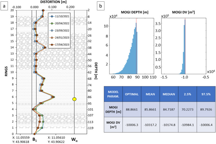
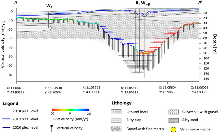
Spaceborne-based monitoring for environmental purposes has become a well-established practice. The recent progress of synthetic aperture radar (SAR) sensors, including through the European Space Agency's (ESA) Sentinel-1 constellation, has enabled the scientific community to identify and monitor several geohazards, including subsidence ground deformations. A case study in the Tuscany Region, Italy, highlights the effectiveness of interferometric synthetic aperture radar (InSAR) in detecting abrupt increases in ground deformation rates in an industrial area of Montemurlo municipality. In this case, InSAR data enabled prompt identification of the phenomenon, supporting the authorities in charge of environmental management to thoroughly investigate the situation. First, an on-site validation was performed via field surveys confirming the presence of cracks and fissures on some edifices. Further analysis, including water pumping rates, settlement gauge and topographic levelling, corroborated the InSAR data's findings regarding vertical deformation. Integration of collected data allowed for spatial identification and assessment of the subsidence bowl and its source depth recognized by the remote sensing data. The Montemurlo case offers a procedural guideline for managing abrupt accelerations, identified by InSAR data in subsidence-prone areas due to fluid overexploitation. In fact, these data proved useful in helping local authorities responsible for hydrogeomorphological risk management. With the exacerbation of deformation issues in subsidence-prone regions due to climate change, early detection and monitoring of such phenomena are increasingly crucial, with InSAR data playing a central role in achieving this goal.
Keywords: Field surveys; GBIS model; InSAR; Sentinel-1; Subsidence; Tuscany.
© 2024. The Author(s).
Conflict of interest statement
The authors declare no competing interests.
Figures
References
-
- Raspini, F. et al. Review of satellite radar interferometry for subsidence analysis. Earth Sci. Rev.235, 104239 (2022).10.1016/j.earscirev.2022.104239 - DOI
-
- Crosetto, M. et al. The evolution of wide-area dinsar: From regional and national services to the European ground motion service. Remote Sens.12, 2043 (2020).10.3390/rs12122043 - DOI
-
- Showstack, R. Sentinel satellites initiate new era in earth observation. Eos Trans. Am. Geophys. Union95, 239–240 (2014).10.1002/2014EO260003 - DOI
-
- Torres, R. et al. GMES Sentinel-1 mission. Remote Sens. Environ.120, 9–24 (2012).10.1016/j.rse.2011.05.028 - DOI
-
- Crosetto, M., Monserrat, O., Cuevas-González, M., Devanthéry, N. & Crippa, B. Persistent scatterer interferometry: A review. ISPRS J. Photogramm. Remote Sens.115, 78–89 (2016).10.1016/j.isprsjprs.2015.10.011 - DOI
LinkOut - more resources
Full Text Sources
Miscellaneous
