. 2024 Aug 6;14(1):18227.
doi: 10.1038/s41598-024-67914-w.

High-resolution mapping of urban Aedes aegypti immature abundance through breeding site detection based on satellite and street view imagery

Affiliations

High-resolution mapping of urban Aedes aegypti immature abundance through breeding site detection based on satellite and street view imagery

Steffen Knoblauch et al. Sci Rep. .

Erratum in

Abstract

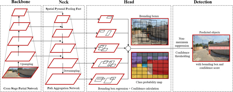
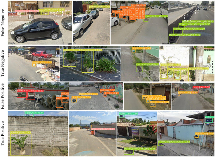
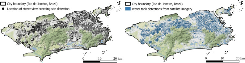
Identification of Aedes aegypti breeding hotspots is essential for the implementation of targeted vector control strategies and thus the prevention of several mosquito-borne diseases worldwide. Training computer vision models on satellite and street view imagery in the municipality of Rio de Janeiro, we analyzed the correlation between the density of common breeding grounds and Aedes aegypti infestation measured by ovitraps on a monthly basis between 2019 and 2022. Our findings emphasized the significance (p ≤ 0.05) of micro-habitat proxies generated through object detection, allowing to explain high spatial variance in urban abundance of Aedes aegypti immatures. Water tanks, non-mounted car tires, plastic bags, potted plants, and storm drains positively correlated with Aedes aegypti egg and larva counts considering a 1000 m mosquito flight range buffer around 2700 ovitrap locations, while dumpsters, small trash bins, and large trash bins exhibited a negative association. This complementary application of satellite and street view imagery opens the pathway for high-resolution interpolation of entomological surveillance data and has the potential to optimize vector control strategies. Consequently it supports the mitigation of emerging infectious diseases transmitted by Aedes aegypti, such as dengue, chikungunya, and Zika, which cause thousands of deaths each year.

Keywords: Aedes aegypti; Object detection; Ovitrap; Rio de Janeiro; Satellite; Street view.


Conflict of interest statement

The authors declare no competing interests.

Figures

Figure 1
Figure 1
Workflow of evaluating the density of Aedes aegypti breeding container detections for modeling immature mosquito abundance at flight range scale in the city of Rio de Janeiro, Brazil. The mapping of Aedes aegypti breeding containers was carried out using satellite and street view imagery by applying and fine-tuning single-stage object detection networks (left). Container densities were calculated within a circular flight range buffer of 1000 m around ovitrap locations. For the evaluation of the research question, univariate negative binomial regression models were trained using temporally aggregated egg and larva counts from entomological surveillance (middle). Entomological surveillance data about immature abundance of Aedes aegypti was collected by the municipal health ministry of Rio de Janeiro (right). ©2023 Google.
Figure 2
Figure 2
The images depicted identify breeding containers, accompanied by a map illustrating the coordinates of randomly selected train, test, and validation sets. These sets were chosen as subsets from a complete dataset of coordinates at 50 m intervals, encompassing the entire Open Street Map (OSM) road network in the municipality of Rio de Janeiro as of August 8th, 2023. Each train, test, and validation point corresponds to the downloading of five street view images, capturing a comprehensive 360-degree view at each location. This dataset compilation facilitated the training of object detection networks specifically tailored to identify Aedes aegypti breeding containers within the urban landscape. ©2023 Google.
Figure 3
Figure 3
Schematic YOLOv5x architecture applying upsampling for semantic enrichment and downsampling to augment image resolution. The backbone component shaped feature maps at various levels of granularity. Subsequently, the neck module merged these feature maps and forwards them to the prediction head. In this stage, the features were utilized to perform precise box and class predictions. © 2023 Google.
Figure 4
Figure 4
Schematic explanation of evaluation metrics applied to implemented Aedes aegypti breeding container detection networks.
Figure 5
Figure 5
Example for False Negative, True Negative, False Positive, and True Positive breeding container predictions utilizing street view imagery. Detected breeding containers were indicated by bounding boxes, with distinct colors assigned to each container class. These visual representations were generated based on the confidence scores derived from a fine-tuned YOLOv5 model. In the two first image rows, white and black dashed bounding boxes were manually added to point to the locations of False Negative (white) and True Negative (black) examples, respectively, to enhance explanation. © 2023 Google.
Figure 6
Figure 6
Large-scale Aedes aegypti breeding site detection from 461,152 street view and satellite imagery for the municipality of Rio de Janeiro, Brazil. Left map shows location of retrieved street view images used for 360-degree breeding site detection and right maps highlights water tank density detected from satellite imagery generated in Knoblauch et al..

References

    1. Wilke, A. B. B. et al. Proliferation of aedes aegypti in urban environments mediated by the availability of key aquatic habitats. Sci. Rep.10, 12925. 10.1038/s41598-020-69759-5 (2020). - PMC - PubMed
    1. Messina, J. P. et al. The current and future global distribution and population at risk of dengue. Nat. Microbiol.4, 1508–1515. 10.1038/s41564-019-0476-8 (2019). - PMC - PubMed
    1. Semenza, J. C., Rocklöv, J. & Ebi, K. L. Climate change and cascading risks from infectious disease. Infect. Dis. Therapy11, 1371–1390. 10.1007/s40121-022-00647-3 (2022). - PMC - PubMed
    1. Glassman, R., Scarpino, S. & Gilmour, J. The increasing burden of dengue fever in a changing climate: Multiple effects of climate change affect the incidence and severity of dengue fever (2022).
    1. Ebi, K. L. & Nealon, J. Dengue in a changing climate. Environ. Res.151, 115–123. 10.1016/j.envres.2016.07.026 (2016). - PubMed

LinkOut - more resources