

Identification of metacommunities in bioregions with historical habitat networks
- PMID: 39130098
- PMCID: PMC11309940
- DOI: 10.1002/ece3.70076
Identification of metacommunities in bioregions with historical habitat networks
Abstract
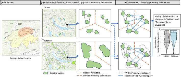
Although metacommunity theory provides many useful insights for conservation planning, the transfer of this knowledge to practice is hampered due to the difficulty of identifying metacommunities in bioregions. This study aims to identify the spatial extent of metacommunities at bioregional scales using current and historical habitat data, especially because contemporary biodiversity patterns may be a result of time-lagged responses to historical habitat configurations. Further, this estimation of the metacommunity spatial extent is based on both the habitat structure and the dispersal ability of the species. Focusing on dragonfly and damselfly (odonate) species in the eastern Swiss Plateau, the research uses wetland habitat information spanning over 110 years to create a time series of nine habitat networks between 1899 and 2010. From these networks, we identified the spatial extents of metacommunities based on the year of habitat information as well as on watershed boundaries. To identify the best metacommunity spatial extents, the study investigates whether patch pairs within a metacommunity exhibit greater similarity in species composition (i.e. lower beta-diversity) than patch pairs between metacommunities. For the different metacommunities, we further investigated correlations between gamma diversity and metacommunity size and compare them to theoretical expectations. In both analyses we found that augmenting spatial metacommunity identification with historical geographical proximity results in stronger associations with biodiversity patterns (beta and gamma diversity) than when using only current-day habitat or watershed information.
Keywords: biodiversity; conservation; habitat networks; landscape history; metacommunity.
© 2024 The Author(s). Ecology and Evolution published by John Wiley & Sons Ltd.
Conflict of interest statement
The authors declare that they have no known competing financial interests or personal relationships that could have appeared to influence the work reported in this paper.
Figures


References
-
- Anderson, M. J. , Crist, T. O. , Chase, J. M. , Vellend, M. , Inouye, B. D. , Freestone, A. L. , Sanders, N. J. , Cornell, H. V. , Comita, L. S. , Davies, K. F. , Harrison, S. P. , Kraft, N. J. B. , Stegen, J. C. , & Swenson, N. G. (2011). Navigating the multiple meanings of β diversity: A roadmap for the practicing ecologist. Ecology Letters, 14(1), 19–28. 10.1111/j.1461-0248.2010.01552.x - DOI - PubMed
-
- Angelibert, S. , & Giani, N. (2003). Dispersal characteristics of three odonate species in a patchy habitat. Ecography, 26(1), 13–20. 10.1034/j.1600-0587.2003.03372.x - DOI
-
- BAFU . (2006). Topographische Einzugsgebiete Schweizer Gewässer . https://www.bafu.admin.ch/bafu/de/home/themen/wasser/zustand/karten/geod...
-
- BAFU . (2022). Die biogeografischen Regionen der Schweiz Die biogeografischen Regionen der Schweiz .
LinkOut - more resources
Full Text Sources
